TopoQuest Logo
Do you find TopoQuest useful?
Help keep TopoQuest running and adding new maps/features by donating!
Bitcoin:  19c7KJd3qBynnjoSw5npx9KScwjBe4ifkT
Litecoin:  LXs6TkuXGGXo1vDsWCkWVdjQX94eUKd6ui
Home View Maps Find Maps Find Places Resources & Links


Jacksons Crossroads, Georgia Topographic Map

USGS Map Title: Jacksons Crossroads, GA
USGS Map MRC: 33082H7
DRG (GeoTIFF) Download: o33082h7.tif


Neighboring USGS Topographic Map Quads:


  Elberton West, GA  
34082A8
 

  Elberton East, GA  
34082A7
 

  Heardmont, GA  
34082A6
 

  Vesta, GA  
33082H8
 

  Jacksons Crossroads, GA  
33082H7
 

  Broad, GA  
33082H6
 

  Rayle, GA  
33082G8
 

  Celeste, GA  
33082G7
 

  Tignall, GA  
33082G6


Map MRC Location:

N34°
W83°
N34°
W82°
H8 H7 H6 H5 H4 H3 H2 H1
G8 G7 G6 G5 G4 G3 G2 G1
F8 F7 F6 F5 F4 F3 F2 F1
E8 E7 E6 E5 E4 E3 E2 E1
D8 D7 D6 D5 D4 D3 D2 D1
C8 C7 C6 C5 C4 C3 C2 C1
B8 B7 B6 B5 B4 B3 B2 B1
A8 A7 A6 A5 A4 A3 A2 A1
N33°
W83°
N33°
W82°

Jacksons Crossroads, GA USGS 1:24K Topographic Map Preview:
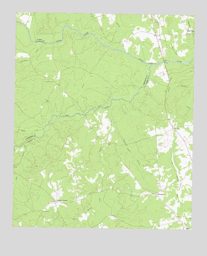
Jacksons Crossroads, GA USGS Topographic Map
Click on map above to begin viewing in our Map Viewer.

This topographic map contains these locations and features:
Feature Name Type Latitude Longitude GNIS ID View Map
Beck BranchStreamN33.8857°W82.8143°311014View Map
BellPopulated PlaceN33.9885°W82.7762°354533View Map
Bells BridgeBridgeN33.9723°W82.7710°342736View Map
Bullards Ferry (historical)CrossingN33.9807°W82.8096°335733View Map
Bunchs Mill (historical)LocaleN33.9462°W82.8154°335734View Map
Chatfield (historical)Populated PlaceN33.9007°W82.8615°342742View Map
Clark CreekStreamN33.9451°W82.8093°312689View Map
Clark Station ChurchChurchN33.8846°W82.8543°355173View Map
Clarks Station CemeteryCemeteryN33.8848°W82.8538°342744View Map
Clifford Grove ChurchChurchN33.8823°W82.8654°342745View Map
Falling CreekStreamN33.9785°W82.7982°355775View Map
Goose Pond (historical)Populated PlaceN33.9834°W82.8665°335752View Map
Goosepond CreekStreamN33.9826°W82.8538°314705View Map
Gunnells BridgeBridgeN33.9415°W82.8251°335754View Map
Hills Chapel (historical)ChurchN33.8965°W82.8521°342763View Map
Hoggs High School (historical)SchoolN33.8898°W82.8451°342764View Map
Jackson Cross Roads Fire DepartmentBuildingN33.8907°W82.8440°2604942View Map
Jacksons CrossroadsPopulated PlaceN33.8904°W82.8449°326339View Map
Kennedys GateLocaleN33.9707°W82.7799°335761View Map
Long CreekStreamN33.9710°W82.7787°328630View Map
Macks CreekStreamN33.9326°W82.8543°317584View Map
MallorysvilleLocaleN33.8951°W82.7743°317649View Map
Mallorysville CemeteryCemeteryN33.8968°W82.7787°342774View Map
Mallorysville ChurchChurchN33.8971°W82.7790°342775View Map
Mill BranchStreamN33.9240°W82.8679°318172View Map
New Ferry (historical)CrossingN33.9840°W82.8576°335778View Map
NormanPopulated PlaceN33.9340°W82.7632°326424View Map
Pole BranchStreamN33.8812°W82.7540°320970View Map
Rocky Branch CemeteryCemeteryN33.9601°W82.8474°321796View Map
Saint Johns CemeteryCemeteryN33.9248°W82.8076°322102View Map
Susan Smith BranchStreamN33.9362°W82.8051°323784View Map

Note: Coordinates in the location and feature list above are referenced to NAD83 datum.


Copyright (C) 2008-2025 Ryan Niemi / Sunset Dynamics ... All Rights Reserved