TopoQuest Logo
Do you find TopoQuest useful?
Help keep TopoQuest running and adding new maps/features by donating!
Bitcoin:  19c7KJd3qBynnjoSw5npx9KScwjBe4ifkT
Litecoin:  LXs6TkuXGGXo1vDsWCkWVdjQX94eUKd6ui
Home View Maps Find Maps Find Places Resources & Links


Vesta, Georgia Topographic Map

USGS Map Title: Vesta, GA
USGS Map MRC: 33082H8
DRG (GeoTIFF) Download: o33082h8.tif


Neighboring USGS Topographic Map Quads:


  Carlton, GA  
34083A1
 

  Elberton West, GA  
34082A8
 

  Elberton East, GA  
34082A7
 

  Sandy Cross, GA  
33083H1
 

  Vesta, GA  
33082H8
 

  Jacksons Crossroads, GA  
33082H7
 

  Lexington, GA  
33083G1
 

  Rayle, GA  
33082G8
 

  Celeste, GA  
33082G7


Map MRC Location:

N34°
W83°
N34°
W82°
H8 H7 H6 H5 H4 H3 H2 H1
G8 G7 G6 G5 G4 G3 G2 G1
F8 F7 F6 F5 F4 F3 F2 F1
E8 E7 E6 E5 E4 E3 E2 E1
D8 D7 D6 D5 D4 D3 D2 D1
C8 C7 C6 C5 C4 C3 C2 C1
B8 B7 B6 B5 B4 B3 B2 B1
A8 A7 A6 A5 A4 A3 A2 A1
N33°
W83°
N33°
W82°

Vesta, GA USGS 1:24K Topographic Map Preview:
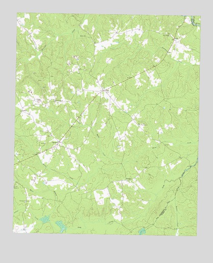
Vesta, GA USGS Topographic Map
Click on map above to begin viewing in our Map Viewer.

This topographic map contains these locations and features:
Feature Name Type Latitude Longitude GNIS ID View Map
Amos Mill (historical)LocaleN33.8790°W82.9632°335719View Map
Barbers BridgeBridgeN33.9146°W82.8799°335727View Map
Bethany ChurchChurchN33.9010°W82.9996°354580View Map
Bridges CemeteryCemeteryN33.9232°W82.9585°335731View Map
Burts ChurchChurchN33.9309°W82.9743°354916View Map
Dry Fork CreekStreamN33.9079°W82.8868°313682View Map
Earl Bolton CemeteryCemeteryN33.9321°W82.9246°335748View Map
EnterprisePopulated PlaceN33.9262°W82.9699°331666View Map
FairviewPopulated PlaceN33.9337°W82.9632°335750View Map
Faust CemeteryCemeteryN33.9021°W82.9540°335751View Map
Fort Bethel ChurchChurchN33.8929°W82.9910°314284View Map
Hobbs CemeteryCemeteryN33.9862°W82.9900°335756View Map
Hutton CreekStreamN33.8965°W82.8896°315870View Map
Indian CreekStreamN33.8768°W82.9676°315897View Map
Little Macks CreekStreamN33.9165°W82.9221°317116View Map
Locust Grove Church (historical)ChurchN33.9468°W82.8879°335765View Map
Millstone ChurchChurchN33.9876°W82.9515°318288View Map
New Hope ChurchChurchN33.9382°W82.9129°319429View Map
PalmettoPopulated PlaceN33.9060°W82.9229°332595View Map
Palmetto ChurchChurchN33.9057°W82.9232°335784View Map
Rains BranchStreamN33.8851°W82.9751°321288View Map
Rocky Branch ChurchChurchN33.9893°W82.8954°321800View Map
SaxonPopulated PlaceN33.9862°W82.8921°326505View Map
Sycorax (historical)Populated PlaceN33.9918°W82.9165°335797View Map
VeribestPopulated PlaceN33.9443°W82.9951°326572View Map
VestaPopulated PlaceN33.9565°W82.9385°326573View Map
Vesta Baptist ChurchChurchN33.9557°W82.9382°335800View Map
Vesta Volunteer Fire DepartmentBuildingN33.9566°W82.9404°2604956View Map
Vesta-Enterprise DivisionCivilN33.9540°W82.9543°1936615View Map
Watkins Grove ChurchChurchN33.9504°W82.9726°324913View Map

Note: Coordinates in the location and feature list above are referenced to NAD83 datum.


Copyright (C) 2008-2025 Ryan Niemi / Sunset Dynamics ... All Rights Reserved