TopoQuest Logo
Do you find TopoQuest useful?
Help keep TopoQuest running and adding new maps/features by donating!
Bitcoin:  19c7KJd3qBynnjoSw5npx9KScwjBe4ifkT
Litecoin:  LXs6TkuXGGXo1vDsWCkWVdjQX94eUKd6ui
Home View Maps Find Maps Find Places Resources & Links


Elbow Creek, Oregon Topographic Map

USGS Map Title: Elbow Creek, OR
USGS Map MRC: 45117H6
DRG (GeoTIFF) Download: o45117h6.tif


Neighboring USGS Topographic Map Quads:


  Godman Spring, WA  
46117A7
 

  Oregon Butte, WA  
46117A6
 

  Diamond Peak, WA  
46117A5
 

  Wenaha Forks, OR  
45117H7
 

  Elbow Creek, OR  
45117H6
 

  Eden Ridge, OR  
45117H5
 

  Fry Meadow, OR  
45117G7
 

  Deep Creek, OR  
45117G6
 

  Promise, OR  
45117G5


Map MRC Location:

N46°
W118°
N46°
W117°
H8 H7 H6 H5 H4 H3 H2 H1
G8 G7 G6 G5 G4 G3 G2 G1
F8 F7 F6 F5 F4 F3 F2 F1
E8 E7 E6 E5 E4 E3 E2 E1
D8 D7 D6 D5 D4 D3 D2 D1
C8 C7 C6 C5 C4 C3 C2 C1
B8 B7 B6 B5 B4 B3 B2 B1
A8 A7 A6 A5 A4 A3 A2 A1
N45°
W118°
N45°
W117°

Elbow Creek, OR USGS 1:24K Topographic Map Preview:
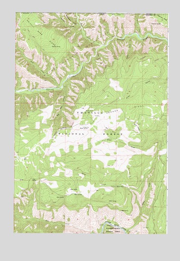
Elbow Creek, OR USGS Topographic Map
Click on map above to begin viewing in our Map Viewer.

This topographic map contains these locations and features:
Feature Name Type Latitude Longitude GNIS ID View Map
Alder SpringSpringN45.8999°W117.7046°1116840View Map
Ant FlatFlatN45.9990°W117.6738°1116964View Map
Bear CreekStreamN45.8751°W117.6857°1137699View Map
Big Hole CanyonValleyN45.9582°W117.7116°1117634View Map
Butte CreekStreamN45.9821°W117.6788°1118387View Map
Cross Canyon TrailTrailN45.9529°W117.6757°1119575View Map
Dry CreekStreamN45.9282°W117.6649°1120121View Map
Elbow CreekStreamN45.8768°W117.6599°1120423View Map
Grizzly Bear RidgeRidgeN45.9879°W117.7344°1121441View Map
Hoodoo RidgeRidgeN45.9454°W117.6621°1121963View Map
Huntit SpringSpringN45.9444°W117.6858°1122162View Map
Jacks SpringSpringN45.9052°W117.7356°1122349View Map
Meadow SpringSpringN45.9807°W117.7205°1124033View Map
Mosier SpringSpringN45.9345°W117.6904°1124385View Map
Mud SpringSpringN45.8881°W117.6626°1124494View Map
Patterson SpringSpringN45.9940°W117.6318°1125234View Map
Rock CreekStreamN45.9571°W117.7136°1148602View Map
Rock SpringSpringN45.9791°W117.7071°1129573View Map
Round MeadowFlatN45.9354°W117.6510°1126323View Map
Sheep SpringSpringN45.8953°W117.7094°1126844View Map
Skull SpringSpringN45.8935°W117.6728°1127042View Map
Téemux CreekStreamN45.9924°W117.6957°1158505View Map
Thorn SpringsSpringN45.8969°W117.6944°1128050View Map
tíkem CreekStreamN45.8888°W117.6463°1158504View Map
tíkem FallsFallsN45.9021°W117.6609°1127492View Map
Weller CreekStreamN45.9863°W117.6488°1509364View Map

Note: Coordinates in the location and feature list above are referenced to NAD83 datum.


Copyright (C) 2008-2024 Ryan Niemi / Sunset Dynamics ... All Rights Reserved