TopoQuest Logo
Do you find TopoQuest useful?
Help keep TopoQuest running and adding new maps/features by donating!
Bitcoin:  19c7KJd3qBynnjoSw5npx9KScwjBe4ifkT
Litecoin:  LXs6TkuXGGXo1vDsWCkWVdjQX94eUKd6ui
Home View Maps Find Maps Find Places Resources & Links


Eldred, Pennsylvania Topographic Map

USGS Map Title: Eldred, PA
USGS Map MRC: 41078H4
DRG (GeoTIFF) Download: o41078h4.tif


Neighboring USGS Topographic Map Quads:


  Knapp Creek, NY  
42078A5
 

  Olean, NY  
42078A4
 

  Portville, NY  
42078A3
 

  Derrick City, PA  
41078H5
 

  Eldred, PA  
41078H4
 

  Bullis Mills, PA  
41078H3
 

  Cyclone, PA  
41078G5
 

  Smethport, PA  
41078G4
 

  Port Allegany, PA  
41078G3


Map MRC Location:

N42°
W79°
N42°
W78°
H8 H7 H6 H5 H4 H3 H2 H1
G8 G7 G6 G5 G4 G3 G2 G1
F8 F7 F6 F5 F4 F3 F2 F1
E8 E7 E6 E5 E4 E3 E2 E1
D8 D7 D6 D5 D4 D3 D2 D1
C8 C7 C6 C5 C4 C3 C2 C1
B8 B7 B6 B5 B4 B3 B2 B1
A8 A7 A6 A5 A4 A3 A2 A1
N41°
W79°
N41°
W78°

Eldred, PA USGS 1:24K Topographic Map Preview:
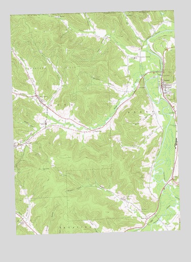
Eldred, PA USGS Topographic Map
Click on map above to begin viewing in our Map Viewer.

This topographic map contains these locations and features:
Feature Name Type Latitude Longitude GNIS ID View Map
Baker HollowValleyN41.8839°W78.4919°1168601View Map
Barden BrookStreamN41.9623°W78.3881°1168700View Map
Beers HollowValleyN41.9420°W78.3930°1169125View Map
Bell HollowValleyN41.9890°W78.3897°943588View Map
Berger HollowValleyN41.9343°W78.4810°1169289View Map
Big Loop HollowValleyN41.9946°W78.3816°943922View Map
BonnetLocaleN41.9815°W78.3939°1200722View Map
Borough of EldredCivilN41.9562°W78.3818°1215430View Map
Breese HollowValleyN41.9012°W78.4483°1170189View Map
Canfield CreekStreamN41.9415°W78.3797°1171158View Map
Carpenter CreekStreamN41.9370°W78.3795°1171243View Map
Columbia HillSummitN41.9115°W78.4786°1172247View Map
CoryvillePopulated PlaceN41.8826°W78.3984°1172480View Map
Drake HollowValleyN41.9852°W78.4270°1173446View Map
Duke CenterPopulated PlaceN41.9523°W78.4800°1173587View Map
Duke Center Post OfficePost OfficeN41.9530°W78.4808°2772676View Map
EldredPopulated PlaceN41.9578°W78.3853°1174085View Map
Eldred Borough Volunteer Fire Department Station 4BuildingN41.9567°W78.3838°2645812View Map
Eldred Post OfficePost OfficeN41.9577°W78.3859°2779952View Map
Eldred Township Volunteer Fire Department Station 18BuildingN41.9554°W78.4087°2645047View Map
Eldred Volunteer Ambulance Association Station 4BuildingN41.9567°W78.3839°2719625View Map
Fowler BrookStreamN41.9340°W78.3825°1175080View Map
Fowler Brook Church (historical)ChurchN41.9401°W78.3911°1200721View Map
HaymakerPopulated PlaceN41.9981°W78.4114°1176693View Map
Indian CreekStreamN41.9770°W78.3953°953645View Map
Indian CrossingPopulated PlaceN41.9737°W78.4047°1177750View Map
Kansas BranchStreamN41.9451°W78.4742°1178218View Map
Knapp CreekStreamN41.9662°W78.3859°954759View Map
Lamphier CemeteryCemeteryN41.9491°W78.3811°1178839View Map
LarabeePopulated PlaceN41.9045°W78.3789°1178885View Map
Little Loop HollowValleyN41.9981°W78.3820°955584View Map
Louds CreekStreamN41.9890°W78.3803°971975View Map
Mix CreekStreamN41.9828°W78.3964°957455View Map
Moody HollowValleyN41.8807°W78.3998°1181491View Map
Moody Hollow CemeteryCemeteryN41.8942°W78.4158°1181492View Map
North Branch Indian CreekStreamN41.9884°W78.4364°958704View Map
Oak Hill CemeteryCemeteryN41.9514°W78.3827°1182775View Map
Oil ValleyValleyN41.9548°W78.4830°1182889View Map
Otto Township Volunteer Fire CompanyBuildingN41.9393°W78.4752°2645814View Map
Otto-Eldred High SchoolSchoolN41.9376°W78.4742°1183093View Map
Potato CreekStreamN41.8901°W78.3770°1193158View Map
PrentisvalePopulated PlaceN41.9334°W78.4389°1184389View Map
Rices CreekStreamN41.8787°W78.3970°1202222View Map
RixfordPopulated PlaceN41.9262°W78.4942°1185154View Map
Rixford CemeteryCemeteryN41.9347°W78.4748°1185155View Map
Rixford Post OfficePost OfficeN41.9256°W78.4970°2772945View Map
Shrink HollowValleyN41.9915°W78.4556°1187623View Map
South Branch Knapp CreekStreamN41.9387°W78.4661°1188026View Map
Township of EldredCivilN41.9411°W78.3960°1216783View Map
Township of OttoCivilN41.9463°W78.4852°1216791View Map
Tram Hollow RunStreamN41.9520°W78.4811°1189712View Map
West EldredPopulated PlaceN41.9567°W78.4036°1191007View Map
WigwamPopulated PlaceN41.9978°W78.4625°1191379View Map
Windfall HollowValleyN41.9550°W78.4145°1191572View Map
Wrights CornersPopulated PlaceN41.8823°W78.4931°1191810View Map

Note: Coordinates in the location and feature list above are referenced to NAD83 datum.


Copyright (C) 2008-2025 Ryan Niemi / Sunset Dynamics ... All Rights Reserved