TopoQuest Logo
Do you find TopoQuest useful?
Help keep TopoQuest running and adding new maps/features by donating!
Bitcoin:  19c7KJd3qBynnjoSw5npx9KScwjBe4ifkT
Litecoin:  LXs6TkuXGGXo1vDsWCkWVdjQX94eUKd6ui
Home View Maps Find Maps Find Places Resources & Links


Elkhorn Hot Springs, Montana Topographic Map

USGS Map Title: Elkhorn Hot Springs, MT
USGS Map MRC: 45113D1
DRG (GeoTIFF) Download: o45113d1.tif


Neighboring USGS Topographic Map Quads:


  Odell Lake, MT  
45113E2
 

  Maurice Mountain, MT  
45113E1
 

  Mount Tahepia, MT  
45112E8
 

  Maverick Mountain, MT  
45113D2
 

  Elkhorn Hot Springs, MT  
45113D1
 

  Torrey Mountain, MT  
45112D8
 

  Tash Peak, MT  
45113C2
 

  Polaris, MT  
45113C1
 

  Ermont, MT  
45112C8


Map MRC Location:

N46°
W114°
N46°
W113°
H8 H7 H6 H5 H4 H3 H2 H1
G8 G7 G6 G5 G4 G3 G2 G1
F8 F7 F6 F5 F4 F3 F2 F1
E8 E7 E6 E5 E4 E3 E2 E1
D8 D7 D6 D5 D4 D3 D2 D1
C8 C7 C6 C5 C4 C3 C2 C1
B8 B7 B6 B5 B4 B3 B2 B1
A8 A7 A6 A5 A4 A3 A2 A1
N45°
W114°
N45°
W113°

Elkhorn Hot Springs, MT USGS 1:24K Topographic Map Preview:
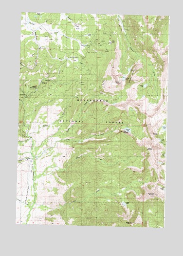
Elkhorn Hot Springs, MT USGS Topographic Map
Click on map above to begin viewing in our Map Viewer.

This topographic map contains these locations and features:
Feature Name Type Latitude Longitude GNIS ID View Map
04S12W29ACC_01 SpringSpringN45.4577°W113.1095°809583View Map
04S12W29CCCA01 WellWellN45.4510°W113.1198°809542View Map
05S12W08AADC01 WellWellN45.4174°W113.1023°809390View Map
05S12W08CBAA01 WellWellN45.4127°W113.1164°809371View Map
05S12W17CBBA01 WellWellN45.3988°W113.1198°809304View Map
Alturas Number One MountainSummitN45.3771°W113.0253°778992View Map
Alturas Number Two MountainSummitN45.3941°W113.0095°778993View Map
Anchor LakeLakeN45.4338°W113.0017°779025View Map
Aspen MineMineN45.4883°W113.0537°802412View Map
Aurora Post Office (historical)Post OfficeN45.4555°W113.1098°1797118View Map
Blue CreekStreamN45.4460°W113.1217°780139View Map
Blue Eyed Annie MineMineN45.4833°W113.0637°802411View Map
Boatman Lake MineMineN45.3833°W113.0009°802423View Map
Chain LakeSwampN45.4132°W113.0055°801877View Map
Chan LakeLakeN45.4271°W113.0058°781157View Map
Clark CreekStreamN45.4127°W113.1103°781313View Map
Comet MountainSummitN45.4596°W113.0439°781543View Map
CoolidgeLocaleN45.4894°W113.0364°793857View Map
Coolidge (historical)Populated PlaceN45.4894°W113.0364°1797321View Map
Coolidge Post Office (historical)Post OfficeN45.4894°W113.0364°1797228View Map
Coolidge School (historical)SchoolN45.4894°W113.0364°1797322View Map
Copper Queen MineMineN45.4755°W113.0675°802414View Map
Crystal ParkFlatN45.4883°W113.0942°781969View Map
Crystal Park Picnic AreaLocaleN45.4874°W113.1009°801774View Map
Dingley CreekStreamN45.4202°W113.1125°782386View Map
Dingley LakesLakeN45.4473°W113.0451°782387View Map
Dollar LakeLakeN45.3979°W113.0002°782454View Map
Dory CreekStreamN45.4260°W113.1145°782496View Map
Driveway TrailTrailN45.4585°W113.0906°782537View Map
Dutch ParkParkN45.4877°W113.0664°782732View Map
ElkhornPopulated PlaceN45.4894°W113.0364°783127View Map
Elkhorn Forest Service Station (historical)LocaleN45.4577°W113.1070°801773View Map
Elkhorn Hot SpringsSpringN45.4590°W113.1072°783133View Map
Elkhorn Hot SpringsPopulated PlaceN45.4555°W113.1098°783143View Map
Elkhorn LakeLakeN45.4585°W113.0190°783134View Map
Elkhorn Mill MineMineN45.4949°W113.0414°802259View Map
Elkhorn Ore MillLocaleN45.4933°W113.0403°794554View Map
Elkhorn ParkFlatN45.4755°W113.1112°783136View Map
Elkhorn School (historical)SchoolN45.4894°W113.0364°1797323View Map
Elkhorn Upper CampLocaleN45.4888°W113.0467°783144View Map
Gar MineMineN45.4599°W113.0528°783822View Map
Gar MineMineN45.4591°W113.0531°802415View Map
Goat MountainSummitN45.4305°W113.0367°784013View Map
Goodenough ParkParkN45.4738°W113.0784°784093View Map
Grasshopper CampgroundLocaleN45.4516°W113.1198°794555View Map
Grasshopper CampgroundLocaleN45.4519°W113.1195°801772View Map
Grasshopper Valley Fire DepartmentBuildingN45.4158°W113.1150°2546577View Map
Guy MineMineN45.4583°W113.0731°802430View Map
Hall LakeLakeN45.4676°W113.0333°784485View Map
Harrison ParkFlatN45.4913°W113.1125°784587View Map
Highboy MountainSummitN45.4210°W113.0117°784867View Map
Hopkin LakeLakeN45.4628°W113.0375°785003View Map
Hot Springs CreekStreamN45.4499°W113.1206°785086View Map
Lake CreekStreamN45.3871°W113.1103°785900View Map
Lost Cloud MineMineN45.4846°W113.0609°802413View Map
Magna MineMineN45.4533°W113.0559°802431View Map
Magna MineMineN45.4538°W113.0556°786774View Map
Maverick Mountain RV ParkLocaleN45.4513°W113.1203°1797182View Map
Old Elkhorn MineMineN45.4896°W113.0392°802419View Map
Old Elkhorn MineMineN45.4899°W113.0395°788410View Map
Ore MillLocaleN45.4944°W113.0420°788482View Map
Park MineMineN45.4833°W113.0489°802416View Map
Park MineMineN45.4833°W113.0498°788645View Map
Polaris LakeLakeN45.3886°W113.0345°789047View Map
Price CreekStreamN45.4796°W113.1092°789182View Map
Rhubarb Patch TrailTrailN45.4399°W113.0853°789555View Map
Saddleback MountainSummitN45.4610°W113.0309°789898View Map
Saint Louis GulchValleyN45.4933°W113.1059°789939View Map
Sawtooth LakeLakeN45.4322°W113.0326°790087View Map
Sawtooth MountainSummitN45.4302°W113.0120°790090View Map
Shale CreekStreamN45.4135°W113.1120°790272View Map
Sheldon ParkFlatN45.4944°W113.0817°790385View Map
Shoestring CreekStreamN45.4677°W113.1220°790428View Map
Snyder CreekStreamN45.3852°W113.1128°790815View Map
Upper Elkhorn CampLocaleN45.4841°W113.0503°794553View Map
Upper Elkhorn MineMineN45.4883°W113.0453°802418View Map
Wellman CreekStreamN45.4266°W113.1162°792936View Map
Wellman MineMineN45.4466°W113.0825°792937View Map
White CreekStreamN45.4008°W113.1117°793189View Map

Note: Coordinates in the location and feature list above are referenced to NAD83 datum.


Copyright (C) 2008-2025 Ryan Niemi / Sunset Dynamics ... All Rights Reserved