TopoQuest Logo
Do you find TopoQuest useful?
Help keep TopoQuest running and adding new maps/features by donating!
Bitcoin:  19c7KJd3qBynnjoSw5npx9KScwjBe4ifkT
Litecoin:  LXs6TkuXGGXo1vDsWCkWVdjQX94eUKd6ui
Home View Maps Find Maps Find Places Resources & Links


Ellington, Michigan Topographic Map

USGS Map Title: Ellington, MI
USGS Map MRC: 43083E3
DRG (GeoTIFF) Download: o43083e3.tif


Neighboring USGS Topographic Map Quads:


  Sebewaing, MI  
43083F4
 

  Owendale, MI  
43083F3
 

  Gagetown, MI  
43083F2
 

  Colling, MI  
43083E4
 

  Ellington, MI  
43083E3
 

  Cass City, MI  
43083E2
 

  Caro, MI  
43083D4
 

  East Dayton, MI  
43083D3
 

  Kingston, MI  
43083D2


Map MRC Location:

N44°
W84°
N44°
W83°
H8 H7 H6 H5 H4 H3 H2 H1
G8 G7 G6 G5 G4 G3 G2 G1
F8 F7 F6 F5 F4 F3 F2 F1
E8 E7 E6 E5 E4 E3 E2 E1
D8 D7 D6 D5 D4 D3 D2 D1
C8 C7 C6 C5 C4 C3 C2 C1
B8 B7 B6 B5 B4 B3 B2 B1
A8 A7 A6 A5 A4 A3 A2 A1
N43°
W84°
N43°
W83°

Ellington, MI USGS 1:24K Topographic Map Preview:
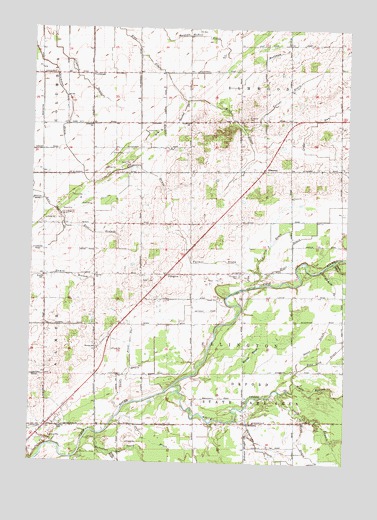
Ellington, MI USGS Topographic Map
Click on map above to begin viewing in our Map Viewer.

This topographic map contains these locations and features:
Feature Name Type Latitude Longitude GNIS ID View Map
Albrandt DrainCanalN43.5514°W83.2544°619908View Map
Almer CemeteryCemeteryN43.5097°W83.3719°620010View Map
Butternut CreekStreamN43.5067°W83.3530°622392View Map
Call DrainCanalN43.5050°W83.3227°622464View Map
Camp Pine AcresLocaleN43.5022°W83.3544°622621View Map
Columbian DrainCanalN43.6020°W83.3602°623644View Map
ColwoodPopulated PlaceN43.6117°W83.3522°1617498View Map
Colwood ChurchChurchN43.5970°W83.3519°623652View Map
Colwood Post Office (historical)Post OfficeN43.6117°W83.3522°2553981View Map
Colwood United Brethren ChurchChurchN43.5189°W83.3478°2553897View Map
Deford State Game AreaParkN43.5136°W83.2786°624511View Map
Doerr DrainCanalN43.5342°W83.2611°624739View Map
East Branch Anti Mason DrainCanalN43.5659°W83.3463°625122View Map
EllingtonPopulated PlaceN43.5539°W83.3213°1617540View Map
Ellington CemeteryCemeteryN43.5542°W83.2924°625475View Map
Ellington Nazarene ChurchChurchN43.5464°W83.3181°2553875View Map
Ellington Post Office (historical)Post OfficeN43.5539°W83.3214°2553976View Map
ElmwoodPopulated PlaceN43.5847°W83.2833°1617542View Map
Elmwood CemeteryCemeteryN43.5989°W83.2905°625530View Map
Elmwood Post Office (historical)Post OfficeN43.5847°W83.2831°2553975View Map
Farmer DrainCanalN43.5581°W83.3016°625830View Map
Frost DrainCanalN43.5345°W83.3350°626524View Map
George SchoolSchoolN43.5331°W83.3486°626738View Map
H and S DrainCanalN43.5631°W83.2799°627565View Map
Haidyjz McNeil DrainCanalN43.6231°W83.3086°627604View Map
Haney MarshSwampN43.5311°W83.2869°627724View Map
Hiser DrainCanalN43.5595°W83.2713°628353View Map
Humes SchoolSchoolN43.5534°W83.3702°628806View Map
King DrainCanalN43.6228°W83.3397°629696View Map
Lazell DrainCanalN43.5256°W83.3363°630231View Map
Lockwood DrainCanalN43.6109°W83.3563°630861View Map
Marker DrainCanalN43.5909°W83.3227°631573View Map
Markham DrainCanalN43.6181°W83.2777°631580View Map
Michigan Department of Natural Resources Cass City Field OfficeBuildingN43.5981°W83.2724°2626864View Map
North Branch White CreekStreamN43.5206°W83.2758°633545View Map
Orr-Moore SchoolSchoolN43.5111°W83.2891°634111View Map
Pinerest Mobile EstatesPopulated PlaceN43.5119°W83.3633°2553904View Map
Reorganized Church of Jesus Christ of Latter Day SaintsChurchN43.5106°W83.3622°2553892View Map
South Branch White CreekStreamN43.5206°W83.2758°638324View Map
Stankul DrainCanalN43.6014°W83.3161°638720View Map
Sunshine ChurchChurchN43.5978°W83.3133°639106View Map
Sutton ChurchChurchN43.5536°W83.3497°639129View Map
Township of EllingtonCivilN43.5406°W83.2900°1626228View Map
Turner DrainCanalN43.6059°W83.2763°1615183View Map
Tuscola County Poor Farm CemeteryCemeteryN43.5100°W83.3678°2554507View Map
White CreekStreamN43.5217°W83.3186°1616301View Map

Note: Coordinates in the location and feature list above are referenced to NAD83 datum.


Copyright (C) 2008-2024 Ryan Niemi / Sunset Dynamics ... All Rights Reserved