TopoQuest Logo
Do you find TopoQuest useful?
Help keep TopoQuest running and adding new maps/features by donating!
Bitcoin:  19c7KJd3qBynnjoSw5npx9KScwjBe4ifkT
Litecoin:  LXs6TkuXGGXo1vDsWCkWVdjQX94eUKd6ui
Home View Maps Find Maps Find Places Resources & Links


Colling, Michigan Topographic Map

USGS Map Title: Colling, MI
USGS Map MRC: 43083E4
DRG (GeoTIFF) Download: o43083e4.tif


Neighboring USGS Topographic Map Quads:


  Fish Point, MI  
43083F5
 

  Sebewaing, MI  
43083F4
 

  Owendale, MI  
43083F3
 

  Fairgrove, MI  
43083E5
 

  Colling, MI  
43083E4
 

  Ellington, MI  
43083E3
 

  Gilford, MI  
43083D5
 

  Caro, MI  
43083D4
 

  East Dayton, MI  
43083D3


Map MRC Location:

N44°
W84°
N44°
W83°
H8 H7 H6 H5 H4 H3 H2 H1
G8 G7 G6 G5 G4 G3 G2 G1
F8 F7 F6 F5 F4 F3 F2 F1
E8 E7 E6 E5 E4 E3 E2 E1
D8 D7 D6 D5 D4 D3 D2 D1
C8 C7 C6 C5 C4 C3 C2 C1
B8 B7 B6 B5 B4 B3 B2 B1
A8 A7 A6 A5 A4 A3 A2 A1
N43°
W84°
N43°
W83°

Colling, MI USGS 1:24K Topographic Map Preview:
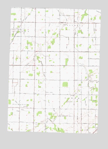
Colling, MI USGS Topographic Map
Click on map above to begin viewing in our Map Viewer.

This topographic map contains these locations and features:
Feature Name Type Latitude Longitude GNIS ID View Map
Alex DrainCanalN43.6039°W83.4016°619932View Map
Almer Center SchoolSchoolN43.5381°W83.4091°620011View Map
Almer Township HallBuildingN43.5044°W83.3778°2553878View Map
Anti Mason DrainCanalN43.5959°W83.3852°620147View Map
Bach DrainCanalN43.6236°W83.4352°620408View Map
Bethel ChurchChurchN43.5384°W83.4638°621220View Map
Bills Rohlfs DrainCanalN43.5295°W83.4894°621380View Map
Caro Area Health ClinicHospitalN43.5039°W83.3883°2553845View Map
CollingPopulated PlaceN43.6111°W83.4091°1617495View Map
Colling Nazarene ChurchChurchN43.6125°W83.4122°2554364View Map
Colling Post Office (historical)Post OfficeN43.6111°W83.4092°2553983View Map
Colling StationLocaleN43.6111°W83.4125°2553960View Map
Columbia CemeteryCemeteryN43.6092°W83.4272°623630View Map
Columbia CornersLocaleN43.6109°W83.4316°623632View Map
Columbia Post Office (historical)Post OfficeN43.6108°W83.4317°2553982View Map
Cutler DrainCanalN43.5003°W83.4475°624254View Map
Davenport UniversitySchoolN43.5047°W83.3872°2553863View Map
Demorest CemeteryCemeteryN43.6008°W83.4947°624544View Map
Fairgrove ChurchChurchN43.5206°W83.4844°625752View Map
Free Methodist ChurchChurchN43.5044°W83.3753°2553879View Map
Gilbert BranchStreamN43.5770°W83.4636°626801View Map
Great Lakes Baptist ChurchChurchN43.5667°W83.4806°2554502View Map
Highland Pines SchoolSchoolN43.5069°W83.3872°2553864View Map
Hoover DrainCanalN43.5897°W83.4977°628545View Map
Humes BranchStreamN43.5531°W83.3875°628804View Map
Jordon DrainCanalN43.5845°W83.4750°629397View Map
Lewis SchoolSchoolN43.5600°W83.4497°630353View Map
Lighthouse Baptist ChurchChurchN43.5075°W83.3883°2553865View Map
Michigan State Police District 3 Caro Post 33BuildingN43.5093°W83.3890°2780873View Map
Parsell SchoolSchoolN43.5681°W83.4225°634429View Map
Pike DrainCanalN43.5206°W83.4938°634865View Map
Prin DrainCanalN43.5270°W83.4383°635458View Map
Providence ChurchChurchN43.5047°W83.3753°2554000View Map
Romain DrainCanalN43.5403°W83.4433°636141View Map
Ross BranchStreamN43.5336°W83.3933°636246View Map
Saint Peters CemeteryCemeteryN43.6197°W83.4313°638687View Map
Saint Peters ChurchChurchN43.6145°W83.4322°638688View Map
Streeter DrainCanalN43.5297°W83.3930°638950View Map
Sugartree Mobile Home ParkPopulated PlaceN43.5036°W83.3794°2553900View Map
Township of AlmerCivilN43.5396°W83.4074°1625828View Map

Note: Coordinates in the location and feature list above are referenced to NAD83 datum.


Copyright (C) 2008-2025 Ryan Niemi / Sunset Dynamics ... All Rights Reserved