TopoQuest Logo
Do you find TopoQuest useful?
Help keep TopoQuest running and adding new maps/features by donating!
Bitcoin:  19c7KJd3qBynnjoSw5npx9KScwjBe4ifkT
Litecoin:  LXs6TkuXGGXo1vDsWCkWVdjQX94eUKd6ui
Home View Maps Find Maps Find Places Resources & Links


Elm Grove, Louisiana Topographic Map

USGS Map Title: Elm Grove, LA
USGS Map MRC: 32093C5
DRG (GeoTIFF) Download: o32093c5.tif


Neighboring USGS Topographic Map Quads:


  Shreveport East, LA  
32093D6
 

  Sligo, LA  
32093D5
 

  Koran, LA  
32093D4
 

  Wallace Lake, LA  
32093C6
 

  Elm Grove, LA  
32093C5
 

  Bossier Point, LA  
32093C4
 

  Holly, LA  
32093B6
 

  Clear Lake, LA  
32093B5
 

  East Point, LA  
32093B4


Map MRC Location:

N33°
W94°
N33°
W93°
H8 H7 H6 H5 H4 H3 H2 H1
G8 G7 G6 G5 G4 G3 G2 G1
F8 F7 F6 F5 F4 F3 F2 F1
E8 E7 E6 E5 E4 E3 E2 E1
D8 D7 D6 D5 D4 D3 D2 D1
C8 C7 C6 C5 C4 C3 C2 C1
B8 B7 B6 B5 B4 B3 B2 B1
A8 A7 A6 A5 A4 A3 A2 A1
N32°
W94°
N32°
W93°

Elm Grove, LA USGS 1:24K Topographic Map Preview:
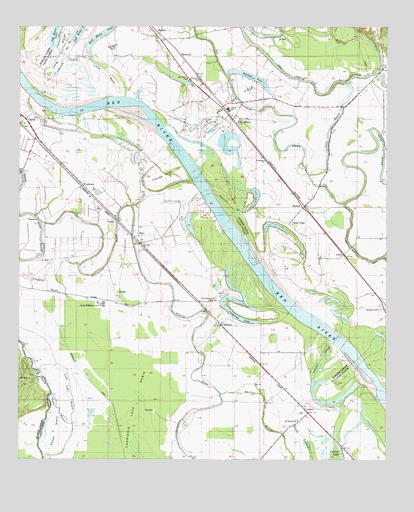
Elm Grove, LA USGS Topographic Map
Click on map above to begin viewing in our Map Viewer.

This topographic map contains these locations and features:
Feature Name Type Latitude Longitude GNIS ID View Map
Alligators BayouStreamN32.2979°W93.6093°532142View Map
AtkinsPopulated PlaceN32.3096°W93.5149°553322View Map
Atkins Gas FieldOilfieldN32.3182°W93.5335°550767View Map
Baptist Christian CollegeSchoolN32.2949°W93.5968°552217View Map
Bayou LachuteGutN32.2529°W93.5260°532659View Map
Campo Bello School (historical)SchoolN32.2599°W93.5330°541039View Map
CaspianaPopulated PlaceN32.2890°W93.5563°541066View Map
Caspiana Gas FieldOilfieldN32.2904°W93.6155°556603View Map
Caspiana LakeLakeN32.2909°W93.5499°553916View Map
CecilePopulated PlaceN32.3196°W93.5921°553932View Map
Cross BayouStreamN32.3324°W93.5263°534275View Map
Elm GrovePopulated PlaceN32.3482°W93.5527°554352View Map
Elm Grove Baptist ChurchChurchN32.3602°W93.5682°554353View Map
Elm Grove Middle SchoolSchoolN32.3511°W93.5536°550817View Map
Elm Grove Oil and Gas FieldOilfieldN32.3507°W93.5571°541040View Map
Elm Grove Post OfficePost OfficeN32.3492°W93.5542°1631502View Map
Evergreen ChurchChurchN32.3365°W93.5416°534866View Map
Flat River DitchCanalN32.3088°W93.5016°534996View Map
Gayles Gas FieldOilfieldN32.3399°W93.6188°552290View Map
George Washington Carver Primary School (historical)SchoolN32.2952°W93.5963°1629645View Map
Goose IslandIslandN32.2582°W93.6124°535286View Map
Goose Island School (historical)SchoolN32.2702°W93.6074°541034View Map
Half Moon LakeLakeN32.3747°W93.5940°554645View Map
Huron School (historical)SchoolN32.2979°W93.6163°541035View Map
Knot PointPopulated PlaceN32.3185°W93.5330°543363View Map
LachutePopulated PlaceN32.2638°W93.5266°541121View Map
Lachute School (historical)SchoolN32.2665°W93.5682°541036View Map
LagasPopulated PlaceN32.3588°W93.5627°550848View Map
Little BendBendN32.3618°W93.5955°536497View Map
MagentaPopulated PlaceN32.3738°W93.5785°543429View Map
Magnolia School (historical)SchoolN32.3049°W93.5743°541037View Map
McDadePopulated PlaceN32.3235°W93.5282°541139View Map
McDade Post Office (historical)Post OfficeN32.3232°W93.5280°1631515View Map
Mechanisville ChurchChurchN32.2960°W93.5593°537024View Map
MoramealPopulated PlaceN32.3668°W93.5702°543485View Map
MossPopulated PlaceN32.3146°W93.5843°543490View Map
Mount Pleasant ChurchChurchN32.2615°W93.5302°537393View Map
Mount Sinai ChurchChurchN32.2935°W93.5032°537403View Map
Negro BayouGutN32.2640°W93.6110°537536View Map
Old River LakeLakeN32.3734°W93.6128°555552View Map
Palestine School (historical)SchoolN32.3274°W93.5835°541038View Map
Pascagoula BayouStreamN32.3013°W93.5805°555599View Map
Pascagoula CanalCanalN32.2674°W93.5946°537987View Map
Pilkinton AirstripAirportN32.3315°W93.5215°2676771View Map
Raft BayouStreamN32.3624°W93.5027°538480View Map
Stumpy LakeLakeN32.3604°W93.5466°556153View Map
WoodchuckPopulated PlaceN32.3293°W93.6035°543795View Map
Youngs Point LandingCapeN32.3302°W93.5805°540582View Map

Note: Coordinates in the location and feature list above are referenced to NAD83 datum.


Copyright (C) 2008-2024 Ryan Niemi / Sunset Dynamics ... All Rights Reserved