TopoQuest Logo
Do you find TopoQuest useful?
Help keep TopoQuest running and adding new maps/features by donating!
Bitcoin:  19c7KJd3qBynnjoSw5npx9KScwjBe4ifkT
Litecoin:  LXs6TkuXGGXo1vDsWCkWVdjQX94eUKd6ui
Home View Maps Find Maps Find Places Resources & Links


Clear Lake, Louisiana Topographic Map

USGS Map Title: Clear Lake, LA
USGS Map MRC: 32093B5
DRG (GeoTIFF) Download: o32093b5.tif


Neighboring USGS Topographic Map Quads:


  Wallace Lake, LA  
32093C6
 

  Elm Grove, LA  
32093C5
 

  Bossier Point, LA  
32093C4
 

  Holly, LA  
32093B6
 

  Clear Lake, LA  
32093B5
 

  East Point, LA  
32093B4
 

  Mansfield, LA  
32093A6
 

  Bayou Pierre Lake, LA  
32093A5
 

  Harmon, LA  
32093A4


Map MRC Location:

N33°
W94°
N33°
W93°
H8 H7 H6 H5 H4 H3 H2 H1
G8 G7 G6 G5 G4 G3 G2 G1
F8 F7 F6 F5 F4 F3 F2 F1
E8 E7 E6 E5 E4 E3 E2 E1
D8 D7 D6 D5 D4 D3 D2 D1
C8 C7 C6 C5 C4 C3 C2 C1
B8 B7 B6 B5 B4 B3 B2 B1
A8 A7 A6 A5 A4 A3 A2 A1
N32°
W94°
N32°
W93°

Clear Lake, LA USGS 1:24K Topographic Map Preview:
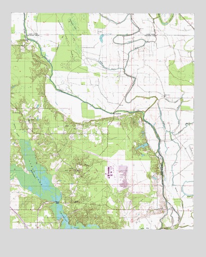
Clear Lake, LA USGS Topographic Map
Click on map above to begin viewing in our Map Viewer.

This topographic map contains these locations and features:
Feature Name Type Latitude Longitude GNIS ID View Map
Ash BayouGutN32.1924°W93.5121°532226View Map
Bill Gay IslandIslandN32.1668°W93.5232°533119View Map
Boggy BayouGutN32.2179°W93.5593°533277View Map
Cannisnia LakeLakeN32.2429°W93.5824°558184View Map
Cannisnia Lake BasinBasinN32.2382°W93.5882°533755View Map
Cannisnia Lake Gas FieldOilfieldN32.1918°W93.5766°545593View Map
Clear LakeReservoirN32.1316°W93.5886°545600View Map
Clear Lake OneReservoirN32.1316°W93.5886°554023View Map
Cowpen BayouGutN32.1899°W93.5230°534217View Map
Crook All BayouStreamN32.1727°W93.6107°534248View Map
Gay Island Oil FieldOilfieldN32.1849°W93.5307°545626View Map
Gravel Point BridgeBridgeN32.2346°W93.6132°535363View Map
Hog Thief PointRidgeN32.1632°W93.5543°541307View Map
Howard Point School (historical)SchoolN32.1363°W93.5549°541306View Map
Lachute Gas FieldOilfieldN32.2410°W93.5682°552331View Map
Lachute LakeLakeN32.2468°W93.5167°554961View Map
LaCoup BridgeBridgeN32.1921°W93.5549°536246View Map
Long Lake BayouStreamN32.2465°W93.6155°536702View Map
New Friendship CemeteryCemeteryN32.1877°W93.6135°558272View Map
New Friendship ChurchChurchN32.1918°W93.6188°558273View Map
Oakdale ChurchChurchN32.2488°W93.5343°543850View Map
Phillips BayouStreamN32.2332°W93.5335°538104View Map
Prairie RiverStreamN32.1924°W93.5349°555722View Map
Rambin BayouStreamN32.1765°W93.6199°538487View Map
Red Lake BayouStreamN32.1560°W93.5971°558163View Map
Red Lake ChurchChurchN32.1590°W93.5813°558299View Map
Rolling Lake BayouGutN32.1279°W93.5118°538694View Map
Savanna Mission School (historical)SchoolN32.1804°W93.5760°541308View Map
Sawlog LakeLakeN32.1263°W93.5260°555984View Map
Star Point ChurchChurchN32.1365°W93.5246°558323View Map
Sunshine ChurchChurchN32.1404°W93.5810°558327View Map
Thorn Lake (historical)LakeN32.2123°W93.5254°548767View Map
Thorn Lake Gas FieldOilfieldN32.2293°W93.5171°548768View Map
Watson BayouGutN32.1729°W93.5099°540257View Map
Willow BayouGutN32.1990°W93.5155°540449View Map
Willow Bayou ChurchChurchN32.2021°W93.5202°540453View Map

Note: Coordinates in the location and feature list above are referenced to NAD83 datum.


Copyright (C) 2008-2025 Ryan Niemi / Sunset Dynamics ... All Rights Reserved