TopoQuest Logo
Do you find TopoQuest useful?
Help keep TopoQuest running and adding new maps/features by donating!
Bitcoin:  19c7KJd3qBynnjoSw5npx9KScwjBe4ifkT
Litecoin:  LXs6TkuXGGXo1vDsWCkWVdjQX94eUKd6ui
Home View Maps Find Maps Find Places Resources & Links


Holly, Louisiana Topographic Map

USGS Map Title: Holly, LA
USGS Map MRC: 32093B6
DRG (GeoTIFF) Download: o32093b6.tif


Neighboring USGS Topographic Map Quads:


  Stonewall, LA  
32093C7
 

  Wallace Lake, LA  
32093C6
 

  Elm Grove, LA  
32093C5
 

  Gloster, LA  
32093B7
 

  Holly, LA  
32093B6
 

  Clear Lake, LA  
32093B5
 

  Grand Cane, LA  
32093A7
 

  Mansfield, LA  
32093A6
 

  Bayou Pierre Lake, LA  
32093A5


Map MRC Location:

N33°
W94°
N33°
W93°
H8 H7 H6 H5 H4 H3 H2 H1
G8 G7 G6 G5 G4 G3 G2 G1
F8 F7 F6 F5 F4 F3 F2 F1
E8 E7 E6 E5 E4 E3 E2 E1
D8 D7 D6 D5 D4 D3 D2 D1
C8 C7 C6 C5 C4 C3 C2 C1
B8 B7 B6 B5 B4 B3 B2 B1
A8 A7 A6 A5 A4 A3 A2 A1
N32°
W94°
N32°
W93°

Holly, LA USGS 1:24K Topographic Map Preview:
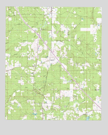
Holly, LA USGS Topographic Map
Click on map above to begin viewing in our Map Viewer.

This topographic map contains these locations and features:
Feature Name Type Latitude Longitude GNIS ID View Map
Bayou Na BonchasseStreamN32.1554°W93.6305°553496View Map
Brushy BayouStreamN32.2165°W93.6960°533460View Map
Caldwell BayouStreamN32.2096°W93.6632°533618View Map
Calvary Church (historical)ChurchN32.1365°W93.6363°541305View Map
Caney BayouStreamN32.1563°W93.6277°553878View Map
De Soto Fire District 9BuildingN32.2439°W93.6913°2672839View Map
Edwards BayouStreamN32.2102°W93.7443°534769View Map
Evergreen CemeteryCemeteryN32.2253°W93.7035°534861View Map
Frierson BranchStreamN32.2002°W93.6510°554490View Map
Frierson Census Designated PlaceCensusN32.2486°W93.6894°2586680View Map
Frierson Post OfficePost OfficeN32.2475°W93.6911°1630247View Map
Greenwood CreekStreamN32.2124°W93.7155°535415View Map
HollyPopulated PlaceN32.1374°W93.7016°554734View Map
Holly Census Designated PlaceCensusN32.1346°W93.7031°2586685View Map
Holly ChurchChurchN32.1429°W93.7099°535720View Map
Holly Gas and Oil FieldOilfieldN32.1574°W93.7085°541303View Map
KingstonPopulated PlaceN32.1843°W93.7110°541120View Map
Kingston StationLocaleN32.1913°W93.6927°536213View Map
Lands End PlantationLocaleN32.2465°W93.7468°536324View Map
McGee BayouStreamN32.1685°W93.6699°536991View Map
Mount Zion ChurchChurchN32.1874°W93.6577°555420View Map
Mount Zion MissionChurchN32.1799°W93.6274°537459View Map
New Zion ChurchChurchN32.2202°W93.6691°555491View Map
North Holly Gas FieldOilfieldN32.2096°W93.7127°545651View Map
Parish Governing Authority District 4ACivilN32.1532°W93.7457°1930051View Map
Parish Governing Authority District 5CivilN32.2471°W93.6707°1930072View Map
Saint Marks CemeteryCemeteryN32.1374°W93.6868°538965View Map
Saint Marks Mission ChurchChurchN32.1513°W93.6574°555915View Map
Saint Rest ChurchChurchN32.2418°W93.6810°539067View Map
Sand BayouStreamN32.2299°W93.7393°539128View Map
Sand BranchStreamN32.2421°W93.6971°539132View Map
Slone CemeteryCemeteryN32.1315°W93.6452°541304View Map
Slone ChurchChurchN32.1318°W93.6457°539419View Map
Spring BranchStreamN32.1588°W93.6527°539568View Map
Sylvest CreekStreamN32.2299°W93.7299°539776View Map
Ward SixCivilN32.1390°W93.7316°545000View Map

Note: Coordinates in the location and feature list above are referenced to NAD83 datum.


Copyright (C) 2008-2025 Ryan Niemi / Sunset Dynamics ... All Rights Reserved