TopoQuest Logo
Do you find TopoQuest useful?
Help keep TopoQuest running and adding new maps/features by donating!
Bitcoin:  19c7KJd3qBynnjoSw5npx9KScwjBe4ifkT
Litecoin:  LXs6TkuXGGXo1vDsWCkWVdjQX94eUKd6ui
Home View Maps Find Maps Find Places Resources & Links


Wallace Lake, Louisiana Topographic Map

USGS Map Title: Wallace Lake, LA
USGS Map MRC: 32093C6
DRG (GeoTIFF) Download: o32093c6.tif


Neighboring USGS Topographic Map Quads:


  Shreveport West, LA  
32093D7
 

  Shreveport East, LA  
32093D6
 

  Sligo, LA  
32093D5
 

  Stonewall, LA  
32093C7
 

  Wallace Lake, LA  
32093C6
 

  Elm Grove, LA  
32093C5
 

  Gloster, LA  
32093B7
 

  Holly, LA  
32093B6
 

  Clear Lake, LA  
32093B5


Map MRC Location:

N33°
W94°
N33°
W93°
H8 H7 H6 H5 H4 H3 H2 H1
G8 G7 G6 G5 G4 G3 G2 G1
F8 F7 F6 F5 F4 F3 F2 F1
E8 E7 E6 E5 E4 E3 E2 E1
D8 D7 D6 D5 D4 D3 D2 D1
C8 C7 C6 C5 C4 C3 C2 C1
B8 B7 B6 B5 B4 B3 B2 B1
A8 A7 A6 A5 A4 A3 A2 A1
N32°
W94°
N32°
W93°

Wallace Lake, LA USGS 1:24K Topographic Map Preview:
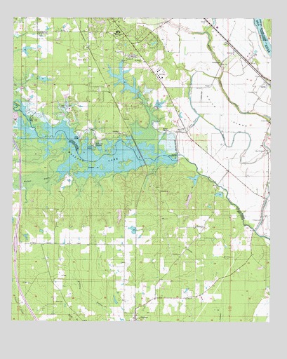
Wallace Lake, LA USGS Topographic Map
Click on map above to begin viewing in our Map Viewer.

This topographic map contains these locations and features:
Feature Name Type Latitude Longitude GNIS ID View Map
Antioch CemeteryCemeteryN32.2779°W93.6682°532181View Map
Aulds (historical)Populated PlaceN32.3693°W93.7174°552216View Map
B and S LandingLocaleN32.3257°W93.7180°541030View Map
Bethel ChurchChurchN32.2582°W93.7255°532984View Map
Caddo Parish Fire District 5 Station 1BuildingN32.3742°W93.6738°2672861View Map
Chico BayouGutN32.3332°W93.6566°533908View Map
Chico IslandIslandN32.3368°W93.6485°533909View Map
Daisy Grove School (historical)SchoolN32.3571°W93.6499°541033View Map
De Broeck LandingPopulated PlaceN32.3227°W93.7096°543131View Map
De Soto (historical)Populated PlaceN32.2913°W93.6905°545605View Map
Elizabeth ChurchChurchN32.2893°W93.6574°534795View Map
Ellerbe FieldAirportN32.3035°W93.6365°2717355View Map
Ellerbe WoodsPopulated PlaceN32.3704°W93.7043°552265View Map
Evergreen ChurchChurchN32.3571°W93.6499°534871View Map
Friendship ChurchChurchN32.3588°W93.6935°535125View Map
FriersonPopulated PlaceN32.2518°W93.6899°554489View Map
Gandy BayouStreamN32.2899°W93.6377°535164View Map
GaylesPopulated PlaceN32.3479°W93.6260°535197View Map
Good Hope ChurchChurchN32.2607°W93.6630°535274View Map
Great Elizabeth ChurchChurchN32.3293°W93.6663°535373View Map
Heinsohns Airfield (historical)AirportN32.2668°W93.7252°1632938View Map
Holy Angels SchoolSchoolN32.3693°W93.6985°535752View Map
Kelly BayouGutN32.3315°W93.6624°536161View Map
Kervin BranchStreamN32.3090°W93.6555°536178View Map
Leonard ChapelChurchN32.3329°W93.6257°536406View Map
Mary Evergreen ChurchChurchN32.3210°W93.6266°536926View Map
Mount Pleasant ChurchChurchN32.3579°W93.6885°537398View Map
NaylorPopulated PlaceN32.3479°W93.6538°543509View Map
Naylor AirportAirportN32.3460°W93.6586°1632929View Map
New Light ChurchChurchN32.3596°W93.6910°537607View Map
New Light Church (historical)ChurchN32.3232°W93.6277°541032View Map
NortonPopulated PlaceN32.3332°W93.6966°543538View Map
Palmer LandingPopulated PlaceN32.3279°W93.6766°543564View Map
Parish Governing Authority District 9CivilN32.3271°W93.6377°1930264View Map
Pleasant Hill ChurchChurchN32.3577°W93.7141°538260View Map
Ravenwood School (historical)SchoolN32.3218°W93.6460°541031View Map
RobsonPopulated PlaceN32.3618°W93.6430°541177View Map
Saint Abraham ChurchChurchN32.3449°W93.6321°538786View Map
Saint Davis ChurchChurchN32.2924°W93.6305°538830View Map
Saint Elizabeth ChurchChurchN32.3040°W93.6791°538838View Map
Shadow Pine EstatesPopulated PlaceN32.3377°W93.6946°552418View Map
Shreveport Fire Department Station 22BuildingN32.3556°W93.7281°2672850View Map
Springfield CemeteryCemeteryN32.3688°W93.7363°539602View Map
Wallace BayouStreamN32.2879°W93.6330°540204View Map
Wallace LakeReservoirN32.3273°W93.6890°556884View Map
Wallace Lake DamDamN32.3232°W93.6707°556353View Map
WildoakPopulated PlaceN32.3640°W93.7016°552474View Map

Note: Coordinates in the location and feature list above are referenced to NAD83 datum.


Copyright (C) 2008-2024 Ryan Niemi / Sunset Dynamics ... All Rights Reserved