TopoQuest Logo
Do you find TopoQuest useful?
Help keep TopoQuest running and adding new maps/features by donating!
Bitcoin:  19c7KJd3qBynnjoSw5npx9KScwjBe4ifkT
Litecoin:  LXs6TkuXGGXo1vDsWCkWVdjQX94eUKd6ui
Home View Maps Find Maps Find Places Resources & Links


Elrod, Alabama Topographic Map

USGS Map Title: Elrod, AL
USGS Map MRC: 33087C7
DRG (GeoTIFF) Download: o33087c7.tif


Neighboring USGS Topographic Map Quads:


  Palmetto, AL  
33087D8
 

  Brownville, AL  
33087D7
 

  Gin Creek, AL  
33087D6
 

  Gordo, AL  
33087C8
 

  Elrod, AL  
33087C7
 

  Lake Lurleen, AL  
33087C6
 

  Kirk, AL  
33087B8
 

  Romulus, AL  
33087B7
 

  Coker, AL  
33087B6


Map MRC Location:

N34°
W88°
N34°
W87°
H8 H7 H6 H5 H4 H3 H2 H1
G8 G7 G6 G5 G4 G3 G2 G1
F8 F7 F6 F5 F4 F3 F2 F1
E8 E7 E6 E5 E4 E3 E2 E1
D8 D7 D6 D5 D4 D3 D2 D1
C8 C7 C6 C5 C4 C3 C2 C1
B8 B7 B6 B5 B4 B3 B2 B1
A8 A7 A6 A5 A4 A3 A2 A1
N33°
W88°
N33°
W87°

Elrod, AL USGS 1:24K Topographic Map Preview:
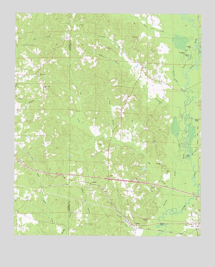
Elrod, AL USGS Topographic Map
Click on map above to begin viewing in our Map Viewer.

This topographic map contains these locations and features:
Feature Name Type Latitude Longitude GNIS ID View Map
Bethlehem Primitive Baptist ChurchChurchN33.2907°W87.7767°157892View Map
Box CreekStreamN33.2682°W87.7756°158790View Map
BuhlPopulated PlaceN33.2571°W87.7528°115168View Map
Buhl Baptist ChurchChurchN33.2557°W87.7506°157816View Map
Buhl Elementary SchoolSchoolN33.2557°W87.7517°147920View Map
Buhl Post OfficePost OfficeN33.2567°W87.7522°169134View Map
Cleveland CreekStreamN33.3118°W87.7650°116256View Map
Cleveland Ferry (historical)CrossingN33.3321°W87.7617°147992View Map
Coldwater PondLakeN33.3594°W87.7642°116401View Map
Collard PondLakeN33.3523°W87.7580°116422View Map
Cooper SloughStreamN33.2912°W87.7633°116587View Map
Corinth Baptist ChurchChurchN33.2829°W87.8106°116636View Map
Corinth CemeteryCemeteryN33.2826°W87.8100°148010View Map
Crossland (historical)LocaleN33.3293°W87.7750°148040View Map
Dennis Springer CemeteryCemeteryN33.3032°W87.7745°1700472View Map
Duck PondLakeN33.2965°W87.7591°117619View Map
Dunn CreekStreamN33.3407°W87.7608°158817View Map
Dunns Creek CemeteryCemeteryN33.3598°W87.7933°148071View Map
Dunns Creek Missionary Baptist ChurchChurchN33.3607°W87.7933°117678View Map
Dunns Creek School (historical)SchoolN33.3604°W87.7936°148072View Map
EcholaPopulated PlaceN33.3448°W87.7895°117845View Map
Echola Post OfficePost OfficeN33.3457°W87.7895°169150View Map
Echola Volunteer Fire DepartmentBuildingN33.3461°W87.7896°2683277View Map
Eightmile BranchStreamN33.3460°W87.8020°117889View Map
Elbert (historical)LocaleN33.3246°W87.7522°148095View Map
ElrodPopulated PlaceN33.2562°W87.7922°117963View Map
Elrod Baptist ChurchChurchN33.2554°W87.7975°154805View Map
Elrod Post OfficePost OfficeN33.2788°W87.8004°2789096View Map
Elrod-Moores Bridge-Echola DivisionCivilN33.3560°W87.8042°165975View Map
Freeman CemeteryCemeteryN33.3684°W87.8286°118624View Map
George BranchStreamN33.3035°W87.8058°118899View Map
Grindle PondLakeN33.3566°W87.7567°119424View Map
Harless LakeReservoirN33.2880°W87.7881°131402View Map
Harless Lake DamDamN33.2885°W87.7867°131401View Map
Hodge LakeLakeN33.3157°W87.7541°120169View Map
HolmanPopulated PlaceN33.2798°W87.8233°156489View Map
Holman ChurchChurchN33.2773°W87.8236°154806View Map
Horse CreekStreamN33.2671°W87.7742°120404View Map
Mount Nebo Baptist ChurchChurchN33.2596°W87.7850°123273View Map
Mount Nebo CemeteryCemeteryN33.2587°W87.7856°158742View Map
Mud CreekStreamN33.3679°W87.7533°123550View Map
Oak Log SloughLakeN33.3371°W87.7672°124121View Map
Old Dunn Creek CemeteryCemeteryN33.3601°W87.7958°158748View Map
Pleasant Grove CemeteryCemeteryN33.3407°W87.8586°138757View Map
Pleasant Grove ChurchChurchN33.3401°W87.8586°124959View Map
Poe BranchStreamN33.3004°W87.7956°125074View Map
Sand Springs CemeteryCemeteryN33.3323°W87.8542°138759View Map
Sand Springs ChurchChurchN33.3332°W87.8550°126333View Map
Sherman ChapelChurchN33.2576°W87.8020°1700482View Map
Shirley BridgeBridgeN33.3318°W87.7617°126778View Map
Sipsey Valley Volunteer Fire Department Buhl StationBuildingN33.2565°W87.7528°2683385View Map
Sipsey Valley Volunteer Fire Department Elrod StationBuildingN33.2557°W87.7925°2683378View Map
Springer CemeteryCemeteryN33.2865°W87.7731°127277View Map
Springer SloughStreamN33.2640°W87.7725°127278View Map
Wards Mill CreekStreamN33.2946°W87.7570°158949View Map
Wilburn CemeteryCemeteryN33.3012°W87.8153°128951View Map

Note: Coordinates in the location and feature list above are referenced to NAD83 datum.


Copyright (C) 2008-2024 Ryan Niemi / Sunset Dynamics ... All Rights Reserved