TopoQuest Logo
Do you find TopoQuest useful?
Help keep TopoQuest running and adding new maps/features by donating!
Bitcoin:  19c7KJd3qBynnjoSw5npx9KScwjBe4ifkT
Litecoin:  LXs6TkuXGGXo1vDsWCkWVdjQX94eUKd6ui
Home View Maps Find Maps Find Places Resources & Links


Gordo, Alabama Topographic Map

USGS Map Title: Gordo, AL
USGS Map MRC: 33087C8
DRG (GeoTIFF) Download: o33087c8.tif


Neighboring USGS Topographic Map Quads:


  Reform, AL  
33088D1
 

  Palmetto, AL  
33087D8
 

  Brownville, AL  
33087D7
 

  Carrollton, AL  
33088C1
 

  Gordo, AL  
33087C8
 

  Elrod, AL  
33087C7
 

  Cunningham, AL  
33088B1
 

  Kirk, AL  
33087B8
 

  Romulus, AL  
33087B7


Map MRC Location:

N34°
W88°
N34°
W87°
H8 H7 H6 H5 H4 H3 H2 H1
G8 G7 G6 G5 G4 G3 G2 G1
F8 F7 F6 F5 F4 F3 F2 F1
E8 E7 E6 E5 E4 E3 E2 E1
D8 D7 D6 D5 D4 D3 D2 D1
C8 C7 C6 C5 C4 C3 C2 C1
B8 B7 B6 B5 B4 B3 B2 B1
A8 A7 A6 A5 A4 A3 A2 A1
N33°
W88°
N33°
W87°

Gordo, AL USGS 1:24K Topographic Map Preview:
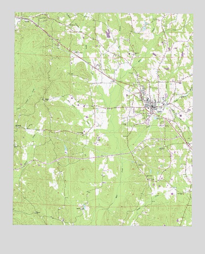
Gordo, AL USGS Topographic Map
Click on map above to begin viewing in our Map Viewer.

This topographic map contains these locations and features:
Feature Name Type Latitude Longitude GNIS ID View Map
Arbor Spring School (historical)SchoolN33.3032°W87.9528°135461View Map
Arbor Springs CemeteryCemeteryN33.3029°W87.9525°138727View Map
Arbor Springs ChurchChurchN33.3040°W87.9525°113197View Map
Bad Luck CreekStreamN33.3062°W87.9297°113334View Map
BellPopulated PlaceN33.3390°W87.9606°156044View Map
BosticPopulated PlaceN33.3037°W87.9495°138731View Map
Browns ChapelChurchN33.3237°W87.9781°158798View Map
Browns Chapel CemeteryCemeteryN33.3237°W87.9789°138732View Map
Center Springs CemeteryCemeteryN33.2771°W87.9011°115870View Map
Center Springs Church (historical)ChurchN33.2760°W87.8995°135488View Map
Center-Elmore Memorial Methodist ChurchChurchN33.2798°W87.9070°117957View Map
Church of ChristChurchN33.3479°W87.9520°138734View Map
Clear CreekStreamN33.3621°W87.9020°116227View Map
Ebenezer CemeteryCemeteryN33.2576°W87.9839°138737View Map
Ebenezer ChurchChurchN33.2573°W87.9836°117826View Map
Elmore CemeteryCemeteryN33.2862°W87.9128°135514View Map
Elmore ChurchChurchN33.2860°W87.9131°117958View Map
Fellowship CemeteryCemeteryN33.3673°W87.9611°135517View Map
Fellowship ChurchChurchN33.3671°W87.9620°118247View Map
First Baptist Church of GordoChurchN33.3221°W87.9045°149787View Map
First United Methodist Church of GordoChurchN33.3221°W87.9028°149788View Map
Glen Echo CemeteryCemeteryN33.2965°W87.9992°138742View Map
Glen Echo ChurchChurchN33.2965°W87.9989°119026View Map
Glen Echo School (historical)SchoolN33.2965°W87.9986°135527View Map
GordoPopulated PlaceN33.3201°W87.9028°119169View Map
Gordo Church of God of ProphecyChurchN33.3310°W87.9145°149789View Map
Gordo City CemeteryCemeteryN33.3259°W87.9033°138743View Map
Gordo Elementary SchoolSchoolN33.3215°W87.8956°135530View Map
Gordo High SchoolSchoolN33.3243°W87.9070°135531View Map
Gordo Police DepartmentBuildingN33.3190°W87.9031°2751858View Map
Gordo Post OfficePost OfficeN33.3226°W87.9106°166724View Map
Gordo Public LibraryBuildingN33.3173°W87.9028°149790View Map
Gordo Volunteer Fire DepartmentBuildingN33.3198°W87.9021°2682871View Map
Greenhill Memorial GardensCemeteryN33.3521°W87.9586°119364View Map
Greenhill Memorial GardensCemeteryN33.3515°W87.9581°135532View Map
Hargrove CemeteryCemeteryN33.3507°W87.9161°138745View Map
Hargrove School (historical)SchoolN33.3604°W87.9189°135536View Map
Hargrove United Methodist ChurchChurchN33.3512°W87.9156°119733View Map
Hickory Ridge Church (historical)ChurchN33.2610°W87.9039°135543View Map
Hog BranchStreamN33.3365°W87.9256°120186View Map
Holly CreekStreamN33.3190°W87.9331°120268View Map
Holly Springs CemeteryCemeteryN33.3071°W87.9972°138746View Map
Holly Springs ChurchChurchN33.3073°W87.9981°120282View Map
Kingdom Hall of Jehovahs WitnessesChurchN33.3351°W87.9292°149791View Map
LathropPopulated PlaceN33.3710°W87.9922°121410View Map
Lathrop Lookout TowerTowerN33.3721°W87.9781°164361View Map
Linebarge CemeteryCemeteryN33.3101°W87.9203°121673View Map
Little Bear CreekStreamN33.2923°W87.9250°121698View Map
Long BranchStreamN33.3204°W87.8939°121995View Map
Lowes DamDamN33.3585°W87.9367°131474View Map
Lowes LakeReservoirN33.3628°W87.9346°135563View Map
Mount Pleasant Baptist ChurchChurchN33.2960°W87.8975°152497View Map
Mount Pleasant Church CemeteryCemeteryN33.2962°W87.8981°135580View Map
Muddy BranchStreamN33.3268°W87.8825°123567View Map
New Home ChurchChurchN33.3357°W87.8981°135585View Map
NolandPopulated PlaceN33.2765°W87.9372°135590View Map
Noland School (historical)SchoolN33.2523°W87.9620°135591View Map
Oak Grove CemeteryCemeteryN33.2701°W87.8820°138753View Map
Oak Grove Christian Methodist Episcopal ChurchChurchN33.2693°W87.8822°152733View Map
Old Trinity CemeteryCemeteryN33.2537°W87.9658°135595View Map
Pentecostal Church of GodChurchN33.3362°W87.9292°149792View Map
Reform Country ClubLocaleN33.3740°W87.9814°135614View Map
Salem CemeteryCemeteryN33.2598°W87.9525°138758View Map
Salem ChurchChurchN33.2598°W87.9514°126245View Map
Sand Hill CemeteryCemeteryN33.3396°W87.9158°158919View Map
Thrasher CemeteryCemeteryN33.3129°W87.9736°158378View Map
Town of GordoCivilN33.3220°W87.9040°2406590View Map
WVRT-FM (Reform)TowerN33.3304°W87.9156°161180View Map
WVRT-FM (Reform)TowerN33.3335°W87.9170°161181View Map

Note: Coordinates in the location and feature list above are referenced to NAD83 datum.


Copyright (C) 2008-2025 Ryan Niemi / Sunset Dynamics ... All Rights Reserved