TopoQuest Logo
Do you find TopoQuest useful?
Help keep TopoQuest running and adding new maps/features by donating!
Bitcoin:  19c7KJd3qBynnjoSw5npx9KScwjBe4ifkT
Litecoin:  LXs6TkuXGGXo1vDsWCkWVdjQX94eUKd6ui
Home View Maps Find Maps Find Places Resources & Links


Palmetto, Alabama Topographic Map

USGS Map Title: Palmetto, AL
USGS Map MRC: 33087D8
DRG (GeoTIFF) Download: o33087d8.tif


Neighboring USGS Topographic Map Quads:


  Millport, AL  
33088E1
 

  Kennedy, AL  
33087E8
 

  Newtonville, AL  
33087E7
 

  Reform, AL  
33088D1
 

  Palmetto, AL  
33087D8
 

  Brownville, AL  
33087D7
 

  Carrollton, AL  
33088C1
 

  Gordo, AL  
33087C8
 

  Elrod, AL  
33087C7


Map MRC Location:

N34°
W88°
N34°
W87°
H8 H7 H6 H5 H4 H3 H2 H1
G8 G7 G6 G5 G4 G3 G2 G1
F8 F7 F6 F5 F4 F3 F2 F1
E8 E7 E6 E5 E4 E3 E2 E1
D8 D7 D6 D5 D4 D3 D2 D1
C8 C7 C6 C5 C4 C3 C2 C1
B8 B7 B6 B5 B4 B3 B2 B1
A8 A7 A6 A5 A4 A3 A2 A1
N33°
W88°
N33°
W87°

Palmetto, AL USGS 1:24K Topographic Map Preview:
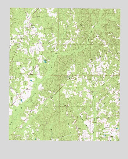
Palmetto, AL USGS Topographic Map
Click on map above to begin viewing in our Map Viewer.

This topographic map contains these locations and features:
Feature Name Type Latitude Longitude GNIS ID View Map
Beaver CreekStreamN33.4284°W87.9695°113719View Map
Big Hill CemeteryCemeteryN33.4740°W87.9003°138730View Map
Big Hill ChurchChurchN33.4743°W87.9017°114284View Map
Carroll School (historical)SchoolN33.4415°W87.9159°135480View Map
Crossroads School (historical)SchoolN33.4721°W87.9736°135506View Map
Double Branches ChurchChurchN33.4290°W87.9050°117412View Map
Doublebranches CemeteryCemeteryN33.4279°W87.9039°159011View Map
Duck BranchStreamN33.4554°W87.9514°117610View Map
Duck BranchStreamN33.4823°W87.9011°117611View Map
Elmore CreekStreamN33.4193°W87.9036°117959View Map
FairviewPopulated PlaceN33.3787°W87.8856°118128View Map
Gordo DivisionCivilN33.3983°W87.8926°165925View Map
Hannah CemeteryCemeteryN33.3979°W87.8761°138744View Map
Hannah ChurchChurchN33.3984°W87.8770°119685View Map
Harper BranchStreamN33.4021°W87.9031°119768View Map
Harpers Mill (historical)LocaleN33.4134°W87.8956°135537View Map
Higdon BranchStreamN33.4576°W87.9478°120046View Map
Koon BranchStreamN33.3765°W87.9028°121283View Map
Linebarger BranchStreamN33.3998°W87.9906°121674View Map
Marvin Hill CemeteryCemeteryN33.4840°W87.9181°138750View Map
Marvin Hill ChurchChurchN33.4840°W87.9189°122350View Map
Mount Tabor CemeteryCemeteryN33.4918°W87.9703°152512View Map
Mount Tabor ChurchChurchN33.4862°W87.9786°135582View Map
Mullican BranchStreamN33.3798°W87.9039°123584View Map
New Hope CemeteryCemeteryN33.4071°W87.9347°138752View Map
New Hope ChurchChurchN33.4082°W87.9356°123829View Map
New Salem ChurchChurchN33.4376°W87.9781°123904View Map
No Head BranchStreamN33.3754°W87.9639°112864View Map
Old Salem CemeteryCemeteryN33.4479°W87.9795°158371View Map
Orrs LakeReservoirN33.4496°W87.9598°124308View Map
Orrs Lake DamDamN33.4484°W87.9584°131544View Map
PalmettoPopulated PlaceN33.4840°W87.9778°124391View Map
Palmetto School (historical)SchoolN33.4857°W87.9778°135596View Map
Palmetto Volunteer Fire DepartmentBuildingN33.4847°W87.9749°2683182View Map
Shiloh CemeteryCemeteryN33.3957°W87.8989°138760View Map
Shiloh ChurchChurchN33.3965°W87.8992°126747View Map
Thornton BranchStreamN33.4790°W87.8934°135635View Map
Unity Grove CemeteryCemeteryN33.4709°W87.9942°158622View Map
Unity Grove Christian Methodist Episcopal ChurchChurchN33.4709°W87.9953°158944View Map
Unity Grove Lower CemeteryCemeteryN33.4793°W87.9756°138765View Map
Unity Grove Methodist ChurchChurchN33.4801°W87.9759°158984View Map
Unity Grove Upper CemeteryCemeteryN33.4815°W87.9739°138766View Map
Wild Goose CreekStreamN33.3862°W87.9992°128958View Map
ZionPopulated PlaceN33.4212°W87.8775°129326View Map
Zion CemeteryCemeteryN33.4246°W87.8792°138767View Map
Zion Primitive Baptist ChurchChurchN33.4246°W87.8789°154111View Map
Zion Volunteer Fire DepartmentBuildingN33.4224°W87.8760°2683132View Map

Note: Coordinates in the location and feature list above are referenced to NAD83 datum.


Copyright (C) 2008-2025 Ryan Niemi / Sunset Dynamics ... All Rights Reserved