TopoQuest Logo
Do you find TopoQuest useful?
Help keep TopoQuest running and adding new maps/features by donating!
Bitcoin:  19c7KJd3qBynnjoSw5npx9KScwjBe4ifkT
Litecoin:  LXs6TkuXGGXo1vDsWCkWVdjQX94eUKd6ui
Home View Maps Find Maps Find Places Resources & Links


Embden Pond, Maine Topographic Map

USGS Map Title: Embden Pond, ME
USGS Map MRC: 44069H8
DRG (GeoTIFF) Download: o44069h8.tif


Neighboring USGS Topographic Map Quads:


  Witham Mountain, ME  
45070A1
 

  Bingham, ME  
45069A8
 

  Mahoney Hill, ME  
45069A7
 

  New Portland, ME  
44070H1
 

  Embden Pond, ME  
44069H8
 

  Solon, ME  
44069H7
 

  New Vineyard, ME  
44070G1
 

  Madison West, ME  
44069G8
 

  Madison East, ME  
44069G7


Map MRC Location:

N45°
W70°
N45°
W69°
H8 H7 H6 H5 H4 H3 H2 H1
G8 G7 G6 G5 G4 G3 G2 G1
F8 F7 F6 F5 F4 F3 F2 F1
E8 E7 E6 E5 E4 E3 E2 E1
D8 D7 D6 D5 D4 D3 D2 D1
C8 C7 C6 C5 C4 C3 C2 C1
B8 B7 B6 B5 B4 B3 B2 B1
A8 A7 A6 A5 A4 A3 A2 A1
N44°
W70°
N44°
W69°

Embden Pond, ME USGS 1:24K Topographic Map Preview:
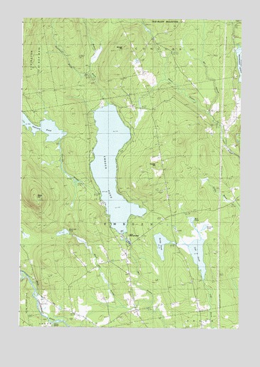
Embden Pond, ME USGS Topographic Map
Click on map above to begin viewing in our Map Viewer.

This topographic map contains these locations and features:
Feature Name Type Latitude Longitude GNIS ID View Map
Black HillSummitN44.9270°W69.9915°562439View Map
Black Hill PondLakeN44.9132°W69.9755°562440View Map
Black Hill StreamStreamN44.8853°W69.9245°562441View Map
Boynton PondLakeN44.9160°W69.8950°562829View Map
Concord Corner CemeteryCemeteryN44.9785°W69.9312°2727471View Map
Deveraux Camps (historical)LocaleN44.9251°W69.9528°579061View Map
Dunbar HillSummitN44.9410°W69.9225°565397View Map
Ela Rearing StationLocaleN44.9112°W69.9398°1908534View Map
Embden Elementary School (historical)SchoolN44.9020°W69.9387°1908535View Map
Embden PondReservoirN44.9404°W69.9480°565892View Map
Embden Pond DamDamN44.9134°W69.9408°1774739View Map
Emerson School (historical)SchoolN44.9020°W69.9420°579063View Map
Fahi PondReservoirN44.9056°W69.8985°565988View Map
Fahi Pond DamDamN44.8946°W69.8952°1774737View Map
Hancock PondLakeN44.9540°W69.9818°567563View Map
Hancock PondReservoirN44.9510°W69.9772°1774742View Map
Hancock Pond DamDamN44.9510°W69.9772°1774741View Map
Hancock StreamStreamN44.9287°W69.9534°567564View Map
Hilton BrookStreamN44.8770°W69.9801°561010View Map
Hunniwell BrookStreamN44.9770°W69.9603°568460View Map
Hutchins BrookStreamN44.8951°W69.9962°568527View Map
Martin StreamStreamN44.9620°W69.8920°570861View Map
Mud PondLakeN44.9187°W69.9014°571906View Map
North New Portland FairgroundsLocaleN44.8851°W69.9853°1908634View Map
Old Bluff MountainSummitN44.9967°W69.9181°572686View Map
Sandy PondLakeN44.9089°W69.9193°574888View Map
Savage HillSummitN44.9873°W69.9418°574944View Map
Savage Hill CemeteryCemeteryN44.9873°W69.9377°2737040View Map
Town of EmbdenCivilN44.9248°W69.9317°582466View Map
Witham BrookStreamN44.9651°W69.9498°578624View Map

Note: Coordinates in the location and feature list above are referenced to NAD83 datum.


Copyright (C) 2008-2025 Ryan Niemi / Sunset Dynamics ... All Rights Reserved