TopoQuest Logo
Do you find TopoQuest useful?
Help keep TopoQuest running and adding new maps/features by donating!
Bitcoin:  19c7KJd3qBynnjoSw5npx9KScwjBe4ifkT
Litecoin:  LXs6TkuXGGXo1vDsWCkWVdjQX94eUKd6ui
Home View Maps Find Maps Find Places Resources & Links


Halifax, Pennsylvania Topographic Map

USGS Map Title: Halifax, PA
USGS Map MRC: 40076D8
DRG (GeoTIFF) Download: o40076d8.tif


Neighboring USGS Topographic Map Quads:


  Reward, PA  
40077E1
 

  Millersburg, PA  
40076E8
 

  Elizabethville, PA  
40076E7
 

  Duncannon, PA  
40077D1
 

  Halifax, PA  
40076D8
 

  Enders, PA  
40076D7
 

  Wertzville, PA  
40077C1
 

  Harrisburg West, PA  
40076C8
 

  Harrisburg East, PA  
40076C7


Map MRC Location:

N41°
W77°
N41°
W76°
H8 H7 H6 H5 H4 H3 H2 H1
G8 G7 G6 G5 G4 G3 G2 G1
F8 F7 F6 F5 F4 F3 F2 F1
E8 E7 E6 E5 E4 E3 E2 E1
D8 D7 D6 D5 D4 D3 D2 D1
C8 C7 C6 C5 C4 C3 C2 C1
B8 B7 B6 B5 B4 B3 B2 B1
A8 A7 A6 A5 A4 A3 A2 A1
N40°
W77°
N40°
W76°

Halifax, PA USGS 1:24K Topographic Map Preview:
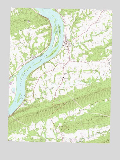
Halifax, PA USGS Topographic Map
Click on map above to begin viewing in our Map Viewer.

This topographic map contains these locations and features:
Feature Name Type Latitude Longitude GNIS ID View Map
Armstrong CreekStreamN40.4818°W76.9336°1168401View Map
Borough of HalifaxCivilN40.4672°W76.9287°1215161View Map
Borough of New BuffaloCivilN40.4543°W76.9705°1215529View Map
Bressler IslandIslandN40.4593°W76.9453°1170206View Map
Buffalo CreekStreamN40.4518°W76.9716°1170601View Map
Camp HebronLocaleN40.4320°W76.8897°1171018View Map
Clemson IslandIslandN40.4706°W76.9433°1171987View Map
Dauphin - Middle Paxton Fire Company 1 Station 38BuildingN40.3764°W76.9316°2653067View Map
Dunkle SchoolSchoolN40.4859°W76.9253°1197067View Map
Fetterhoff ChurchChurchN40.4881°W76.8936°1174722View Map
Fisherville Volunteer Fire Company Station 216BuildingN40.4996°W76.8845°2653061View Map
Girtys NotchPillarN40.4737°W76.9536°1201337View Map
Grace ChurchChurchN40.4054°W76.9128°1175898View Map
Gurdy RunStreamN40.4929°W76.9378°1176323View Map
Half FallsPopulated PlaceN40.4887°W76.9516°1203741View Map
HalifaxPopulated PlaceN40.4681°W76.9319°1176391View Map
Halifax Area Ambulance and Rescue Station 13BuildingN40.4703°W76.9218°2722120View Map
Halifax Area Elementary SchoolSchoolN40.4634°W76.9330°1208384View Map
Halifax Area High SchoolSchoolN40.4618°W76.9289°1208385View Map
Halifax Fire Department Station 29BuildingN40.4498°W76.9315°2652924View Map
Halifax Police DepartmentBuildingN40.4696°W76.9318°2754590View Map
Halifax Post OfficePost OfficeN40.4697°W76.9320°2772730View Map
Highland CemeteryCemeteryN40.3762°W76.9999°1177026View Map
Hill ChurchChurchN40.4643°W76.9786°1177069View Map
InglenookPopulated PlaceN40.4131°W76.9811°1203873View Map
Jacobs ChurchChurchN40.4498°W76.8783°1177955View Map
Lingle IslandIslandN40.4804°W76.9386°1179427View Map
MatamorasPopulated PlaceN40.4401°W76.9333°1180540View Map
Medical Express Ambulance ServiceBuildingN40.4482°W76.9299°2722122View Map
Montgomery FerryPopulated PlaceN40.4990°W76.9728°1181461View Map
MWIS Site Number Six-Anthracite ReservoirReservoirN40.4534°W76.9847°1194820View Map
New BuffaloPopulated PlaceN40.4543°W76.9697°1182295View Map
New Buffalo Post OfficePost OfficeN40.4543°W76.9720°2773224View Map
New England RunStreamN40.4809°W76.9247°1182311View Map
Newkirk Pond DamDamN40.4534°W76.9847°1194821View Map
Pennsylvania State Police StationLocaleN40.4645°W76.9530°1197857View Map
Peters Mountain OverlookLocaleN40.4034°W76.9247°1207169View Map
Powells CreekStreamN40.4104°W76.9844°1184368View Map
Powells ValleyPopulated PlaceN40.4334°W76.9330°1184371View Map
Powells Valley ChurchChurchN40.4423°W76.8941°1184372View Map
Rutter School (historical)SchoolN40.4823°W76.9028°1197856View Map
Shammos SchoolSchoolN40.4393°W76.9558°1197854View Map
SingersvillePopulated PlaceN40.3773°W76.9116°1187714View Map
State Game Lands Number 254ParkN40.4923°W76.9630°1188506View Map
Stone GlenPopulated PlaceN40.3848°W76.8872°1188719View Map
Tallman West AirportAirportN40.3966°W76.9413°2443656View Map
Township of HalifaxCivilN40.4698°W76.9267°1216356View Map
Township of Middle PaxtonCivilN40.3935°W76.8754°1216363View Map
Township of ReedCivilN40.4123°W76.9901°1216365View Map
Township of WattsCivilN40.4638°W76.9923°1216955View Map
Victoria FurnacePopulated PlaceN40.4165°W76.8758°1205093View Map
Volunteer Fire Company 1 of New BuffaloBuildingN40.4505°W76.9790°2645915View Map
Walsh Airport (historical)AirportN40.4501°W76.9664°1193989View Map
WaynesvillePopulated PlaceN40.4523°W76.8791°1190726View Map
Wesleyan ChurchChurchN40.4793°W76.9878°1190868View Map
West Fall IslandIslandN40.4162°W76.9878°1191020View Map
Zion CemeteryCemeteryN40.3845°W76.9374°1191962View Map
Zion ChurchChurchN40.3870°W76.9466°1191987View Map

Note: Coordinates in the location and feature list above are referenced to NAD83 datum.


Copyright (C) 2008-2025 Ryan Niemi / Sunset Dynamics ... All Rights Reserved