TopoQuest Logo
Do you find TopoQuest useful?
Help keep TopoQuest running and adding new maps/features by donating!
Bitcoin:  19c7KJd3qBynnjoSw5npx9KScwjBe4ifkT
Litecoin:  LXs6TkuXGGXo1vDsWCkWVdjQX94eUKd6ui
Home View Maps Find Maps Find Places Resources & Links


Entriken, Pennsylvania Topographic Map

USGS Map Title: Entriken, PA
USGS Map MRC: 40078C2
DRG (GeoTIFF) Download: o40078c2.tif


Neighboring USGS Topographic Map Quads:


  Frankstown, PA  
40078D3
 

  Williamsburg, PA  
40078D2
 

  Huntingdon, PA  
40078D1
 

  Martinsburg, PA  
40078C3
 

  Entriken, PA  
40078C2
 

  Cassville, PA  
40078C1
 

  Hopewell, PA  
40078B3
 

  Saxton, PA  
40078B2
 

  Saltillo, PA  
40078B1


Map MRC Location:

N41°
W79°
N41°
W78°
H8 H7 H6 H5 H4 H3 H2 H1
G8 G7 G6 G5 G4 G3 G2 G1
F8 F7 F6 F5 F4 F3 F2 F1
E8 E7 E6 E5 E4 E3 E2 E1
D8 D7 D6 D5 D4 D3 D2 D1
C8 C7 C6 C5 C4 C3 C2 C1
B8 B7 B6 B5 B4 B3 B2 B1
A8 A7 A6 A5 A4 A3 A2 A1
N40°
W79°
N40°
W78°

Entriken, PA USGS 1:24K Topographic Map Preview:
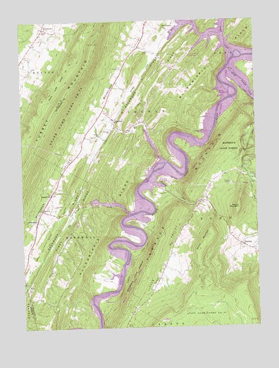
Entriken, PA USGS Topographic Map
Click on map above to begin viewing in our Map Viewer.

This topographic map contains these locations and features:
Feature Name Type Latitude Longitude GNIS ID View Map
AitchPopulated PlaceN40.3742°W78.1592°1168102View Map
Allegrippis RidgeRidgeN40.3442°W78.1608°1192065View Map
Backbone RidgeRidgeN40.2906°W78.2311°1168562View Map
Balanced RockSummitN40.3226°W78.1308°1168622View Map
BeavertownPopulated PlaceN40.3723°W78.2370°1169070View Map
Brumbaugh CemeteryCemeteryN40.3264°W78.2130°1170430View Map
Bunns MountainSummitN40.2873°W78.1508°1170693View Map
Camp ReynoldsLocaleN40.3062°W78.1817°1171070View Map
CherrytownPopulated PlaceN40.2940°W78.2417°1171688View Map
Church CampLocaleN40.3112°W78.1739°1171847View Map
Coffee RunStreamN40.3170°W78.1728°1172129View Map
Coffee Run OverlookLocaleN40.3184°W78.1772°1206542View Map
CoveLocaleN40.2681°W78.2470°1172519View Map
DrabLocaleN40.3715°W78.2370°1201262View Map
EntrikenPopulated PlaceN40.3340°W78.1989°1174284View Map
Entriken Bridge OverlookLocaleN40.3126°W78.1847°1206543View Map
Entriken CemeteryCemeteryN40.3288°W78.2077°1174285View Map
Entriken ChurchChurchN40.3298°W78.2020°1174286View Map
Fouses Airport (historical)AirportN40.3667°W78.1664°1193956View Map
FoxtonPopulated PlaceN40.2651°W78.2458°1201261View Map
Great Trough CreekStreamN40.3556°W78.1383°1176042View Map
James CreekStreamN40.3617°W78.1347°1177976View Map
James Creek Access AreaAreaN40.3617°W78.1581°1200923View Map
Lake Raytown Resort Rothrock MarinaLocaleN40.2954°W78.1808°1207543View Map
Lick RunLocaleN40.2792°W78.1275°1201258View Map
Lincoln Grange HallBuildingN40.3554°W78.1950°1214733View Map
Little ValleyValleyN40.2994°W78.1582°1179703View Map
Little Valley CemeteryCemeteryN40.2677°W78.1788°2026381View Map
Nancys CampgroundLocaleN40.3451°W78.1422°1200742View Map
NewburgPopulated PlaceN40.2834°W78.1325°1182385View Map
Newburg CemeteryCemeteryN40.2848°W78.1325°1844212View Map
Paradise FurnacePopulated PlaceN40.3123°W78.1253°1204358View Map
Pee Wee IslandIslandN40.3704°W78.1420°1202510View Map
Peninsula CampgroundLocaleN40.2834°W78.1997°1200749View Map
Piney RidgeRidgeN40.3181°W78.2047°1193137View Map
Plummer Family CemeteryCemeteryN40.2809°W78.1294°2026382View Map
Putts CampgroundLocaleN40.2617°W78.2081°1200750View Map
Rothrock CampgroundLocaleN40.2934°W78.1931°1200748View Map
Round MountainSummitN40.2987°W78.1342°1185534View Map
RussellvillePopulated PlaceN40.3054°W78.2336°1185659View Map
Russellville ChurchChurchN40.2981°W78.2389°1185660View Map
Russellville Methodist CemeteryCemeteryN40.3013°W78.2373°1813169View Map
Russellville Reformed CemeteryCemeteryN40.3062°W78.2339°1813168View Map
Salem Reformed CemeteryCemeteryN40.3722°W78.2367°2776384View Map
Salems ChurchChurchN40.3717°W78.2367°1186860View Map
SalterPopulated PlaceN40.2751°W78.1333°1201260View Map
Shultz CemeteryCemeteryN40.3615°W78.1816°1187629View Map
Shy Beaver Access AreaAreaN40.3001°W78.2081°1200747View Map
Shy Beaver CreekStreamN40.2965°W78.1917°1198123View Map
Tarman Run Access AreaAreaN40.3117°W78.1731°1200746View Map
Tatman RunStreamN40.3104°W78.1811°1189291View Map
Tatman Run Access AreaAreaN40.3109°W78.1778°1201883View Map
Township of HopewellCivilN40.2759°W78.2224°1216510View Map
Township of LincolnCivilN40.3371°W78.1857°1216512View Map
Trough CreekPopulated PlaceN40.2817°W78.1311°1201259View Map
Trough Creek State ParkParkN40.3287°W78.1314°1189824View Map
Trough Creek Wild AreaAreaN40.3201°W78.1497°1200745View Map
YMCA CampLocaleN40.3084°W78.1831°1207601View Map

Note: Coordinates in the location and feature list above are referenced to NAD83 datum.


Copyright (C) 2008-2025 Ryan Niemi / Sunset Dynamics ... All Rights Reserved