TopoQuest Logo
Do you find TopoQuest useful?
Help keep TopoQuest running and adding new maps/features by donating!
Bitcoin:  19c7KJd3qBynnjoSw5npx9KScwjBe4ifkT
Litecoin:  LXs6TkuXGGXo1vDsWCkWVdjQX94eUKd6ui
Home View Maps Find Maps Find Places Resources & Links


Martinsburg, Pennsylvania Topographic Map

USGS Map Title: Martinsburg, PA
USGS Map MRC: 40078C3
DRG (GeoTIFF) Download: o40078c3.tif


Neighboring USGS Topographic Map Quads:


  Hollidaysburg, PA  
40078D4
 

  Frankstown, PA  
40078D3
 

  Williamsburg, PA  
40078D2
 

  Roaring Spring, PA  
40078C4
 

  Martinsburg, PA  
40078C3
 

  Entriken, PA  
40078C2
 

  New Enterprise, PA  
40078B4
 

  Hopewell, PA  
40078B3
 

  Saxton, PA  
40078B2


Map MRC Location:

N41°
W79°
N41°
W78°
H8 H7 H6 H5 H4 H3 H2 H1
G8 G7 G6 G5 G4 G3 G2 G1
F8 F7 F6 F5 F4 F3 F2 F1
E8 E7 E6 E5 E4 E3 E2 E1
D8 D7 D6 D5 D4 D3 D2 D1
C8 C7 C6 C5 C4 C3 C2 C1
B8 B7 B6 B5 B4 B3 B2 B1
A8 A7 A6 A5 A4 A3 A2 A1
N40°
W79°
N40°
W78°

Martinsburg, PA USGS 1:24K Topographic Map Preview:
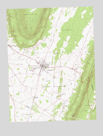
Martinsburg, PA USGS Topographic Map
Click on map above to begin viewing in our Map Viewer.

This topographic map contains these locations and features:
Feature Name Type Latitude Longitude GNIS ID View Map
Altoona Blair County Fire DepartmentBuildingN40.2961°W78.3240°2645699View Map
Altoona-Blair County AirportAirportN40.2954°W78.3238°1193918View Map
Baker-Sell AirportAirportN40.2504°W78.3585°1193898View Map
Borough of MartinsburgCivilN40.3109°W78.3241°1214943View Map
Brumbaugh CemeteryCemeteryN40.3113°W78.2785°1170429View Map
Burget CemeteryCemeteryN40.2688°W78.3157°2776330View Map
Central High SchoolSchoolN40.3062°W78.3400°1171488View Map
Clover CreekPopulated PlaceN40.3065°W78.2792°1203288View Map
CurryvillePopulated PlaceN40.2759°W78.3383°1172851View Map
Curryville Post OfficePost OfficeN40.2759°W78.3379°2777467View Map
Detwiler CemeteryCemeteryN40.3396°W78.3106°1173187View Map
Diehls Crossroads Brethren CemeteryCemeteryN40.2622°W78.3253°2776339View Map
Diehls Crossroads ChurchChurchN40.2626°W78.3247°1173264View Map
Dilling CemeteryCemeteryN40.3719°W78.2772°1173271View Map
East SharpsburgPopulated PlaceN40.3326°W78.3692°1173870View Map
East Sharpsburg CemeteryCemeteryN40.3383°W78.3691°2776343View Map
East Sharpsburg Post Office (historical)Post OfficeN40.3320°W78.3697°1782048View Map
Fairview CemeteryCemeteryN40.3149°W78.3212°1174478View Map
Folkner - Wagner CemeteryCemeteryN40.2842°W78.3082°2776347View Map
HenriettaPopulated PlaceN40.2648°W78.2972°1176838View Map
Kauffman CemeteryCemeteryN40.2804°W78.3500°2776357View Map
Kensinger CemeteryCemeteryN40.2899°W78.2827°1178378View Map
Lock MountainSummitN40.3642°W78.3217°1179750View Map
MartinsburgPopulated PlaceN40.3112°W78.3242°1180504View Map
Martinsburg Borough Police DepartmentBuildingN40.3096°W78.3217°2777119View Map
Martinsburg JunctionPopulated PlaceN40.3090°W78.3392°1180505View Map
Martinsburg Post OfficePost OfficeN40.3114°W78.3247°2777409View Map
Martinsburg Volunteer Fire Company Station 80BuildingN40.3094°W78.3257°2644800View Map
Mennonite CemeteryCemeteryN40.2976°W78.3094°1180929View Map
Middle RunStreamN40.2798°W78.2925°1181054View Map
MillerstownPopulated PlaceN40.2790°W78.2983°1181257View Map
Mount Pleasant CemeteryCemeteryN40.2748°W78.3028°2776365View Map
Mount Pleasant ChurchChurchN40.2745°W78.3025°1181815View Map
Nicodemus CemeteryCemeteryN40.2711°W78.2948°1182452View Map
Noggle CemeteryCemeteryN40.2902°W78.3719°1182497View Map
North Woodbury Township Police DepartmentBuildingN40.2904°W78.3324°2766717View Map
Phillips MemorialCemeteryN40.2603°W78.2661°1183674View Map
Rebecca Furnace CemeteryCemeteryN40.3245°W78.2592°1184741View Map
Shriver CemeteryCemeteryN40.2901°W78.2995°1187624View Map
Smith CemeteryCemeteryN40.2773°W78.2905°2776386View Map
Smithfield ChurchChurchN40.3701°W78.2950°1187899View Map
Spring Hope CemeteryCemeteryN40.3052°W78.3268°2776389View Map
State Game Lands Number 147ParkN40.3534°W78.3353°1188451View Map
Stonerook CemeteryCemeteryN40.2551°W78.3116°1188745View Map
Township of HustonCivilN40.3650°W78.2685°1215963View Map
Township of North WoodburyCivilN40.2889°W78.3068°1215966View Map
Treesh CemeteryCemeteryN40.2619°W78.3030°2776392View Map
WJSM-AM (Martinsburg)TowerN40.3040°W78.2661°1200393View Map
WJSM-FM (Martinsburg)TowerN40.3023°W78.2645°1200205View Map

Note: Coordinates in the location and feature list above are referenced to NAD83 datum.


Copyright (C) 2008-2025 Ryan Niemi / Sunset Dynamics ... All Rights Reserved