TopoQuest Logo
Do you find TopoQuest useful?
Help keep TopoQuest running and adding new maps/features by donating!
Bitcoin:  19c7KJd3qBynnjoSw5npx9KScwjBe4ifkT
Litecoin:  LXs6TkuXGGXo1vDsWCkWVdjQX94eUKd6ui
Home View Maps Find Maps Find Places Resources & Links


Hopewell, Pennsylvania Topographic Map

USGS Map Title: Hopewell, PA
USGS Map MRC: 40078B3
DRG (GeoTIFF) Download: o40078b3.tif


Neighboring USGS Topographic Map Quads:


  Roaring Spring, PA  
40078C4
 

  Martinsburg, PA  
40078C3
 

  Entriken, PA  
40078C2
 

  New Enterprise, PA  
40078B4
 

  Hopewell, PA  
40078B3
 

  Saxton, PA  
40078B2
 

  Everett West, PA  
40078A4
 

  Everett East, PA  
40078A3
 

  Wells Tannery, PA  
40078A2


Map MRC Location:

N41°
W79°
N41°
W78°
H8 H7 H6 H5 H4 H3 H2 H1
G8 G7 G6 G5 G4 G3 G2 G1
F8 F7 F6 F5 F4 F3 F2 F1
E8 E7 E6 E5 E4 E3 E2 E1
D8 D7 D6 D5 D4 D3 D2 D1
C8 C7 C6 C5 C4 C3 C2 C1
B8 B7 B6 B5 B4 B3 B2 B1
A8 A7 A6 A5 A4 A3 A2 A1
N40°
W79°
N40°
W78°

Hopewell, PA USGS 1:24K Topographic Map Preview:
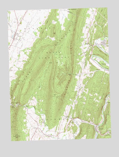
Hopewell, PA USGS Topographic Map
Click on map above to begin viewing in our Map Viewer.

This topographic map contains these locations and features:
Feature Name Type Latitude Longitude GNIS ID View Map
Abbot RidgeRidgeN40.2062°W78.2558°1168022View Map
Bank RunStreamN40.1434°W78.2958°1214661View Map
Bear RunStreamN40.2076°W78.3175°1168915View Map
Beaver CreekStreamN40.1595°W78.3739°1169009View Map
Bedford ChurchChurchN40.1412°W78.3331°1169082View Map
Bedford Forge CemeteryCemeteryN40.1409°W78.3329°2776045View Map
Borough of HopewellCivilN40.1345°W78.2666°1214898View Map
Borough of WoodburyCivilN40.2254°W78.3660°1214907View Map
Brumbaugh CemeteryCemeteryN40.1851°W78.2540°2776054View Map
Bunker Hill CemeteryCemeteryN40.1853°W78.2858°1170680View Map
Byers RidgeRidgeN40.2331°W78.3275°1170839View Map
Coot HillSummitN40.1684°W78.3175°1172433View Map
Cottles CornerPopulated PlaceN40.1367°W78.3414°1172488View Map
Dark HollowValleyN40.1591°W78.3704°1172930View Map
Dry Hill CemeteryCemeteryN40.2237°W78.3570°1173505View Map
Dry RunStreamN40.1917°W78.2556°1173527View Map
EichelbergertownPopulated PlaceN40.1431°W78.2961°1174053View Map
Eshelman CemeteryCemeteryN40.2410°W78.3552°2776075View Map
Grace ChurchChurchN40.1367°W78.3045°1175888View Map
Hickory Bottom CemeteryCemeteryN40.2342°W78.3501°2776086View Map
Homans CornerPopulated PlaceN40.2165°W78.2747°1177314View Map
HopewellPopulated PlaceN40.1356°W78.2678°1177390View Map
Hopewell CemeteryCemeteryN40.1420°W78.2753°1177393View Map
Hopewell Post OfficePost OfficeN40.1364°W78.2687°2777401View Map
Keagy CemeteryCemeteryN40.2137°W78.3733°1178262View Map
LangdondalePopulated PlaceN40.1304°W78.2539°1178866View Map
Little Jack CornersPopulated PlaceN40.1579°W78.3561°1179569View Map
Longs RunStreamN40.1323°W78.2539°1179922View Map
Loysburg GapPopulated PlaceN40.1598°W78.3658°1180054View Map
Maple RunStreamN40.1501°W78.3350°1180362View Map
Marble CityPopulated PlaceN40.1467°W78.3056°1180386View Map
MarysvillePopulated PlaceN40.1912°W78.2603°1180519View Map
Morrisons CovePopulated PlaceN40.2356°W78.3622°2652231View Map
Morrisons CoveValleyN40.2492°W78.3358°1192965View Map
Piney RidgeRidgeN40.2434°W78.2583°1183940View Map
Pulpit HillSummitN40.2267°W78.3186°1184487View Map
Raven ChurchChurchN40.1892°W78.2667°1184708View Map
Ravers GapGapN40.1879°W78.2989°1184716View Map
Ravers RunStreamN40.1931°W78.2589°1184717View Map
Raystown ChurchChurchN40.1906°W78.2547°1184731View Map
Replogle CemeteryCemeteryN40.2387°W78.3675°1184907View Map
Riddleburg Post OfficePost OfficeN40.1612°W78.2548°2775124View Map
RiddlesburgPopulated PlaceN40.1620°W78.2545°1185031View Map
Riddlesburg MountainSummitN40.1506°W78.2508°1185032View Map
River MountainSummitN40.1581°W78.2617°1185130View Map
Saint Lukes CemeteryCemeteryN40.2328°W78.2753°1186284View Map
Saint Pauls CemeteryCemeteryN40.1279°W78.3161°2776033View Map
Saint Pauls ChurchChurchN40.1265°W78.3164°1186580View Map
Sandy RunStreamN40.1312°W78.2681°1186966View Map
Sixmile RunStreamN40.1623°W78.2550°1187739View Map
Smith SchoolSchoolN40.1340°W78.3364°1187890View Map
Steele CemeteryCemeteryN40.1334°W78.3417°1188584View Map
StonerstownPopulated PlaceN40.2167°W78.2575°1188746View Map
Stonerstown CemeteryCemeteryN40.2176°W78.2572°2776168View Map
Stonerstown Census Designated PlaceCensusN40.2155°W78.2571°2630041View Map
Sugar Camp RunStreamN40.2215°W78.2536°1188927View Map
Sunny SidePopulated PlaceN40.1420°W78.2856°1189070View Map
Township of LibertyCivilN40.2101°W78.2783°1215899View Map
Township of WoodburyCivilN40.2292°W78.3509°1215911View Map
Tussey MountainRangeN40.1912°W78.3467°1193568View Map
Warriors Path State ParkParkN40.1959°W78.2564°1190610View Map
WoodburyPopulated PlaceN40.2265°W78.3667°1191721View Map
Woodbury Mennonite Church CemeteryCemeteryN40.2172°W78.3627°2776178View Map
Woodbury Post OfficePost OfficeN40.2253°W78.3671°2777466View Map
Yellow CreekPopulated PlaceN40.1304°W78.3314°1191872View Map
Yellow CreekStreamN40.1379°W78.2700°1190970View Map
Yellow Creek Post Office (historical)Post OfficeN40.1304°W78.3314°1214502View Map

Note: Coordinates in the location and feature list above are referenced to NAD83 datum.


Copyright (C) 2008-2024 Ryan Niemi / Sunset Dynamics ... All Rights Reserved