TopoQuest Logo
Do you find TopoQuest useful?
Help keep TopoQuest running and adding new maps/features by donating!
Bitcoin:  19c7KJd3qBynnjoSw5npx9KScwjBe4ifkT
Litecoin:  LXs6TkuXGGXo1vDsWCkWVdjQX94eUKd6ui
Home View Maps Find Maps Find Places Resources & Links


Fairdealing, Kentucky Topographic Map

USGS Map Title: Fairdealing, KY
USGS Map MRC: 36088G2
DRG (GeoTIFF) Download: o36088g2.tif


Neighboring USGS Topographic Map Quads:


  Briensburg, KY  
36088H3
 

  Birmingham Point, KY  
36088H2
 

  Mont, KY  
36088H1
 

  Hardin, KY  
36088G3
 

  Fairdealing, KY  
36088G2
 

  Fenton, KY  
36088G1
 

  Dexter, KY  
36088F3
 

  Hico, KY  
36088F2
 

  Rushing Bay, TN  
36088F1


Map MRC Location:

N37°
W89°
N37°
W88°
H8 H7 H6 H5 H4 H3 H2 H1
G8 G7 G6 G5 G4 G3 G2 G1
F8 F7 F6 F5 F4 F3 F2 F1
E8 E7 E6 E5 E4 E3 E2 E1
D8 D7 D6 D5 D4 D3 D2 D1
C8 C7 C6 C5 C4 C3 C2 C1
B8 B7 B6 B5 B4 B3 B2 B1
A8 A7 A6 A5 A4 A3 A2 A1
N36°
W89°
N36°
W88°

Fairdealing, KY USGS 1:24K Topographic Map Preview:
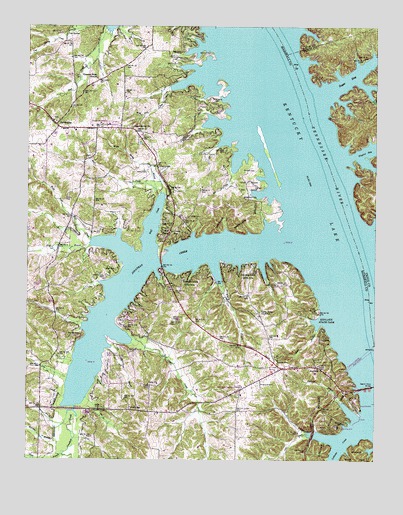
Fairdealing, KY USGS Topographic Map
Click on map above to begin viewing in our Map Viewer.

This topographic map contains these locations and features:
Feature Name Type Latitude Longitude GNIS ID View Map
Aston CemeteryCemeteryN36.8328°W88.2113°486109View Map
AuroraPopulated PlaceN36.7767°W88.1442°486143View Map
Aurora Ross Fire StationBuildingN36.7797°W88.1628°2637183View Map
Aurora SchoolSchoolN36.7792°W88.1598°486144View Map
Barnett CemeteryCemeteryN36.7857°W88.2310°486398View Map
Bee CreekStreamN36.8331°W88.1759°486665View Map
Billie BranchStreamN36.7878°W88.1459°487307View Map
Cap SpringSpringN36.8726°W88.2364°488911View Map
Clear CreekStreamN36.7859°W88.2128°489617View Map
Collie CemeteryCemeteryN36.8255°W88.2365°489842View Map
Cool CreekStreamN36.7576°W88.1498°490018View Map
FairdealingPopulated PlaceN36.8467°W88.2392°507968View Map
Fairdealing - Olive Fire StationBuildingN36.8476°W88.2408°2636374View Map
Fairdealing CemeteryCemeteryN36.8479°W88.2395°2775719View Map
Fairdealing DivisionCivilN36.8373°W88.2185°1936994View Map
Ferguson Spring ChurchChurchN36.7712°W88.1723°492039View Map
Ferguson Springs CemeteryCemeteryN36.7718°W88.1725°2775716View Map
Four Rivers Boy Scout ReservationParkN36.8276°W88.1706°492379View Map
Gregory CemeteryCemeteryN36.8345°W88.2033°493363View Map
Henson CemeteryCemeteryN36.8334°W88.1682°494077View Map
Hiatt CemeteryCemeteryN36.8200°W88.1919°494107View Map
Higgins BayBayN36.8395°W88.1264°494167View Map
Howard CemeteryCemeteryN36.8539°W88.1830°494656View Map
Jonathan CreekStreamN36.8142°W88.1578°495443View Map
Jonathan Creek Cabin AreaParkN36.8006°W88.1698°495444View Map
Jonathan Elementary SchoolSchoolN36.8465°W88.2210°495446View Map
Ledbetter CreekStreamN36.7617°W88.1275°496144View Map
Maple Methodist ChurchChurchN36.8459°W88.2128°497518View Map
Maple Spring BranchStreamN36.8262°W88.2028°497517View Map
Maple Spring CemeteryCemeteryN36.8459°W88.2141°2775718View Map
McClain BranchStreamN36.7628°W88.2353°497782View Map
McLoad CemeteryCemeteryN36.8672°W88.1844°497925View Map
Neale BranchStreamN36.7523°W88.2364°499196View Map
Olive BranchStreamN36.8126°W88.2278°499918View Map
Page CemeteryCemeteryN36.8681°W88.1981°500109View Map
Pirates Cove AirportAirportN36.7794°W88.2216°517337View Map
Pleasant Hope Missionary Baptist ChurchChurchN36.8599°W88.2257°500882View Map
Price CemeteryCemeteryN36.8605°W88.2334°501318View Map
Ruff CreekStreamN36.8112°W88.2059°502459View Map
Ruff Creek Cabin AreaParkN36.8148°W88.1978°502460View Map
Ruff Creek CemeteryCemeteryN36.8374°W88.2294°2775717View Map
Saint Henry Catholic CemeteryCemeteryN36.7779°W88.1559°2775715View Map
Sugar BayBayN36.8606°W88.1364°504629View Map
Terrapin BranchStreamN36.7676°W88.1373°505077View Map
Union Ridge (historical)Populated PlaceN36.7923°W88.1663°2743737View Map
Union Ridge Baptist ChurchChurchN36.7930°W88.1665°505812View Map
Union Ridge CemeteryCemeteryN36.7931°W88.1679°2775714View Map
UnityPopulated PlaceN36.7646°W88.2127°2743738View Map
Unity BranchStreamN36.7823°W88.2206°505830View Map
Unity Cumberland Presbyterian ChurchChurchN36.7722°W88.2062°505832View Map
Unity SchoolSchoolN36.7651°W88.2123°505836View Map
West Fork Bee CreekStreamN36.8567°W88.1981°506421View Map
West Fork Ruff CreekStreamN36.8131°W88.2273°506447View Map
Widow Reynolds Bar Post LightBuildingN36.7503°W88.1334°517042View Map
Wolf BranchStreamN36.8067°W88.1823°506980View Map
WVHM-FM (Benton)TowerN36.8087°W88.2239°517921View Map
Wyatt CemeteryCemeteryN36.8048°W88.2181°507174View Map

Note: Coordinates in the location and feature list above are referenced to NAD83 datum.


Copyright (C) 2008-2024 Ryan Niemi / Sunset Dynamics ... All Rights Reserved