TopoQuest Logo
Do you find TopoQuest useful?
Help keep TopoQuest running and adding new maps/features by donating!
Bitcoin:  19c7KJd3qBynnjoSw5npx9KScwjBe4ifkT
Litecoin:  LXs6TkuXGGXo1vDsWCkWVdjQX94eUKd6ui
Home View Maps Find Maps Find Places Resources & Links


Fenton, Kentucky Topographic Map

USGS Map Title: Fenton, KY
USGS Map MRC: 36088G1
DRG (GeoTIFF) Download: o36088g1.tif


Neighboring USGS Topographic Map Quads:


  Birmingham Point, KY  
36088H2
 

  Mont, KY  
36088H1
 

  Lamasco, KY  
36087H8
 

  Fairdealing, KY  
36088G2
 

  Fenton, KY  
36088G1
 

  Canton, KY  
36087G8
 

  Hico, KY  
36088F2
 

  Rushing Bay, TN  
36088F1
 

  Linton, KY  
36087F8


Map MRC Location:

N37°
W89°
N37°
W88°
H8 H7 H6 H5 H4 H3 H2 H1
G8 G7 G6 G5 G4 G3 G2 G1
F8 F7 F6 F5 F4 F3 F2 F1
E8 E7 E6 E5 E4 E3 E2 E1
D8 D7 D6 D5 D4 D3 D2 D1
C8 C7 C6 C5 C4 C3 C2 C1
B8 B7 B6 B5 B4 B3 B2 B1
A8 A7 A6 A5 A4 A3 A2 A1
N36°
W89°
N36°
W88°

Fenton, KY USGS 1:24K Topographic Map Preview:
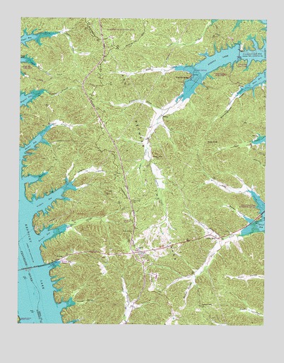
Fenton, KY USGS Topographic Map
Click on map above to begin viewing in our Map Viewer.

This topographic map contains these locations and features:
Feature Name Type Latitude Longitude GNIS ID View Map
Bald KnobSummitN36.8248°W88.0297°486263View Map
Barnett BayBayN36.7862°W88.1123°486390View Map
Barnett CreekStreamN36.7867°W88.1081°486404View Map
Boardinghouse HollowValleyN36.8478°W88.0081°487583View Map
Crooked CreekStreamN36.8517°W88.0325°490374View Map
Crooked Creek BayBayN36.8606°W88.0042°490383View Map
Eggner Ferry BridgeBridgeN36.7726°W88.1203°491586View Map
Elbow CreekStreamN36.7901°W88.0045°491610View Map
EnergyLocaleN36.8351°W88.0520°491776View Map
Energy LakeLakeN36.8583°W88.0245°491777View Map
FentonPopulated PlaceN36.7770°W88.1028°507987View Map
Ferguson SpringPopulated PlaceN36.8512°W88.0392°507991View Map
Franklin CreekStreamN36.8389°W88.0486°492452View Map
Golden PondPopulated PlaceN36.7856°W88.0242°508108View Map
Golden PondLakeN36.7793°W88.0635°492943View Map
Gordon HillSummitN36.7584°W88.0322°493029View Map
Gordon HollowValleyN36.7687°W88.0359°493030View Map
Grace CreekStreamN36.8220°W88.0600°493069View Map
Higgins BranchStreamN36.8448°W88.1150°494168View Map
Jenny Ridge CemeteryCemeteryN36.8000°W88.0670°495216View Map
Kentucky Woodlands National Wildlife RefugeParkN36.7501°W88.0834°507319View Map
Land Between the Lakes DivisionCivilN36.7870°W88.0423°1937295View Map
Little CreekStreamN36.8548°W88.0356°496686View Map
Long CreekStreamN36.7981°W88.0014°497092View Map
Matheny CemeteryCemeteryN36.7809°W88.0645°497676View Map
North Fork Sugar CreekStreamN36.8670°W88.1175°499568View Map
Oakley HollowValleyN36.7924°W88.0068°499750View Map
Pleasant Valley CemeteryCemeteryN36.8175°W88.0545°500920View Map
Rhodes BayBayN36.8228°W88.1195°501756View Map
Rhodes CreekStreamN36.8267°W88.1153°501758View Map
Savells BranchStreamN36.8092°W88.1159°503007View Map
Scout TrailTrailN36.8209°W88.1078°503119View Map
Shaw BranchStreamN36.8476°W88.0081°503272View Map
South Fork Sugar CreekStreamN36.8578°W88.1231°503948View Map
Turner HollowValleyN36.7584°W88.0973°505663View Map
Vickers BayBayN36.8001°W88.1111°506038View Map
Vickers CreekStreamN36.8037°W88.1042°506039View Map

Note: Coordinates in the location and feature list above are referenced to NAD83 datum.


Copyright (C) 2008-2024 Ryan Niemi / Sunset Dynamics ... All Rights Reserved