TopoQuest Logo
Do you find TopoQuest useful?
Help keep TopoQuest running and adding new maps/features by donating!
Bitcoin:  19c7KJd3qBynnjoSw5npx9KScwjBe4ifkT
Litecoin:  LXs6TkuXGGXo1vDsWCkWVdjQX94eUKd6ui
Home View Maps Find Maps Find Places Resources & Links


Hardin, Kentucky Topographic Map

USGS Map Title: Hardin, KY
USGS Map MRC: 36088G3
DRG (GeoTIFF) Download: o36088g3.tif


Neighboring USGS Topographic Map Quads:


  Elva, KY  
36088H4
 

  Briensburg, KY  
36088H3
 

  Birmingham Point, KY  
36088H2
 

  Oak Level, KY  
36088G4
 

  Hardin, KY  
36088G3
 

  Fairdealing, KY  
36088G2
 

  Kirksey, KY  
36088F4
 

  Dexter, KY  
36088F3
 

  Hico, KY  
36088F2


Map MRC Location:

N37°
W89°
N37°
W88°
H8 H7 H6 H5 H4 H3 H2 H1
G8 G7 G6 G5 G4 G3 G2 G1
F8 F7 F6 F5 F4 F3 F2 F1
E8 E7 E6 E5 E4 E3 E2 E1
D8 D7 D6 D5 D4 D3 D2 D1
C8 C7 C6 C5 C4 C3 C2 C1
B8 B7 B6 B5 B4 B3 B2 B1
A8 A7 A6 A5 A4 A3 A2 A1
N36°
W89°
N36°
W88°

Hardin, KY USGS 1:24K Topographic Map Preview:
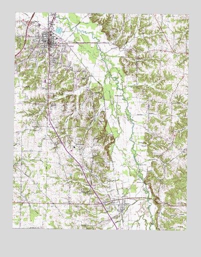
Hardin, KY USGS Topographic Map
Click on map above to begin viewing in our Map Viewer.

This topographic map contains these locations and features:
Feature Name Type Latitude Longitude GNIS ID View Map
Banks Family CemeteryCemeteryN36.8358°W88.3647°2775724View Map
Beaverdam SloughStreamN36.8414°W88.3081°486634View Map
BentonPopulated PlaceN36.8573°W88.3503°486888View Map
Benton CemeteryCemeteryN36.8544°W88.3574°2775723View Map
Benton Fire StationBuildingN36.8554°W88.3581°2636272View Map
Benton Police DepartmentBuildingN36.8582°W88.3505°2767549View Map
Burnham BranchStreamN36.8670°W88.3314°488448View Map
Chestnut HillSummitN36.8003°W88.2806°489448View Map
Church Grove ChurchChurchN36.8306°W88.3509°489511View Map
City of BentonCivilN36.8524°W88.3589°2403856View Map
City of HardinCivilN36.7651°W88.3023°2403798View Map
Cope CemeteryCemeteryN36.8126°W88.3100°490070View Map
Cope CreekStreamN36.8306°W88.3085°490071View Map
Darnell CemeteryCemeteryN36.7995°W88.3432°2775708View Map
DogtownPopulated PlaceN36.8378°W88.3234°490987View Map
Dowdy CemeteryCemeteryN36.8068°W88.3611°2775709View Map
Dry BranchStreamN36.8573°W88.3300°491137View Map
Dunn CemeteryCemeteryN36.8657°W88.2846°491321View Map
Elizabeth CreekStreamN36.8517°W88.3114°491638View Map
Ellison CreekStreamN36.7739°W88.2911°491722View Map
FlatwoodsAreaN36.8284°W88.3713°2743713View Map
Ford CemeteryCemeteryN36.8589°W88.3725°492303View Map
Gain BranchStreamN36.8237°W88.3500°492649View Map
GladePopulated PlaceN36.8189°W88.3117°508095View Map
Haltom CemeteryCemeteryN36.8440°W88.3494°2775721View Map
Hamlet (historical)Populated PlaceN36.8574°W88.3039°2743716View Map
Hamlet Baptist ChurchChurchN36.8534°W88.2847°493628View Map
Hamlet CemeteryCemeteryN36.8533°W88.2842°2775720View Map
HardinPopulated PlaceN36.7648°W88.2953°493717View Map
Hardin - South Marshal Fire StationBuildingN36.7618°W88.2965°2636405View Map
Haymes CemeteryCemeteryN36.7959°W88.3184°493914View Map
Hiett CemeteryCemeteryN36.8390°W88.3210°2775713View Map
Horn CemeteryCemeteryN36.8034°W88.2615°494565View Map
Johns RiverStreamN36.8651°W88.3348°495356View Map
JoppaPopulated PlaceN36.7655°W88.2646°2743719View Map
Liberty (historical)Populated PlaceN36.7921°W88.3177°2743725View Map
Lovette BranchStreamN36.7853°W88.2845°497225View Map
Marshall County HospitalHospitalN36.8672°W88.3699°2660349View Map
Marshall County Hospital HeliportAirportN36.8626°W88.3528°517338View Map
Marshall County Sheriff's OfficeBuildingN36.8664°W88.3561°2767514View Map
Martins CreekStreamN36.7795°W88.2848°497627View Map
Monkey Den (historical)Populated PlaceN36.8060°W88.3144°2743729View Map
Myers CreekStreamN36.7945°W88.2964°499149View Map
Nanny CreekStreamN36.8309°W88.2978°499164View Map
New Zion Baptist ChurchChurchN36.7867°W88.3742°499411View Map
Nimmo HillSummitN36.7778°W88.2803°499484View Map
Norwood BranchStreamN36.7942°W88.2873°499620View Map
OlivePopulated PlaceN36.8009°W88.2611°499916View Map
Olive CemeteryCemeteryN36.7998°W88.2609°2775711View Map
Pace CemeteryCemeteryN36.7659°W88.3098°500092View Map
Peggy Ann SpringSpringN36.7715°W88.3211°500358View Map
Sinkhole HillSummitN36.8212°W88.3498°503556View Map
Sixacre BranchStreamN36.8170°W88.2917°503584View Map
South Fork Watch CreekStreamN36.8311°W88.3272°503950View Map
South MarshallPopulated PlaceN36.7981°W88.3300°509097View Map
Spencer Starks CemeteryCemeteryN36.7783°W88.3063°2775707View Map
Starks CemeteryCemeteryN36.7815°W88.3107°2775706View Map
Straw BranchStreamN36.8742°W88.3489°504576View Map
Sugartree FordLocaleN36.7878°W88.2859°504709View Map
Taylor PondLakeN36.8739°W88.2604°505035View Map
Thompson CemeteryCemeteryN36.8521°W88.3528°2775722View Map
Thompson CemeteryCemeteryN36.8265°W88.3478°505190View Map
Town CreekStreamN36.8670°W88.3361°505390View Map
Tubbs BranchStreamN36.8587°W88.3145°505529View Map
Union Hill (historical)Populated PlaceN36.7713°W88.3190°2743736View Map
Union Hill CemeteryCemeteryN36.7734°W88.3256°505802View Map
Union Hill Church of ChristChurchN36.7705°W88.3192°505804View Map
Wades CreekStreamN36.7684°W88.2784°506092View Map
Wadesboro CemeteryCemeteryN36.7521°W88.3218°506094View Map
Walnut GrovePopulated PlaceN36.8287°W88.3186°506168View Map
Walnut Grove Church of Christ CemeteryCemeteryN36.8273°W88.3180°2775712View Map
Washburn FordLocaleN36.8276°W88.2973°506245View Map
Watch CreekStreamN36.8481°W88.3167°506254View Map
WCBL-AM (Benton)TowerN36.8584°W88.3370°517568View Map
WCBL-FM (Benton)TowerN36.8584°W88.3370°517680View Map
Woods BranchStreamN36.8003°W88.2884°507113View Map
Woods CemeteryCemeteryN36.8090°W88.3577°2775710View Map
Yancy Darnell (historical)Populated PlaceN36.7875°W88.3411°2743741View Map
York CreekStreamN36.8509°W88.3109°507234View Map

Note: Coordinates in the location and feature list above are referenced to NAD83 datum.


Copyright (C) 2008-2025 Ryan Niemi / Sunset Dynamics ... All Rights Reserved