TopoQuest Logo
Do you find TopoQuest useful?
Help keep TopoQuest running and adding new maps/features by donating!
Bitcoin:  19c7KJd3qBynnjoSw5npx9KScwjBe4ifkT
Litecoin:  LXs6TkuXGGXo1vDsWCkWVdjQX94eUKd6ui
Home View Maps Find Maps Find Places Resources & Links


Rushing Bay, Tennessee Topographic Map

USGS Map Title: Rushing Bay, TN
USGS Map MRC: 36088F1
DRG (GeoTIFF) Download: o36088f1.tif


Neighboring USGS Topographic Map Quads:


  Fairdealing, KY  
36088G2
 

  Fenton, KY  
36088G1
 

  Canton, KY  
36087G8
 

  Hico, KY  
36088F2
 

  Rushing Bay, TN  
36088F1
 

  Linton, KY  
36087F8
 

  New Concord, KY  
36088E2
 

  Hamlin, KY  
36088E1
 

  Tharpe, TN  
36087E8


Map MRC Location:

N37°
W89°
N37°
W88°
H8 H7 H6 H5 H4 H3 H2 H1
G8 G7 G6 G5 G4 G3 G2 G1
F8 F7 F6 F5 F4 F3 F2 F1
E8 E7 E6 E5 E4 E3 E2 E1
D8 D7 D6 D5 D4 D3 D2 D1
C8 C7 C6 C5 C4 C3 C2 C1
B8 B7 B6 B5 B4 B3 B2 B1
A8 A7 A6 A5 A4 A3 A2 A1
N36°
W89°
N36°
W88°

Rushing Bay, TN USGS 1:24K Topographic Map Preview:
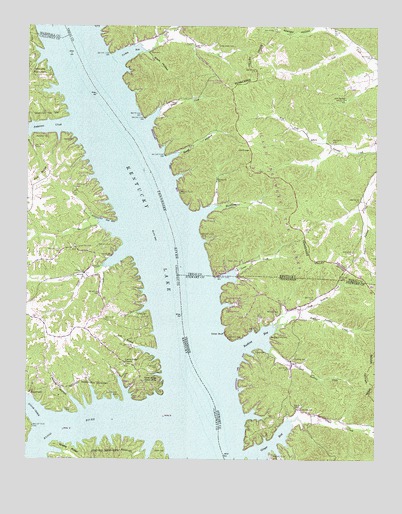
Rushing Bay, TN USGS Topographic Map
Click on map above to begin viewing in our Map Viewer.

This topographic map contains these locations and features:
Feature Name Type Latitude Longitude GNIS ID View Map
Anderson CreekStreamN36.7214°W88.1100°485938View Map
Arlt SpringSpringN36.7297°W88.0112°486032View Map
Banner CemeteryCemeteryN36.6523°W88.0787°486319View Map
Blockhouse CreekStreamN36.6951°W88.0645°487487View Map
Blood RiverStreamN36.6398°W88.0753°487489View Map
Blood River BarBarN36.6306°W88.0556°1642925View Map
BoatwrightPopulated PlaceN36.6442°W88.1236°487589View Map
Boatyard CreekStreamN36.6395°W88.0553°1308787View Map
Boatyard Landing (historical)LocaleN36.6409°W88.0556°1308788View Map
Cedar BluffCliffN36.6612°W88.0539°1279995View Map
Cedar SpringsSpringN36.6601°W88.0528°1308810View Map
Center Ridge (historical)Populated PlaceN36.6526°W88.0877°2743614View Map
Center Ridge Cabin AreaLocaleN36.6476°W88.0775°489271View Map
Center Ridge CemeteryCemeteryN36.6523°W88.0900°2775701View Map
Center Ridge ChurchChurchN36.6523°W88.0892°489272View Map
Clyde Landing (historical)LocaleN36.6645°W88.0667°1308818View Map
Colson CreekStreamN36.7226°W88.0817°489882View Map
Colson Hollow OverlookLocaleN36.7345°W88.0547°489883View Map
Dilday CemeteryCemeteryN36.6564°W88.0429°1282469View Map
Dilday Landing (historical)LocaleN36.6764°W88.0681°1308826View Map
Downs CemeteryCemeteryN36.6820°W88.0489°491078View Map
Evans CemeteryCemeteryN36.6392°W88.1090°491830View Map
Futrell Store (historical)LocaleN36.6381°W88.0214°1308847View Map
Ginger BayBayN36.6292°W88.0375°1285453View Map
Ginger CreekStreamN36.6362°W88.0303°1285454View Map
Ginger Ridge Back Country CampLocaleN36.6334°W88.0425°1308851View Map
Haynes CemeteryCemeteryN36.7173°W88.1081°493917View Map
Hendon CemeteryCemeteryN36.6392°W88.0256°1287392View Map
Hickory Landing (historical)LocaleN36.6689°W88.0670°1642941View Map
Hicks HollowValleyN36.6776°W88.0492°1308869View Map
Hooper CemeteryCemeteryN36.6666°W88.0816°494506View Map
Hooper HollowValleyN36.6428°W88.1089°494508View Map
Jones CreekStreamN36.6753°W88.0561°495488View Map
Jones Creek Day Use AreaLocaleN36.6784°W88.0567°495496View Map
Kirk RidgeRidgeN36.7067°W88.1203°495797View Map
Land Between the Lakes National ForestForestN36.7489°W88.0359°495951View Map
Lick BranchStreamN36.6556°W88.0781°496396View Map
Lone Oak (historical)Populated PlaceN36.6853°W88.1065°2743632View Map
Lone Oak CemeteryCemeteryN36.6862°W88.1067°497000View Map
Lone Oak Landing (historical)LocaleN36.6531°W88.0639°1308892View Map
Mays CemeteryCemeteryN36.7425°W88.0806°497742View Map
Mays HollowValleyN36.7427°W88.0823°497749View Map
McDaniel CemeteryCemeteryN36.7176°W88.1222°497833View Map
Middle Rushing CreekStreamN36.6631°W88.0359°1293696View Map
North Fork Turkey CreekStreamN36.7456°W88.0770°499571View Map
North Rushing CreekStreamN36.6639°W88.0367°1295946View Map
Parker - Oak Hill CemeteryCemeteryN36.6274°W88.0789°500188View Map
Redd HollowValleyN36.7127°W88.0724°501679View Map
Rushing (historical)Populated PlaceN36.6617°W88.0361°1308958View Map
Rushing BayBayN36.6598°W88.0425°1300273View Map
Rushing CemeteryCemeteryN36.6541°W88.0290°1300281View Map
Rushing Creek (historical)StreamN36.6756°W88.0678°1311740View Map
Rushing Creek CampgroundLocaleN36.6698°W88.0503°1300285View Map
Rushing Creek CemeteryCemeteryN36.6603°W88.0372°1300286View Map
Sheep RidgeRidgeN36.6281°W88.1092°503308View Map
Snipe CreekStreamN36.6851°W88.0892°503853View Map
South Rushing CreekStreamN36.6562°W88.0384°1270912View Map
Sugar CreekStreamN36.6356°W88.1181°504651View Map
Turkey BayBayN36.7417°W88.0903°505579View Map
Turkey CreekStreamN36.7428°W88.0823°505586View Map
Turkey Creek CemeteryCemeteryN36.7439°W88.0564°505600View Map
Vincents Landing (historical)LocaleN36.6328°W88.0534°1642968View Map
Vinson CemeteryCemeteryN36.6370°W88.0331°1309005View Map
Vinson Pond (historical)LakeN36.6473°W88.0534°1309006View Map
Wienger HollowValleyN36.7495°W88.0232°506714View Map
Williams CemeteryCemeteryN36.6673°W88.0347°1274688View Map

Note: Coordinates in the location and feature list above are referenced to NAD83 datum.


Copyright (C) 2008-2024 Ryan Niemi / Sunset Dynamics ... All Rights Reserved