TopoQuest Logo
Do you find TopoQuest useful?
Help keep TopoQuest running and adding new maps/features by donating!
Bitcoin:  19c7KJd3qBynnjoSw5npx9KScwjBe4ifkT
Litecoin:  LXs6TkuXGGXo1vDsWCkWVdjQX94eUKd6ui
Home View Maps Find Maps Find Places Resources & Links


Fairview, Utah Topographic Map

USGS Map Title: Fairview, UT
USGS Map MRC: 39111F4
DRG (GeoTIFF) Download: o39111f4.tif


Neighboring USGS Topographic Map Quads:


  Spencer Canyon, UT  
39111G5
 

  Indianola, UT  
39111G4
 

  C Canyon, UT  
39111G3
 

  Big Hollow, UT  
39111F5
 

  Fairview, UT  
39111F4
 

  Fairview Lakes, UT  
39111F3
 

  Moroni, UT  
39111E5
 

  Mount Pleasant, UT  
39111E4
 

  Huntington Reservoir, UT  
39111E3


Map MRC Location:

N40°
W112°
N40°
W111°
H8 H7 H6 H5 H4 H3 H2 H1
G8 G7 G6 G5 G4 G3 G2 G1
F8 F7 F6 F5 F4 F3 F2 F1
E8 E7 E6 E5 E4 E3 E2 E1
D8 D7 D6 D5 D4 D3 D2 D1
C8 C7 C6 C5 C4 C3 C2 C1
B8 B7 B6 B5 B4 B3 B2 B1
A8 A7 A6 A5 A4 A3 A2 A1
N39°
W112°
N39°
W111°

Fairview, UT USGS 1:24K Topographic Map Preview:
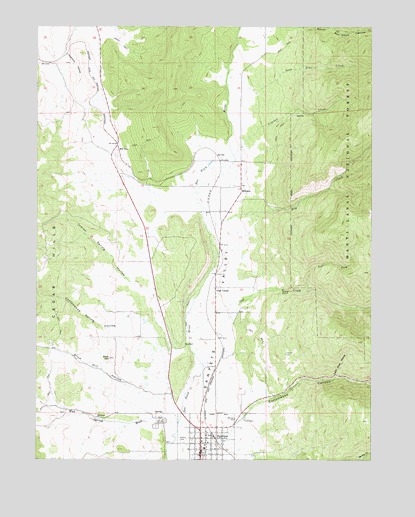
Fairview, UT USGS Topographic Map
Click on map above to begin viewing in our Map Viewer.

This topographic map contains these locations and features:
Feature Name Type Latitude Longitude GNIS ID View Map
Cedar HillsSummitN39.6505°W111.4938°1439570View Map
City of FairviewCivilN39.6303°W111.4368°2410479View Map
Cottonwood Spring HollowValleyN39.6652°W111.4605°1440043View Map
Crooked CreekStreamN39.7125°W111.4277°1440164View Map
Dry CreekStreamN39.6902°W111.4369°1440600View Map
FairviewPopulated PlaceN39.6264°W111.4396°1440983View Map
Fairview Ambulance AssociationBuildingN39.6307°W111.4396°2665414View Map
Fairview CanyonValleyN39.6375°W111.4230°1449910View Map
Fairview Elementary SchoolSchoolN39.6315°W111.4259°1448388View Map
Fairview Lower CemeteryCemeteryN39.6363°W111.4527°1440984View Map
Fairview Police DepartmentBuildingN39.6307°W111.4396°2730458View Map
Fairview Post OfficePost OfficeN39.6283°W111.4404°1455267View Map
Fairview Upper CemeteryCemeteryN39.6350°W111.4559°2769399View Map
Fairview Volunteer Fire DepartmentBuildingN39.6307°W111.4396°2627325View Map
Hill TopPopulated PlaceN39.7147°W111.4702°1441772View Map
Hilltop Wildlife Management AreaParkN39.6833°W111.4474°1448478View Map
Indian Spring HollowValleyN39.6680°W111.4555°1442030View Map
Josephine HollowValleyN39.7419°W111.4899°1442228View Map
Left Fork Oak CreekStreamN39.6736°W111.3999°1442517View Map
Lone Pine CreekStreamN39.7302°W111.4196°1442874View Map
Lone Rock RavineValleyN39.6486°W111.3899°1442882View Map
Maple ForkStreamN39.6469°W111.3782°1443164View Map
MilburnPopulated PlaceN39.7041°W111.4249°1443385View Map
Mud Spring WashValleyN39.6375°W111.4527°1848356View Map
North Fork Mud Spring WashValleyN39.6394°W111.4888°1448744View Map
Oak CreekPopulated PlaceN39.6747°W111.4344°1444014View Map
Oak CreekStreamN39.6602°W111.4441°1444017View Map
Slick HillSummitN39.6544°W111.4738°1445674View Map
Slick Hill HollowValleyN39.6430°W111.4524°1455896View Map
The Church of Jesus Christ of Latter Day SaintsChurchN39.6261°W111.4396°1449445View Map
The Church of Jesus Christ of Latter Day SaintsChurchN39.6300°W111.4366°1449446View Map

Note: Coordinates in the location and feature list above are referenced to NAD83 datum.


Copyright (C) 2008-2025 Ryan Niemi / Sunset Dynamics ... All Rights Reserved