TopoQuest Logo
Do you find TopoQuest useful?
Help keep TopoQuest running and adding new maps/features by donating!
Bitcoin:  19c7KJd3qBynnjoSw5npx9KScwjBe4ifkT
Litecoin:  LXs6TkuXGGXo1vDsWCkWVdjQX94eUKd6ui
Home View Maps Find Maps Find Places Resources & Links


Faith, Arkansas Topographic Map

USGS Map Title: Faith, AR
USGS Map MRC: 34092A1
DRG (GeoTIFF) Download: o34092a1.tif


Neighboring USGS Topographic Map Quads:


  Pine Bluff NW, AR  
34092B2
 

  Pine Bluff, AR  
34092B1
 

  Ladd, AR  
34091B8
 

  Kedron, AR  
34092A2
 

  Faith, AR  
34092A1
 

  Pinebergen, AR  
34091A8
 

  Rison, AR  
33092H2
 

  Calmer, AR  
33092H1
 

  Glendale, AR  
33091H8


Map MRC Location:

N35°
W93°
N35°
W92°
H8 H7 H6 H5 H4 H3 H2 H1
G8 G7 G6 G5 G4 G3 G2 G1
F8 F7 F6 F5 F4 F3 F2 F1
E8 E7 E6 E5 E4 E3 E2 E1
D8 D7 D6 D5 D4 D3 D2 D1
C8 C7 C6 C5 C4 C3 C2 C1
B8 B7 B6 B5 B4 B3 B2 B1
A8 A7 A6 A5 A4 A3 A2 A1
N34°
W93°
N34°
W92°

Faith, AR USGS 1:24K Topographic Map Preview:
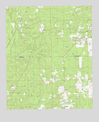
Faith, AR USGS Topographic Map
Click on map above to begin viewing in our Map Viewer.

This topographic map contains these locations and features:
Feature Name Type Latitude Longitude GNIS ID View Map
Blackwell CemeteryCemeteryN34.0962°W92.0721°46697View Map
Brown CemeteryCemeteryN34.0954°W92.1051°46992View Map
Cane CreekStreamN34.0698°W92.1179°47374View Map
Curl CemeteryCemeteryN34.1104°W92.1037°48267View Map
Dialton (historical)Populated PlaceN34.0423°W92.1024°60985View Map
Eudora ChurchChurchN34.1148°W92.0279°48922View Map
FaithPopulated PlaceN34.1037°W92.1035°76905View Map
Harmony ChurchChurchN34.0862°W92.0104°49869View Map
Highway 15 Volunteer Fire DepartmentBuildingN34.0866°W92.0058°2116568View Map
Kedron ChurchChurchN34.0201°W92.1099°50775View Map
Lehigh (historical)Populated PlaceN34.0023°W92.0918°60992View Map
Little Brushy CreekStreamN34.0129°W92.0774°51207View Map
Mount Gilead ChurchChurchN34.0098°W92.0410°52289View Map
Mount ZionPopulated PlaceN34.0268°W92.1121°52438View Map
Mount Zion ChurchChurchN34.0282°W92.1149°52462View Map
Mount Zion ChurchChurchN34.0857°W92.0821°52463View Map
Pleasant Ridge CemeteryCemeteryN34.0359°W92.0501°1939775View Map
Pleasant Ridge ChurchChurchN34.0365°W92.0499°53594View Map
RandallPopulated PlaceN34.0234°W92.0413°58459View Map
Rose Lawn Memorial GardenCemeteryN34.0826°W92.0226°54207View Map
Studdard LakeReservoirN34.0323°W92.0846°80290View Map
Studdard Lake DamDamN34.0301°W92.0851°80289View Map
Township of BowmanCivilN34.0194°W92.1103°63733View Map
Township of WhitevilleCivilN34.1069°W92.0089°66750View Map
Township of WhitevilleCivilN34.0141°W92.0438°63748View Map
Wesley ChapelChurchN34.0032°W92.0410°56153View Map
Wesley Chapel CemeteryCemeteryN34.0029°W92.0410°1901195View Map

Note: Coordinates in the location and feature list above are referenced to NAD83 datum.


Copyright (C) 2008-2025 Ryan Niemi / Sunset Dynamics ... All Rights Reserved