TopoQuest Logo
Do you find TopoQuest useful?
Help keep TopoQuest running and adding new maps/features by donating!
Bitcoin:  19c7KJd3qBynnjoSw5npx9KScwjBe4ifkT
Litecoin:  LXs6TkuXGGXo1vDsWCkWVdjQX94eUKd6ui
Home View Maps Find Maps Find Places Resources & Links


Fall River, Wisconsin Topographic Map

USGS Map Title: Fall River, WI
USGS Map MRC: 43089D1
DRG (GeoTIFF) Download: o43089d1.tif


Neighboring USGS Topographic Map Quads:


  Sand Spring Creek, WI  
43089E2
 

  Randolph, WI  
43089E1
 

  Fox Lake, WI  
43088E8
 

  Rio, WI  
43089D2
 

  Fall River, WI  
43089D1
 

  Lost Lake, WI  
43088D8
 

  North Bristol, WI  
43089C2
 

  Columbus, WI  
43089C1
 

  Astico, WI  
43088C8


Map MRC Location:

N44°
W90°
N44°
W89°
H8 H7 H6 H5 H4 H3 H2 H1
G8 G7 G6 G5 G4 G3 G2 G1
F8 F7 F6 F5 F4 F3 F2 F1
E8 E7 E6 E5 E4 E3 E2 E1
D8 D7 D6 D5 D4 D3 D2 D1
C8 C7 C6 C5 C4 C3 C2 C1
B8 B7 B6 B5 B4 B3 B2 B1
A8 A7 A6 A5 A4 A3 A2 A1
N43°
W90°
N43°
W89°

Fall River, WI USGS 1:24K Topographic Map Preview:
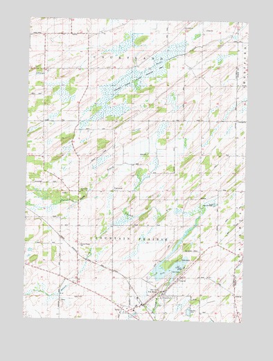
Fall River, WI USGS Topographic Map
Click on map above to begin viewing in our Map Viewer.

This topographic map contains these locations and features:
Feature Name Type Latitude Longitude GNIS ID View Map
Bennett School (historical)SchoolN43.4133°W89.1007°1561567View Map
Brace School (historical)SchoolN43.4253°W89.0321°1562119View Map
Courtland Bennett School (historical)SchoolN43.4969°W89.0376°1563458View Map
Courtland ChurchChurchN43.4969°W89.0362°1842945View Map
Courtland Methodist Episcopal CemeteryCemeteryN43.4964°W89.0359°1955169View Map
England School (historical)SchoolN43.4578°W89.0407°1564654View Map
EnglewoodPopulated PlaceN43.4286°W89.0751°1842955View Map
Englewood School (historical)SchoolN43.4286°W89.0762°1564661View Map
Fall RiverPopulated PlaceN43.3844°W89.0451°1564844View Map
Fall River 2WP73 DamDamN43.3917°W89.0418°1791886View Map
Fall River CemeteryCemeteryN43.3933°W89.0351°1564845View Map
Fall River Elementary SchoolSchoolN43.3861°W89.0456°2716827View Map
Fall River High SchoolSchoolN43.3860°W89.0455°1842956View Map
Fall River Police DepartmentBuildingN43.3808°W89.0583°2759980View Map
Fall River Volunteer Fire DepartmentBuildingN43.3785°W89.0439°2697757View Map
Fountain Prairie AirportAirportN43.3810°W89.0091°2444187View Map
Fountain Prairie CemeteryCemeteryN43.4064°W89.0943°1565180View Map
Lazy LakeReservoirN43.3949°W89.0456°1567902View Map
Lazy Lake 61ReservoirN43.3961°W89.0396°1791887View Map
McKinley School (historical)SchoolN43.4575°W89.1168°1569253View Map
Paradise Marsh State Wildlife AreaParkN43.4750°W89.0648°1842995View Map
Rust School (historical)SchoolN43.4944°W89.0954°1572757View Map
Saint Stephen CemeteryCemeteryN43.4286°W89.0946°1843032View Map
Saint Stephen Church (historical)ChurchN43.4289°W89.0957°1573572View Map
Town of Fountain PrairieCivilN43.4158°W89.0665°1583224View Map
Village of Fall RiverCivilN43.3856°W89.0456°1583189View Map

Note: Coordinates in the location and feature list above are referenced to NAD83 datum.


Copyright (C) 2008-2024 Ryan Niemi / Sunset Dynamics ... All Rights Reserved