TopoQuest Logo
Do you find TopoQuest useful?
Help keep TopoQuest running and adding new maps/features by donating!
Bitcoin:  19c7KJd3qBynnjoSw5npx9KScwjBe4ifkT
Litecoin:  LXs6TkuXGGXo1vDsWCkWVdjQX94eUKd6ui
Home View Maps Find Maps Find Places Resources & Links


Fox Lake, Wisconsin Topographic Map

USGS Map Title: Fox Lake, WI
USGS Map MRC: 43088E8
DRG (GeoTIFF) Download: o43088e8.tif


Neighboring USGS Topographic Map Quads:


  Manchester, WI  
43089F1
 

  Markesan, WI  
43088F8
 

  Brandon, WI  
43088F7
 

  Randolph, WI  
43089E1
 

  Fox Lake, WI  
43088E8
 

  Buckhorn Corner, WI  
43088E7
 

  Fall River, WI  
43089D1
 

  Lost Lake, WI  
43088D8
 

  Beaver Dam, WI  
43088D7


Map MRC Location:

N44°
W89°
N44°
W88°
H8 H7 H6 H5 H4 H3 H2 H1
G8 G7 G6 G5 G4 G3 G2 G1
F8 F7 F6 F5 F4 F3 F2 F1
E8 E7 E6 E5 E4 E3 E2 E1
D8 D7 D6 D5 D4 D3 D2 D1
C8 C7 C6 C5 C4 C3 C2 C1
B8 B7 B6 B5 B4 B3 B2 B1
A8 A7 A6 A5 A4 A3 A2 A1
N43°
W89°
N43°
W88°

Fox Lake, WI USGS 1:24K Topographic Map Preview:
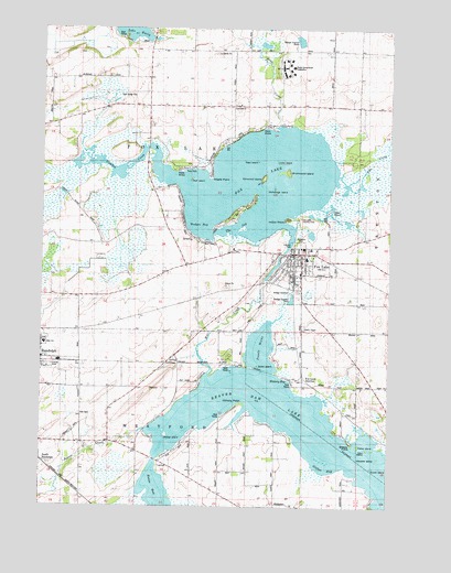
Fox Lake, WI USGS Topographic Map
Click on map above to begin viewing in our Map Viewer.

This topographic map contains these locations and features:
Feature Name Type Latitude Longitude GNIS ID View Map
Alto CreekStreamN43.5861°W88.8940°1560806View Map
Beaver CreekStreamN43.5197°W88.9623°1561442View Map
Beaver Dam LakeLakeN43.5206°W88.9024°1561480View Map
Beaver Dam Lake Seaplane BaseAirportN43.5150°W88.9526°1582170View Map
Bedker IslandIslandN43.5189°W88.9548°1850635View Map
Breezy PointCapeN43.5161°W88.8882°1850641View Map
Brushwood IslandIslandN43.5875°W88.9121°1562310View Map
City of Fox LakeCivilN43.5618°W88.9131°1583225View Map
Clausen ParkParkN43.5689°W88.9096°1850653View Map
Dead IslandIslandN43.5905°W88.9223°1563770View Map
Deboer FarmsLocaleN43.5486°W88.9644°2705128View Map
Delbern AcresPopulated PlaceN43.6003°W88.9140°1850663View Map
Devil IslandIslandN43.5853°W88.9465°1563924View Map
Drew CreekStreamN43.5997°W88.9157°1564106View Map
Elmwood IslandIslandN43.5861°W88.9209°1564585View Map
Firemans ParkParkN43.5655°W88.9026°1850703View Map
First Congregational United Church of ChristChurchN43.5644°W88.9093°1850709View Map
First Presbyterian ChurchChurchN43.5647°W88.9115°1850712View Map
Fisher IslandIslandN43.5161°W88.8859°1850717View Map
Fisher SchoolSchoolN43.5630°W88.9479°1565020View Map
Fox LakePopulated PlaceN43.5655°W88.9065°1565222View Map
Fox LakeReservoirN43.5592°W88.9198°1565223View Map
Fox Lake 52ReservoirN43.5639°W88.9145°1792143View Map
Fox Lake Community CenterBuildingN43.5655°W88.9026°1850719View Map
Fox Lake Correctional InstitutionBuildingN43.6166°W88.9146°2756154View Map
Fox Lake Correctional Institution SchoolSchoolN43.6149°W88.9144°2716542View Map
Fox Lake Country ClubLocaleN43.5755°W88.9071°1850720View Map
Fox Lake DamDamN43.5592°W88.9198°1792142View Map
Fox Lake Depot MuseumBuildingN43.5608°W88.9093°1850721View Map
Fox Lake Elementary SchoolSchoolN43.5647°W88.9045°1850722View Map
Fox Lake JunctionPopulated PlaceN43.5311°W88.9026°1577605View Map
Fox Lake Police DepartmentBuildingN43.5655°W88.9024°2759724View Map
Fox Lake Post OfficePost OfficeN43.5658°W88.9100°2723982View Map
Fox Lake Public LibraryBuildingN43.5661°W88.9073°1850723View Map
Fox Lake Sewage Treatment PlantLocaleN43.5742°W88.9644°2723969View Map
Fox Lake Town Police DepartmentBuildingN43.6042°W88.9285°2759955View Map
Fox Lake Volunteer Fire DepartmentBuildingN43.5656°W88.9028°2697499View Map
Fox Ram FarmLocaleN43.5489°W88.9722°2705129View Map
Gilfins BayBayN43.5100°W88.8984°1850726View Map
Goose IslandIslandN43.5103°W88.8807°1850728View Map
Hall CemeteryCemeteryN43.5239°W88.9857°1565984View Map
Hickory BayBayN43.5328°W88.9112°1850731View Map
Hickory PointCapeN43.5269°W88.9279°1566360View Map
Indian PointCapeN43.5750°W88.9126°1566926View Map
Island SchoolSchoolN43.5039°W88.9359°1567043View Map
Jeanette Adams Municipal Swimming PoolParkN43.5653°W88.9032°1850746View Map
Lake Emily CemeteryCemeteryN43.6080°W88.9676°1567733View Map
Lake View SchoolSchoolN43.6050°W88.8979°1567764View Map
Lone IslandIslandN43.5903°W88.9165°1568506View Map
Lyndon DalePopulated PlaceN43.5772°W88.9307°1568843View Map
Maple PointCapeN43.5864°W88.9398°1568992View Map
McFetridge IslandIslandN43.5825°W88.9198°1569215View Map
Meagher FarmsLocaleN43.5328°W88.9642°2705130View Map
Moon IslandIslandN43.5369°W88.9221°1850786View Map
New IslandIslandN43.5153°W88.8826°1850791View Map
Pin Hill SchoolSchoolN43.6044°W88.9629°1571413View Map
Prairie Vista SchoolSchoolN43.5303°W88.9662°1571902View Map
Rakes BayBayN43.5047°W88.9587°1850802View Map
Randolph High SchoolSchoolN43.5425°W88.9988°1850803View Map
Riverside CemeteryCemeteryN43.5689°W88.9073°1850808View Map
Sager IslandIslandN43.5769°W88.8971°1572806View Map
Saint Gabriels Roman Catholic ChurchChurchN43.5364°W88.9979°1850816View Map
Saint John's Lutheran SchoolSchoolN43.5675°W88.9033°2716883View Map
Saint Marys Catholic ChurchChurchN43.5653°W88.9096°1850830View Map
Schmidt Dairy FarmLocaleN43.5561°W88.9408°2705131View Map
South RandolphPopulated PlaceN43.5111°W88.9990°1574480View Map
The JugBayN43.5717°W88.9307°1850872View Map
Town of Fox LakeCivilN43.5860°W88.9442°1583226View Map
Town ParkParkN43.5880°W88.9490°1850877View Map
Trestle WorksBayN43.5417°W88.9215°1850880View Map
Wayside IslandIslandN43.5128°W88.8793°1850901View Map
Wedges BayBayN43.5728°W88.9434°1850902View Map

Note: Coordinates in the location and feature list above are referenced to NAD83 datum.


Copyright (C) 2008-2025 Ryan Niemi / Sunset Dynamics ... All Rights Reserved