TopoQuest Logo
Do you find TopoQuest useful?
Help keep TopoQuest running and adding new maps/features by donating!
Bitcoin:  19c7KJd3qBynnjoSw5npx9KScwjBe4ifkT
Litecoin:  LXs6TkuXGGXo1vDsWCkWVdjQX94eUKd6ui
Home View Maps Find Maps Find Places Resources & Links


Falling Spring, Virginia Topographic Map

USGS Map Title: Falling Spring, VA
USGS Map MRC: 37079H8
DRG (GeoTIFF) Download: o37079h8.tif


Neighboring USGS Topographic Map Quads:


  Lake Sherwood, WV  
38080A1
 

  Mountain Grove, VA  
38079A8
 

  Warm Springs, VA  
38079A7
 

  Rucker Gap, VA  
37080H1
 

  Falling Spring, VA  
37079H8
 

  Healing Springs, VA  
37079H7
 

  Callaghan, VA  
37080G1
 

  Covington, VA  
37079G8
 

  Clifton Forge, VA  
37079G7


Map MRC Location:

N38°
W80°
N38°
W79°
H8 H7 H6 H5 H4 H3 H2 H1
G8 G7 G6 G5 G4 G3 G2 G1
F8 F7 F6 F5 F4 F3 F2 F1
E8 E7 E6 E5 E4 E3 E2 E1
D8 D7 D6 D5 D4 D3 D2 D1
C8 C7 C6 C5 C4 C3 C2 C1
B8 B7 B6 B5 B4 B3 B2 B1
A8 A7 A6 A5 A4 A3 A2 A1
N37°
W80°
N37°
W79°

Falling Spring, VA USGS 1:24K Topographic Map Preview:
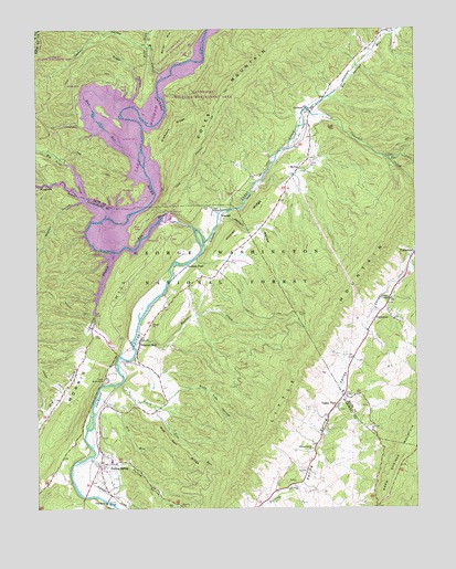
Falling Spring, VA USGS Topographic Map
Click on map above to begin viewing in our Map Viewer.

This topographic map contains these locations and features:
Feature Name Type Latitude Longitude GNIS ID View Map
Big Lick CreekStreamN37.9510°W79.9770°1481749View Map
Board Tree RunStreamN37.9079°W79.9720°1481890View Map
Bolar DraftValleyN37.9883°W79.9587°1481911View Map
Bolar Flat Picnic Area and Launch RampLocaleN37.9940°W79.9489°1488507View Map
Bolar Mountain CampgroundLocaleN37.9860°W79.9712°1488539View Map
CallisonPopulated PlaceN37.9787°W79.9114°1482231View Map
Camp AppalachiaLocaleN37.9085°W79.9773°1482243View Map
CarlooverPopulated PlaceN37.9243°W79.8887°1494863View Map
Cascades CreekStreamN37.9793°W79.9101°1482359View Map
Cedar CreekStreamN37.9446°W79.9442°1482396View Map
Coles Mountain Fire TrailTrailN37.9707°W79.9442°1482643View Map
Coles Mountain Picnic AreaLocaleN37.9496°W79.9659°1488540View Map
Dry RunStreamN37.9040°W79.9806°1483134View Map
Emory ChurchChurchN37.9232°W79.9623°1483304View Map
Falling SpringPopulated PlaceN37.8865°W79.9795°1483355View Map
Falling Spring CreekStreamN37.8887°W79.9828°1502790View Map
Falling Spring Elementary SchoolSchoolN37.8873°W79.9754°1673688View Map
Falling Spring Presbyterian ChurchChurchN37.8885°W79.9767°1673689View Map
Falling Spring ValleyValleyN37.8803°W79.9128°1483358View Map
Fortney Boat Launch RampLocaleN37.9282°W79.9801°1488536View Map
Fortney BranchStreamN37.9415°W79.9739°1483506View Map
Gathright DamDamN37.9551°W79.9514°1489103View Map
Gathright DamDamN37.9515°W79.9553°1488564View Map
Greavers RidgeRidgeN37.9743°W79.9531°1483787View Map
GreenwoodPopulated PlaceN37.9540°W79.9664°1495619View Map
Greenwood (historical)Populated PlaceN37.9543°W79.9656°1673649View Map
Hemlock TrailTrailN37.9987°W79.9401°1484028View Map
Hoover CreekStreamN37.9176°W79.9678°1484205View Map
Hoover RidgeRidgeN37.9512°W79.9292°1484206View Map
Hot Springs RunStreamN37.9793°W79.9103°1484239View Map
Hughes CreekStreamN37.9512°W79.9770°1673691View Map
Hughes DraftValleyN37.9512°W79.9770°1484270View Map
Jarrett HollowValleyN37.9516°W79.9365°1484400View Map
Jenkins FordCrossingN37.9382°W79.9503°1495005View Map
Kelly BridgeBridgeN37.9529°W79.9653°1484537View Map
KincaidPopulated PlaceN37.9507°W79.9389°1495017View Map
Lake MoomawReservoirN37.9515°W79.9553°1502172View Map
Lemon HollowValleyN37.9957°W79.9629°1484775View Map
Little Mountain TrailTrailN37.9210°W79.9173°1488588View Map
Lodge TrailTrailN37.9798°W79.9973°1485028View Map
Mad Ann RidgeRidgeN37.8907°W79.9537°1485150View Map
McAllister BridgeBridgeN37.9426°W79.9717°1485252View Map
Medden HollowValleyN37.9554°W79.9848°1485347View Map
Mill CreekStreamN37.9876°W79.9573°1485430View Map
Mill HillSummitN37.9879°W79.9612°1495947View Map
Morris HillSummitN37.8998°W79.9892°1495067View Map
Morris Hill CampgroundLocaleN37.9337°W79.9717°1488537View Map
Morris Hill Picnic AreaLocaleN37.9468°W79.9592°1488538View Map
Mud RunStreamN37.9662°W79.9659°1485729View Map
Natural WellLocaleN37.9185°W79.9662°1485807View Map
Perkins PointPopulated PlaceN37.9618°W79.9684°1496075View Map
Sinking Spring ChurchChurchN37.8907°W79.9095°1487265View Map
Smith BridgeBridgeN37.8768°W79.9773°1487329View Map
Suck Lick HollowValleyN37.9062°W79.9533°1487681View Map
Sugar HollowValleyN37.9815°W79.9678°1487692View Map
The GorgeValleyN37.9479°W79.9471°1487828View Map
Union Chapel Presbyterian ChurchChurchN37.9296°W79.8834°1488053View Map
Valley ViewPopulated PlaceN37.9023°W79.9014°1495158View Map

Note: Coordinates in the location and feature list above are referenced to NAD83 datum.


Copyright (C) 2008-2024 Ryan Niemi / Sunset Dynamics ... All Rights Reserved