TopoQuest Logo
Do you find TopoQuest useful?
Help keep TopoQuest running and adding new maps/features by donating!
Bitcoin:  19c7KJd3qBynnjoSw5npx9KScwjBe4ifkT
Litecoin:  LXs6TkuXGGXo1vDsWCkWVdjQX94eUKd6ui
Home View Maps Find Maps Find Places Resources & Links


Fallon, Montana Topographic Map

USGS Map Title: Fallon, MT
USGS Map MRC: 46105G1
DRG (GeoTIFF) Download: o46105g1.tif


Neighboring USGS Topographic Map Quads:


  Hendrickson Coulee, MT  
46105H2
 

  Fallon NE, MT  
46105H1
 

  Marsh, MT  
46104H8
 

  Fallon SW, MT  
46105G2
 

  Fallon, MT  
46105G1
 

  Marsh SW, MT  
46104G8
 

  Flat Top Butte, MT  
46105F2
 

  Flat Top Butte NE, MT  
46105F1
 

  Mildred, MT  
46104F8


Map MRC Location:

N47°
W106°
N47°
W105°
H8 H7 H6 H5 H4 H3 H2 H1
G8 G7 G6 G5 G4 G3 G2 G1
F8 F7 F6 F5 F4 F3 F2 F1
E8 E7 E6 E5 E4 E3 E2 E1
D8 D7 D6 D5 D4 D3 D2 D1
C8 C7 C6 C5 C4 C3 C2 C1
B8 B7 B6 B5 B4 B3 B2 B1
A8 A7 A6 A5 A4 A3 A2 A1
N46°
W106°
N46°
W105°

Fallon, MT USGS 1:24K Topographic Map Preview:
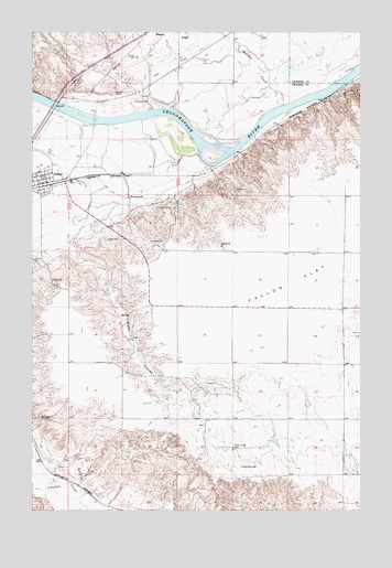
Fallon, MT USGS Topographic Map
Click on map above to begin viewing in our Map Viewer.

This topographic map contains these locations and features:
Feature Name Type Latitude Longitude GNIS ID View Map
12N52E25BA__01 WellWellN46.7714°W105.1250°818200View Map
12N53E04BB__01 WellWellN46.8300°W105.0680°818647View Map
12N53E23CA__01 WellWellN46.7792°W105.0208°818253View Map
12N53E23CA__02 WellWellN46.7792°W105.0208°818254View Map
12N53E23CDBA01 WellWellN46.7772°W105.0208°818236View Map
13N52E24DBCB01 WellWellN46.8664°W105.0800°818938View Map
13N52E24DCA_01 WellWellN46.8642°W105.0772°818923View Map
13N52E25BAAB01 WellWellN46.8608°W105.0828°818879View Map
13N52E25BDA_01 WellWellN46.8570°W105.0825°818843View Map
13N52E34CBDC01 WellWellN46.8358°W105.1250°818686View Map
13N52E34CDAD01 WellWellN46.8345°W105.1236°818677View Map
13N53E19CBA_01 WellWellN46.8683°W105.0678°818951View Map
13N53E19DBA_01 WellWellN46.8683°W105.0572°818950View Map
13N53E19DDC_01 WellWellN46.8628°W105.0544°818906View Map
13N53E20AAC_01 WellWellN46.8736°W105.0330°818995View Map
13N53E20DCA_01 WellWellN46.8647°W105.0358°818930View Map
13N53E22BAA_03 WellWellN46.8736°W105.0011°818994View Map
13N53E22BAC_01 WellWellN46.8736°W105.0011°818993View Map
13N53E29ACB_01 WellWellN46.8575°W105.0383°818848View Map
13N53E29ACC_01 WellWellN46.8556°W105.0383°818822View Map
13N53E29BBC_01 WellWellN46.8592°W105.0491°818869View Map
13N53E29BCD_01 WellWellN46.8556°W105.0464°818823View Map
13N53E29BCD_02 WellWellN46.8556°W105.0464°818824View Map
13N53E29BCD_03 WellWellN46.8556°W105.0464°818825View Map
13N53E29BDA_01 WellWellN46.8575°W105.0411°818849View Map
13N53E29BDB_01 WellWellN46.8575°W105.0439°818850View Map
13N53E29CAB_01 WellWellN46.8536°W105.0439°818814View Map
13N53E29CBB_01 WellWellN46.8536°W105.0491°818815View Map
13N53E29CBC_01 WellWellN46.8520°W105.0491°818792View Map
13N53E30ADD_01 WellWellN46.8556°W105.0516°818826View Map
13N53E30BBB_01 WellWellN46.8611°W105.0705°818881View Map
13N53E30DABC01 WellWellN46.8528°W105.0539°818806View Map
13N53E30DDB_01 WellWellN46.8500°W105.0544°818769View Map
Barrs BluffsCliffN46.8528°W105.0172°1715839View Map
Danton (historical)LocaleN46.8556°W105.0794°1715663View Map
Danton Post Office (historical)Post OfficeN46.8556°W105.0794°1715664View Map
De Russys RapidsRapidsN46.8528°W105.0366°1715844View Map
Evangelical Church of North AmericaChurchN46.8356°W105.1194°1715766View Map
FallonLocaleN46.8350°W105.1214°1715661View Map
FallonPopulated PlaceN46.8356°W105.1194°771300View Map
Fallon Bridge Fishing Access SiteLocaleN46.8567°W105.1147°1744404View Map
Fallon FlatFlatN46.8100°W105.0261°771302View Map
Fallon HallLocaleN46.8350°W105.1244°1715763View Map
Fallon Post OfficePost OfficeN46.8354°W105.1213°1715660View Map
Fallon Rural Fire DistrictBuildingN46.8361°W105.1208°2546694View Map
Fallon School (historical)SchoolN46.8328°W105.1236°1715692View Map
Grace Lutheran ParishChurchN46.8356°W105.1194°1715767View Map
Harvest States Cooperatives ElevatorLocaleN46.8345°W105.1233°1715765View Map
Hatchet CreekStreamN46.8558°W105.0291°772195View Map
Hope American Lutheran ChurchChurchN46.8356°W105.1194°1715762View Map
Little Flat School (historical)SchoolN46.7847°W105.0905°1715713View Map
Plum CouleeValleyN46.8200°W105.1105°775300View Map
Sackman School (historical)SchoolN46.7781°W105.0200°1715729View Map
Saucer Number 1 DamDamN46.7683°W105.0322°797479View Map
Thorson School (historical)SchoolN46.8242°W105.0483°1715743View Map
Walther ParkParkN46.8372°W105.1211°1715764View Map
Yellowstone River BridgeBridgeN46.8556°W105.1164°1715759View Map

Note: Coordinates in the location and feature list above are referenced to NAD83 datum.


Copyright (C) 2008-2025 Ryan Niemi / Sunset Dynamics ... All Rights Reserved