TopoQuest Logo
Do you find TopoQuest useful?
Help keep TopoQuest running and adding new maps/features by donating!
Bitcoin:  19c7KJd3qBynnjoSw5npx9KScwjBe4ifkT
Litecoin:  LXs6TkuXGGXo1vDsWCkWVdjQX94eUKd6ui
Home View Maps Find Maps Find Places Resources & Links


Marsh, Montana Topographic Map

USGS Map Title: Marsh, MT
USGS Map MRC: 46104H8
DRG (GeoTIFF) Download: o46104h8.tif


Neighboring USGS Topographic Map Quads:


  Upper Cracker Box School, MT  
47105A1
 

  Pleasant View, MT  
47104A8
 

  Forest Park, MT  
47104A7
 

  Fallon NE, MT  
46105H1
 

  Marsh, MT  
46104H8
 

  Hoyt, MT  
46104H7
 

  Fallon, MT  
46105G1
 

  Marsh SW, MT  
46104G8
 

  Simons Butte, MT  
46104G7


Map MRC Location:

N47°
W105°
N47°
W104°
H8 H7 H6 H5 H4 H3 H2 H1
G8 G7 G6 G5 G4 G3 G2 G1
F8 F7 F6 F5 F4 F3 F2 F1
E8 E7 E6 E5 E4 E3 E2 E1
D8 D7 D6 D5 D4 D3 D2 D1
C8 C7 C6 C5 C4 C3 C2 C1
B8 B7 B6 B5 B4 B3 B2 B1
A8 A7 A6 A5 A4 A3 A2 A1
N46°
W105°
N46°
W104°

Marsh, MT USGS 1:24K Topographic Map Preview:
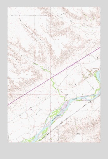
Marsh, MT USGS Topographic Map
Click on map above to begin viewing in our Map Viewer.

This topographic map contains these locations and features:
Feature Name Type Latitude Longitude GNIS ID View Map
13N53E01AAC_01 WellWellN46.9172°W104.9477°819362View Map
13N53E01ADD_01 WellWellN46.9136°W104.9450°819347View Map
13N53E01CBC_01 WellWellN46.9100°W104.9639°819327View Map
13N53E01CC__01 WellWellN46.9072°W104.9625°819317View Map
13N53E01CDC_01 WellWellN46.9064°W104.9583°819313View Map
13N53E01CDDD01 WellWellN46.9058°W104.9547°819310View Map
13N53E02DDCD01 WellWellN46.9056°W104.9675°819309View Map
13N53E06BC__01 WellWellN46.9147°W104.9402°819349View Map
13N53E10ACD_01 WellWellN46.8992°W104.9930°819261View Map
13N53E10ADA_01 WellWellN46.9008°W104.9877°819270View Map
13N53E10CDB_01 WellWellN46.8917°W104.9983°819183View Map
13N53E10DBC_01 WellWellN46.8953°W104.9958°819224View Map
13N53E10DBC_02 WellWellN46.8936°W104.9930°819204View Map
13N53E10DCA_01 WellWellN46.8917°W104.9905°819182View Map
13N53E10DD__01 WellWellN46.8928°W104.9891°819197View Map
13N53E11ACC_01 WellWellN46.8992°W104.9744°819260View Map
13N53E11ACC_02 WellWellN46.9045°W104.9772°819294View Map
13N53E11BAA_01 WellWellN46.9045°W104.9772°819293View Map
13N53E11BAA_02 WellWellN46.8972°W104.9850°819248View Map
13N53E11CA__01 WellWellN46.8964°W104.9783°819236View Map
13N53E11CBB_01 WellWellN46.8936°W104.9825°819203View Map
13N53E11CCA_01 WellWellN46.8917°W104.9825°819181View Map
13N53E11CCD_01 WellWellN46.8972°W104.9664°819246View Map
13N53E11DAA_01 WellWellN46.8972°W104.9744°819247View Map
13N53E11DBB_01 WellWellN46.8917°W104.9664°819180View Map
13N53E11DDD_01 WellWellN46.9045°W104.9530°819292View Map
13N53E12AAC_02 WellWellN46.8881°W104.9611°819132View Map
13N53E12AB__01 WellWellN46.9036°W104.9516°819288View Map
13N53E12ABB_01 WellWellN46.9008°W104.9505°819267View Map
13N53E12ACA_01 WellWellN46.9008°W104.9530°819268View Map
13N53E12ACB_02 WellWellN46.9008°W104.9530°819269View Map
13N53E12ACB_03 WellWellN46.8992°W104.9530°819259View Map
13N53E12ACC_01 WellWellN46.9028°W104.9477°819281View Map
13N53E12CBCD01 WellWellN46.8942°W104.9630°819210View Map
13N53E13BBD_01 WellWellN46.8900°W104.9797°819155View Map
13N53E14BAB_01 WellWellN46.8881°W104.9797°819133View Map
13N53E14BAC_02 WellWellN46.8864°W104.9797°819107View Map
13N53E14BDB_01 WellWellN46.8845°W104.9797°819088View Map
13N53E14BDC_01 WellWellN46.8828°W104.9772°819068View Map
13N53E14CAA_01 WellWellN46.8828°W104.9825°819069View Map
13N53E14CBA_01 WellWellN46.8828°W104.9850°819071View Map
13N53E14CBB_01 WellWellN46.8808°W104.9850°819046View Map
13N53E14CBBD01 WellWellN46.8817°W104.9827°819059View Map
13N53E14CBC_02 WellWellN46.8808°W104.9850°819047View Map
13N53E14CBC_03 WellWellN46.8828°W104.9825°819070View Map
13N53E14CBD_01 WellWellN46.8792°W104.9825°819025View Map
13N53E14CCA_01 WellWellN46.8808°W104.9691°819045View Map
13N53E14CDB_01 WellWellN46.8792°W104.9797°819024View Map
13N53E15AAB_01 WellWellN46.8900°W104.9905°819156View Map
13N53E15AAB_02 WellWellN46.8900°W104.9905°819157View Map
13N53E15AAC_01 WellWellN46.8881°W104.9905°819134View Map
13N53E15AAC_02 WellWellN46.8881°W104.9905°819135View Map
13N53E15AAC_03 WellWellN46.8881°W104.9905°819136View Map
13N53E15AAC_04 WellWellN46.8881°W104.9905°819137View Map
13N53E15AAC_05 WellWellN46.8881°W104.9905°819138View Map
13N53E15AAC_06 WellWellN46.8881°W104.9905°819139View Map
13N53E15AAC_07 WellWellN46.8881°W104.9958°819140View Map
13N53E15ABC_01 WellWellN46.8864°W104.9930°819109View Map
13N53E15ACA_01 WellWellN46.8845°W104.9930°819090View Map
13N53E15ACD_01 WellWellN46.8864°W104.9877°819108View Map
13N53E15ADD_01 WellWellN46.8845°W104.9877°819089View Map
13N53E15ADD_02 WellWellN46.8900°W104.9983°819158View Map
13N53E15CAB_04 WellWellN46.8808°W104.9983°819054View Map
13N53E15CAD_01 WellWellN46.8792°W104.9983°819032View Map
13N53E15CDA_01 WellWellN46.8828°W104.9877°819072View Map
13N53E15DAA_01 WellWellN46.8828°W104.9905°819073View Map
13N53E15DAB_02 WellWellN46.8828°W104.9905°819074View Map
13N53E15DAB_03 WellWellN46.8808°W104.9905°819052View Map
13N53E15DAC_01 WellWellN46.8808°W104.9905°819051View Map
13N53E15DAC_02 WellWellN46.8808°W104.9877°819049View Map
13N53E15DAD_01 WellWellN46.8808°W104.9877°819048View Map
13N53E15DAD_03 WellWellN46.8808°W104.9877°819050View Map
13N53E15DAD_04 WellWellN46.8808°W104.9930°819053View Map
13N53E15DBD_01 WellWellN46.8792°W104.9930°819031View Map
13N53E15DCC_01 WellWellN46.8772°W104.9958°819017View Map
13N53E15DDB_01 WellWellN46.8792°W104.9905°819026View Map
13N53E15DDB_02 WellWellN46.8792°W104.9905°819027View Map
13N53E15DDB_03 WellWellN46.8792°W104.9905°819028View Map
13N53E15DDB_04 WellWellN46.8792°W104.9905°819029View Map
13N53E15DDB_05 WellWellN46.8792°W104.9905°819030View Map
13N53E15DDB_06 WellWellN46.8772°W104.9905°819016View Map
13N53E15DDC_01 WellWellN46.8756°W104.9905°819008View Map
13N53E22ABD_01 WellWellN46.8756°W104.9983°819009View Map
13N53E22BAA_02 WellWellN46.8756°W104.9983°819010View Map
13N53E22BAD_01 WellWellN46.9100°W104.9391°819326View Map
13N54E10BB__01 WellWellN46.9036°W104.8772°819287View Map
13N54E10BBBD01 WellWellN46.9039°W104.8777°819289View Map
13N54E18AC__01 WellWellN46.8856°W104.9297°819104View Map
13N54E18BAAC01 WellWellN46.8892°W104.9339°819150View Map
14N53E02CCBC01 WellWellN46.9942°W104.9847°820004View Map
14N53E02CCCC01 WellWellN46.9925°W104.9850°819995View Map
14N54E08CDDC01 WellWellN46.9778°W104.9127°819887View Map
14N54E08CDDC02 WellWellN46.9778°W104.9127°819888View Map
14N54E13AAAB01 WellWellN46.8972°W104.9958°819249View Map
14N54E18BCCA01 WellWellN46.9717°W104.9408°819846View Map
14N54E22CCBB01 WellWellN46.9514°W104.8775°819602View Map
14N54E28DD__01 WellWellN46.9367°W104.8839°819490View Map
14N54E31AD__01 WellWellN46.9281°W104.9236°819440View Map
14N54E32BADA01 WellWellN46.8895°W104.9116°819151View Map
14N54E32DC__01 WellWellN46.9208°W104.9077°819390View Map
14N54E33CB__01 WellWellN46.9245°W104.8972°819418View Map
14N54E33DBAD01 WellWellN46.9250°W104.8847°819422View Map
14N54E34CB__01 WellWellN46.9245°W104.8764°819417View Map
American Lutheran Church (historical)ChurchN46.8897°W104.9330°1715456View Map
Bagley Elevator (historical)LocaleN46.8897°W104.9330°1715406View Map
Cracker Box CreekStreamN46.9128°W104.9211°770265View Map
Dry CouleeValleyN46.9314°W104.8927°1715474View Map
Interchange 198CrossingN46.9478°W104.9108°1715624View Map
Jehovah Lutheran CemeteryCemeteryN46.8828°W104.9313°1955148View Map
Lower Crackerbox School (historical)SchoolN46.9928°W104.9847°1715554View Map
MarshPopulated PlaceN46.8897°W104.9330°801127View Map
Marsh CemeteryCemeteryN46.8828°W104.9311°1715460View Map
Marsh Post Office (historical)Post OfficeN46.8895°W104.9333°1715359View Map
Marsh School (historical)SchoolN46.8908°W104.9294°1715556View Map
Missouri Lutheran CemeteryCemeteryN46.8847°W104.9325°1955147View Map
North Fork Cracker Box CreekStreamN46.9414°W104.9466°799378View Map
Yale School (historical)SchoolN46.9008°W104.9839°778718View Map

Note: Coordinates in the location and feature list above are referenced to NAD83 datum.


Copyright (C) 2008-2025 Ryan Niemi / Sunset Dynamics ... All Rights Reserved