TopoQuest Logo
Do you find TopoQuest useful?
Help keep TopoQuest running and adding new maps/features by donating!
Bitcoin:  19c7KJd3qBynnjoSw5npx9KScwjBe4ifkT
Litecoin:  LXs6TkuXGGXo1vDsWCkWVdjQX94eUKd6ui
Home View Maps Find Maps Find Places Resources & Links


Fannettsburg, Pennsylvania Topographic Map

USGS Map Title: Fannettsburg, PA
USGS Map MRC: 40077A7
DRG (GeoTIFF) Download: o40077a7.tif


Neighboring USGS Topographic Map Quads:


  Orbisonia, PA  
40077B8
 

  Shade Gap, PA  
40077B7
 

  Doylesburg, PA  
40077B6
 

  Burnt Cabins, PA  
40077A8
 

  Fannettsburg, PA  
40077A7
 

  Roxbury, PA  
40077A6
 

  McConnellsburg, PA  
39077H8
 

  Saint Thomas, PA  
39077H7
 

  Chambersburg, PA  
39077H6


Map MRC Location:

N41°
W78°
N41°
W77°
H8 H7 H6 H5 H4 H3 H2 H1
G8 G7 G6 G5 G4 G3 G2 G1
F8 F7 F6 F5 F4 F3 F2 F1
E8 E7 E6 E5 E4 E3 E2 E1
D8 D7 D6 D5 D4 D3 D2 D1
C8 C7 C6 C5 C4 C3 C2 C1
B8 B7 B6 B5 B4 B3 B2 B1
A8 A7 A6 A5 A4 A3 A2 A1
N40°
W78°
N40°
W77°

Fannettsburg, PA USGS 1:24K Topographic Map Preview:
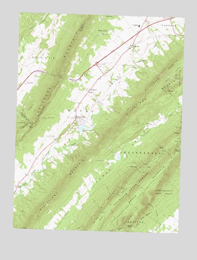
Fannettsburg, PA USGS Topographic Map
Click on map above to begin viewing in our Map Viewer.

This topographic map contains these locations and features:
Feature Name Type Latitude Longitude GNIS ID View Map
Bear ValleyValleyN40.0365°W77.7815°1168958View Map
Bear Valley Picnic AreaAreaN40.0351°W77.7805°1212834View Map
Berger TrailTrailN40.0515°W77.7530°1169291View Map
Big GapGapN40.0584°W77.7505°1169511View Map
BoggstownPopulated PlaceN40.0743°W77.8133°1196425View Map
Burnt Cabins Emergency Strip (historical)AirportN40.0834°W77.8622°1193826View Map
Carrick ValleyPopulated PlaceN40.0598°W77.8653°1203227View Map
Center SchoolSchoolN40.1206°W77.8619°1211434View Map
Center School (historical)SchoolN40.1209°W77.8617°1197076View Map
Cradle GapGapN40.0009°W77.7964°1172589View Map
Cree CemeteryCemeteryN40.0982°W77.8660°2026370View Map
DecorumPopulated PlaceN40.1009°W77.8572°1211124View Map
Dothan ValleyValleyN40.0827°W77.7613°1173405View Map
Fannett-Metal High SchoolSchoolN40.1193°W77.7842°1174612View Map
FannettsburgPopulated PlaceN40.0651°W77.8294°1174613View Map
Fannettsburg Post OfficePost OfficeN40.0667°W77.8292°2779906View Map
FreestonePopulated PlaceN40.0151°W77.8336°1211275View Map
Fry TrailTrailN40.0104°W77.7844°1175310View Map
Green Spring TrailTrailN40.0254°W77.7769°1176116View Map
Hoovers BridgeBridgeN40.0954°W77.7867°1177372View Map
Hoovers MillLocaleN40.0793°W77.7858°1211122View Map
Horse Valley CemeteryCemeteryN40.0389°W77.8055°1177452View Map
Horse Valley ChurchChurchN40.0409°W77.8083°1177453View Map
Keefer Church (historical)ChurchN40.0401°W77.8089°1211120View Map
Keefer GapGapN40.0379°W77.7819°1178280View Map
Kittatinny MountainRangeN40.0248°W77.8383°1190981View Map
Kuhns MillLocaleN40.1012°W77.7717°1211121View Map
Lehman TrailTrailN40.0445°W77.7578°1179167View Map
Little Mountain TrailTrailN40.0176°W77.8039°1206764View Map
Lookout TrailTrailN40.0348°W77.7742°1179933View Map
Lower Path Valley CemeteryCemeteryN40.0533°W77.8448°1180026View Map
Mackey TrailTrailN40.0156°W77.8125°1180161View Map
Marshall HollowValleyN40.0065°W77.7633°1180469View Map
McKinley SchoolSchoolN40.0901°W77.8656°1211123View Map
Metal ChurchChurchN40.0240°W77.8725°1180973View Map
Metal Township Fire and Ambulance Department - Company 21BuildingN40.0659°W77.8290°2645058View Map
Mountain GreenPopulated PlaceN40.1168°W77.8119°1192977View Map
Mountain LakeReservoirN40.0593°W77.8241°1192978View Map
Mountain Lake CampLocaleN40.0587°W77.8292°1192979View Map
Rexroth TrailTrailN40.0434°W77.7805°1206739View Map
Shady Pine ChurchChurchN40.1140°W77.8128°1187308View Map
Skinner GapGapN40.0487°W77.7658°1187756View Map
Smith TrailTrailN40.0406°W77.7655°1187894View Map
SpringtownPopulated PlaceN40.0806°W77.8197°1204710View Map
StengerLocaleN40.0662°W77.7639°1212833View Map
Stephanies RunStreamN40.0481°W77.8449°2790946View Map
The NarrowsGapN40.0815°W77.7608°1189427View Map
Thomas TrailTrailN40.0231°W77.8036°1189489View Map
Township of MetalCivilN40.0430°W77.8479°1216466View Map
Tuscarora TunnelTunnelN40.0893°W77.8450°1189985View Map
Twomile TrailTrailN40.0104°W77.7997°1190033View Map
W H WalkerDamN40.0584°W77.8264°1194517View Map
Weaver GapGapN40.0029°W77.7883°1190737View Map
Willow HillPopulated PlaceN40.1081°W77.7883°1191503View Map
Willow Hill Post OfficePost OfficeN40.1124°W77.7865°2773048View Map

Note: Coordinates in the location and feature list above are referenced to NAD83 datum.


Copyright (C) 2008-2024 Ryan Niemi / Sunset Dynamics ... All Rights Reserved