TopoQuest Logo
Do you find TopoQuest useful?
Help keep TopoQuest running and adding new maps/features by donating!
Bitcoin:  19c7KJd3qBynnjoSw5npx9KScwjBe4ifkT
Litecoin:  LXs6TkuXGGXo1vDsWCkWVdjQX94eUKd6ui
Home View Maps Find Maps Find Places Resources & Links


Roxbury, Pennsylvania Topographic Map

USGS Map Title: Roxbury, PA
USGS Map MRC: 40077A6
DRG (GeoTIFF) Download: o40077a6.tif


Neighboring USGS Topographic Map Quads:


  Shade Gap, PA  
40077B7
 

  Doylesburg, PA  
40077B6
 

  Newburg, PA  
40077B5
 

  Fannettsburg, PA  
40077A7
 

  Roxbury, PA  
40077A6
 

  Shippensburg, PA  
40077A5
 

  Saint Thomas, PA  
39077H7
 

  Chambersburg, PA  
39077H6
 

  Scotland, PA  
39077H5


Map MRC Location:

N41°
W78°
N41°
W77°
H8 H7 H6 H5 H4 H3 H2 H1
G8 G7 G6 G5 G4 G3 G2 G1
F8 F7 F6 F5 F4 F3 F2 F1
E8 E7 E6 E5 E4 E3 E2 E1
D8 D7 D6 D5 D4 D3 D2 D1
C8 C7 C6 C5 C4 C3 C2 C1
B8 B7 B6 B5 B4 B3 B2 B1
A8 A7 A6 A5 A4 A3 A2 A1
N40°
W78°
N40°
W77°

Roxbury, PA USGS 1:24K Topographic Map Preview:
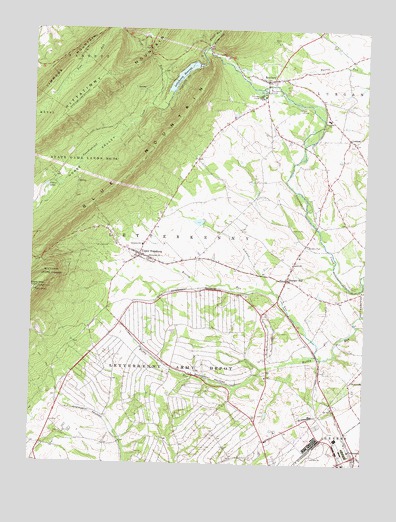
Roxbury, PA USGS Topographic Map
Click on map above to begin viewing in our Map Viewer.

This topographic map contains these locations and features:
Feature Name Type Latitude Longitude GNIS ID View Map
Air Hill ChurchChurchN40.0165°W77.6361°1168094View Map
Benders ParkParkN40.0637°W77.6467°1169232View Map
Blue MountainRangeN40.1245°W77.6664°1193708View Map
Camp JohnsonLocaleN40.1023°W77.6497°1171035View Map
Cedar LakeLakeN40.0796°W77.7446°1171387View Map
Clarks KnobSummitN40.0501°W77.7478°1192270View Map
Dothan RunStreamN40.0715°W77.7469°1192366View Map
Elm Grove SchoolSchoolN40.0543°W77.6853°1211016View Map
Emmanuel ChurchChurchN40.0595°W77.7055°1174228View Map
Fairview SchoolSchoolN40.0873°W77.6880°1211430View Map
Gelvin SchoolSchoolN40.0123°W77.6650°1211018View Map
Gunter ValleyValleyN40.1209°W77.6849°1176321View Map
Holiness CampLocaleN40.1059°W77.6628°1177201View Map
Horse ValleyValleyN40.1202°W77.6851°1177450View Map
Keasey RunStreamN40.0501°W77.6589°1178269View Map
KeefersPopulated PlaceN40.0029°W77.7472°1211019View Map
Lehman RunStreamN40.0318°W77.6417°1179165View Map
Letterkenny Army DepotMilitaryN40.0187°W77.6972°2512259View Map
Letterkenny ReservoirReservoirN40.1117°W77.6943°1179223View Map
LurganPopulated PlaceN40.0940°W77.6311°1180081View Map
Maple GrovePopulated PlaceN40.0270°W77.7414°1211021View Map
Pine RunStreamN40.1029°W77.7050°1183873View Map
Pleasant HallPopulated PlaceN40.0531°W77.6539°1184018View Map
Pleasant Hall Post OfficePost OfficeN40.0535°W77.6542°2779589View Map
Pleasant Hall Volunteer Fire Department - Company 11BuildingN40.0538°W77.6531°2645164View Map
Pleasant Hill SchoolSchoolN40.0118°W77.7230°1211020View Map
RoxburyPopulated PlaceN40.1104°W77.6619°1185584View Map
Roxbury Post OfficePost OfficeN40.1107°W77.6580°2772954View Map
Salem ChurchChurchN40.0579°W77.6514°1186817View Map
Sandy Mount SchoolSchoolN40.0845°W77.6636°1211015View Map
Shearer SchoolSchoolN40.0693°W77.6314°1211028View Map
Spud View AirportAirportN40.0656°W77.6927°2442797View Map
State Game Lands Number 76ParkN40.0865°W77.7286°1188532View Map
Timmons MountainSummitN40.1137°W77.7383°1193534View Map
Township of LetterkennyCivilN40.0422°W77.7240°1216464View Map
Township of LurganCivilN40.1197°W77.6282°1216465View Map
Trout RunStreamN40.1201°W77.6836°1189860View Map
Union SchoolSchoolN40.0284°W77.6405°1211017View Map
Upper StrasburgPopulated PlaceN40.0604°W77.7089°1190256View Map
Upper Strasburg Post OfficePost OfficeN40.0608°W77.7123°2779629View Map

Note: Coordinates in the location and feature list above are referenced to NAD83 datum.


Copyright (C) 2008-2024 Ryan Niemi / Sunset Dynamics ... All Rights Reserved