TopoQuest Logo
Do you find TopoQuest useful?
Help keep TopoQuest running and adding new maps/features by donating!
Bitcoin:  19c7KJd3qBynnjoSw5npx9KScwjBe4ifkT
Litecoin:  LXs6TkuXGGXo1vDsWCkWVdjQX94eUKd6ui
Home View Maps Find Maps Find Places Resources & Links


Doylesburg, Pennsylvania Topographic Map

USGS Map Title: Doylesburg, PA
USGS Map MRC: 40077B6
DRG (GeoTIFF) Download: o40077b6.tif


Neighboring USGS Topographic Map Quads:


  Aughwick, PA  
40077C7
 

  Blairs Mills, PA  
40077C6
 

  Blain, PA  
40077C5
 

  Shade Gap, PA  
40077B7
 

  Doylesburg, PA  
40077B6
 

  Newburg, PA  
40077B5
 

  Fannettsburg, PA  
40077A7
 

  Roxbury, PA  
40077A6
 

  Shippensburg, PA  
40077A5


Map MRC Location:

N41°
W78°
N41°
W77°
H8 H7 H6 H5 H4 H3 H2 H1
G8 G7 G6 G5 G4 G3 G2 G1
F8 F7 F6 F5 F4 F3 F2 F1
E8 E7 E6 E5 E4 E3 E2 E1
D8 D7 D6 D5 D4 D3 D2 D1
C8 C7 C6 C5 C4 C3 C2 C1
B8 B7 B6 B5 B4 B3 B2 B1
A8 A7 A6 A5 A4 A3 A2 A1
N40°
W78°
N40°
W77°

Doylesburg, PA USGS 1:24K Topographic Map Preview:
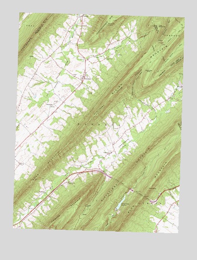
Doylesburg, PA USGS Topographic Map
Click on map above to begin viewing in our Map Viewer.

This topographic map contains these locations and features:
Feature Name Type Latitude Longitude GNIS ID View Map
AmbersonPopulated PlaceN40.1704°W77.6772°1168249View Map
Amberson Post OfficePost OfficeN40.1706°W77.6770°2773063View Map
Amberson ValleyValleyN40.1613°W77.7063°1168251View Map
Amberson Valley EstatesPopulated PlaceN40.2037°W77.6322°1212832View Map
Barnhart TrailTrailN40.2431°W77.6511°1192096View Map
Bear Pond TrailTrailN40.2304°W77.6500°1168905View Map
Blue Mountain TunnelTunnelN40.1456°W77.6528°1169890View Map
Burns CreekStreamN40.2279°W77.7155°1170733View Map
Burns SchoolSchoolN40.2251°W77.6964°1211031View Map
Burns ValleyValleyN40.2237°W77.6970°1170742View Map
Burns Valley ChurchChurchN40.2251°W77.6819°1170743View Map
Catholic PathTrailN40.1973°W77.6769°1206512View Map
Clay Hill SchoolSchoolN40.1409°W77.6305°1196417View Map
Concord Post OfficePost OfficeN40.2495°W77.7018°2772644View Map
DoylesburgPopulated PlaceN40.2134°W77.7000°1173439View Map
DoylestownPopulated PlaceN40.1976°W77.7214°1203441View Map
Doylestown StreamStreamN40.2279°W77.7155°1173440View Map
Drillmore Acres AirportAirportN40.1265°W77.6350°2442785View Map
Eckenrode KnobSummitN40.2173°W77.6503°1173968View Map
Felty Stewart RunStreamN40.1887°W77.6450°1174679View Map
Gunter Valley DamDamN40.1401°W77.6714°1194574View Map
Gunter Valley ReservoirReservoirN40.1410°W77.6693°1176322View Map
Hayes SchoolSchoolN40.2176°W77.7350°1196416View Map
Hemlocks Natural AreaAreaN40.2384°W77.6414°1201697View Map
Horseshoe LakeReservoirN40.2091°W77.6277°1177463View Map
Kittatinny TunnelTunnelN40.1534°W77.6703°1178572View Map
Knob MountainSummitN40.1404°W77.7405°1211707View Map
Laurel GrovePopulated PlaceN40.1526°W77.7105°1178935View Map
Linns PointSummitN40.1501°W77.6486°1180129View Map
Little Round TopSummitN40.2454°W77.6447°1179661View Map
Mill Run SchoolSchoolN40.1959°W77.6472°1196418View Map
NewbridgePopulated PlaceN40.1468°W77.7264°1204281View Map
Patterson Run TrailTrailN40.2465°W77.6275°1193092View Map
Rising MountainSummitN40.2190°W77.6605°1193194View Map
Round TopSummitN40.2448°W77.6828°1185544View Map
Saint Marys ChurchChurchN40.2143°W77.7055°1186411View Map
Stewart Narrows TrailTrailN40.2218°W77.6519°1193469View Map
Sugarcamp HollowValleyN40.2001°W77.6552°1188984View Map
Township of FannettCivilN40.1878°W77.7097°1216460View Map
Tuscarora MountainRangeN40.2368°W77.7383°1193565View Map
United Presbyterian CemeteryCemeteryN40.2437°W77.7026°1190196View Map
Wolfe SchoolSchoolN40.1304°W77.7447°1211030View Map

Note: Coordinates in the location and feature list above are referenced to NAD83 datum.


Copyright (C) 2008-2024 Ryan Niemi / Sunset Dynamics ... All Rights Reserved