TopoQuest Logo
Do you find TopoQuest useful?
Help keep TopoQuest running and adding new maps/features by donating!
Bitcoin:  19c7KJd3qBynnjoSw5npx9KScwjBe4ifkT
Litecoin:  LXs6TkuXGGXo1vDsWCkWVdjQX94eUKd6ui
Home View Maps Find Maps Find Places Resources & Links


Felton, Georgia Topographic Map

USGS Map Title: Felton, GA
USGS Map MRC: 33085H2
DRG (GeoTIFF) Download: o33085h2.tif


Neighboring USGS Topographic Map Quads:


  Cedartown West, GA  
34085A3
 

  Cedartown East, GA  
34085A2
 

  Rockmart North, GA  
34085A1
 

  Benedict, GA  
33085H3
 

  Felton, GA  
33085H2
 

  Rockmart South, GA  
33085H1
 

  Tallapoosa North, GA  
33085G3
 

  Buchanan, GA  
33085G2
 

  Draketown, GA  
33085G1


Map MRC Location:

N34°
W86°
N34°
W85°
H8 H7 H6 H5 H4 H3 H2 H1
G8 G7 G6 G5 G4 G3 G2 G1
F8 F7 F6 F5 F4 F3 F2 F1
E8 E7 E6 E5 E4 E3 E2 E1
D8 D7 D6 D5 D4 D3 D2 D1
C8 C7 C6 C5 C4 C3 C2 C1
B8 B7 B6 B5 B4 B3 B2 B1
A8 A7 A6 A5 A4 A3 A2 A1
N33°
W86°
N33°
W85°

Felton, GA USGS 1:24K Topographic Map Preview:
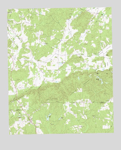
Felton, GA USGS Topographic Map
Click on map above to begin viewing in our Map Viewer.

This topographic map contains these locations and features:
Feature Name Type Latitude Longitude GNIS ID View Map
AntiochPopulated PlaceN33.9534°W85.1613°354322View Map
Antioch ChurchChurchN33.9534°W85.1636°354363View Map
Antioch School (historical)SchoolN33.9515°W85.1638°343519View Map
Becks LakeReservoirN33.9929°W85.1348°311016View Map
Bethlehem ChurchChurchN33.9943°W85.1430°354683View Map
Big Cedar Creek Structure Number 50 DamDamN33.9268°W85.1933°337623View Map
Biggers School (historical)SchoolN33.9876°W85.1769°343526View Map
Bordens CreekStreamN33.9470°W85.1322°310336View Map
Camp AntiochLocaleN33.9515°W85.1636°312190View Map
Cedar Rock LakeReservoirN33.9447°W85.1873°355066View Map
Cedar Rock Lake DamDamN33.9462°W85.1866°337635View Map
Center ChurchChurchN33.8915°W85.2238°312510View Map
Cobb MountainSummitN33.9095°W85.1988°312788View Map
Davis LakeReservoirN33.9393°W85.1555°337620View Map
Euharlee Creek Structure Number 51 DamDamN33.9351°W85.1266°339097View Map
Euharlee Creek Structure Number 76 DamDamN33.9384°W85.1349°337625View Map
Euharlee Creek Structure Number Four DamDamN33.9401°W85.1533°337619View Map
Everett SpringsSpringN33.9520°W85.1324°313999View Map
FeltonPopulated PlaceN33.8882°W85.2236°326274View Map
Felton CemeteryCemeteryN33.8884°W85.2233°350630View Map
Felton Junior High School (historical)SchoolN33.8845°W85.2258°350631View Map
Felton Post OfficePost OfficeN33.8865°W85.2238°350703View Map
FishPopulated PlaceN33.9987°W85.1408°331710View Map
Freedom ChurchChurchN33.9548°W85.2441°343558View Map
Friendly Baptist ChurchChurchN33.9923°W85.2322°343559View Map
Friendship ChurchChurchN33.9882°W85.1763°314428View Map
Haralson County Fire Department Station 11BuildingN33.8866°W85.2240°2604048View Map
Haralson County Fire Department Station 3BuildingN33.9020°W85.1774°2604535View Map
Hickman Junction (historical)LocaleN33.9382°W85.2111°343568View Map
Hightower CemeteryCemeteryN33.9493°W85.1545°2119855View Map
Hightower FallsFallsN33.9343°W85.1441°315403View Map
Hightower LakeReservoirN33.9286°W85.1406°315406View Map
Hightower Lake Dam Number OneDamN33.9312°W85.1427°337629View Map
Hightower Mill (historical)LocaleN33.9357°W85.1444°343569View Map
Hightower MountainSummitN33.9190°W85.1619°356293View Map
Hobson LakeReservoirN33.9297°W85.1659°337632View Map
Hobson Lake DamDamN33.9301°W85.1666°337631View Map
Lees ChapelChurchN33.9657°W85.2047°356351View Map
Lindsey LakeReservoirN33.9268°W85.1925°337624View Map
Little Cedar CreekStreamN33.9459°W85.2158°316986View Map
Lower Hightower Falls LakeReservoirN33.9384°W85.1363°337626View Map
Mount Zion East ChurchChurchN33.8818°W85.1619°319042View Map
Mount Zion East Church CemeteryCemeteryN33.8825°W85.1622°2080408View Map
Mountain View ChurchChurchN33.8909°W85.1486°319086View Map
Mountain View School (historical)SchoolN33.8912°W85.1486°350654View Map
North Watts LakeReservoirN33.8942°W85.2010°339938View Map
North Watts Lake DamDamN33.8934°W85.2016°339937View Map
Philpott SpringSpringN33.9976°W85.2497°343582View Map
Polk County Fire Department Youngs StationBuildingN33.9402°W85.2427°2603989View Map
Polk County Volunteer Fire Department Antioch StationBuildingN33.9521°W85.1524°2604619View Map
Rainey LakeReservoirN33.8901°W85.1893°321287View Map
Saint Johns CemeteryCemeteryN33.9537°W85.1466°322103View Map
Salem Church (historical)ChurchN33.9395°W85.2255°343596View Map
Southside ChurchChurchN33.8865°W85.2247°323302View Map
Ten Oaks LakeReservoirN33.8930°W85.2371°323989View Map
Union Grove ChurchChurchN33.8845°W85.2000°324555View Map
Watts LakesReservoirN33.8904°W85.2034°324926View Map
Winkles (historical)Populated PlaceN33.9120°W85.2402°343611View Map
YoungsPopulated PlaceN33.9479°W85.2233°343612View Map
Youngs Grove ChurchChurchN33.9484°W85.2152°325646View Map
Youngs SpringSpringN33.9454°W85.2169°343613View Map

Note: Coordinates in the location and feature list above are referenced to NAD83 datum.


Copyright (C) 2008-2024 Ryan Niemi / Sunset Dynamics ... All Rights Reserved