TopoQuest Logo
Do you find TopoQuest useful?
Help keep TopoQuest running and adding new maps/features by donating!
Bitcoin:  19c7KJd3qBynnjoSw5npx9KScwjBe4ifkT
Litecoin:  LXs6TkuXGGXo1vDsWCkWVdjQX94eUKd6ui
Home View Maps Find Maps Find Places Resources & Links


Ferron Canyon, Utah Topographic Map

USGS Map Title: Ferron Canyon, UT
USGS Map MRC: 39111B3
DRG (GeoTIFF) Download: o39111b3.tif


Neighboring USGS Topographic Map Quads:


  Danish Knoll, UT  
39111C4
 

  Joes Valley Reservoir, UT  
39111C3
 

  Mahogany Point, UT  
39111C2
 

  Ferron Reservoir, UT  
39111B4
 

  Ferron Canyon, UT  
39111B3
 

  The Cap, UT  
39111B2
 

  Heliotrope Mountain, UT  
39111A4
 

  Flagstaff Peak, UT  
39111A3
 

  Ferron, UT  
39111A2


Map MRC Location:

N40°
W112°
N40°
W111°
H8 H7 H6 H5 H4 H3 H2 H1
G8 G7 G6 G5 G4 G3 G2 G1
F8 F7 F6 F5 F4 F3 F2 F1
E8 E7 E6 E5 E4 E3 E2 E1
D8 D7 D6 D5 D4 D3 D2 D1
C8 C7 C6 C5 C4 C3 C2 C1
B8 B7 B6 B5 B4 B3 B2 B1
A8 A7 A6 A5 A4 A3 A2 A1
N39°
W112°
N39°
W111°

Ferron Canyon, UT USGS 1:24K Topographic Map Preview:
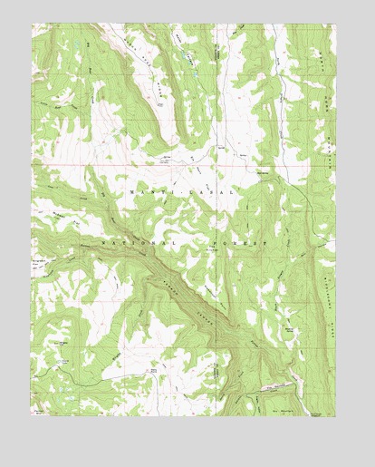
Ferron Canyon, UT USGS Topographic Map
Click on map above to begin viewing in our Map Viewer.

This topographic map contains these locations and features:
Feature Name Type Latitude Longitude GNIS ID View Map
Biddlecome RidgeRidgeN39.1566°W111.2529°1438628View Map
Big Bear CreekStreamN39.1755°W111.3271°1438633View Map
Black Dragon CreekStreamN39.1389°W111.2704°1438843View Map
Bull HollowValleyN39.1730°W111.2702°1439270View Map
Cove CreekStreamN39.1905°W111.3438°1440065View Map
Dairy CreekStreamN39.1466°W111.2821°1440230View Map
Dairy PointCapeN39.1394°W111.3266°1440235View Map
Dairy TrailTrailN39.1583°W111.3410°1440238View Map
Dugway HollowValleyN39.1319°W111.2832°1440710View Map
Elk Horn FlatFlatN39.2014°W111.3055°1440904View Map
Ferron CanyonValleyN39.1522°W111.2949°1441027View Map
Horn Mountain Cow CampLocaleN39.2055°W111.3188°1441855View Map
Little Bear CreekStreamN39.2200°W111.3513°1442662View Map
Lizard LakeLakeN39.1422°W111.3639°1442817View Map
Lone Pine SpringSpringN39.2105°W111.2963°1437891View Map
Lone TreeLocaleN39.2061°W111.2974°1451285View Map
Manti-La Sal National ForestForestN39.2015°W111.3438°1878747View Map
McEwan FlatFlatN39.1902°W111.3685°1443250View Map
Mud SpringSpringN39.2020°W111.2821°1443695View Map
Singleton CreekStreamN39.1786°W111.3530°1445610View Map
Steamboat PointCapeN39.1619°W111.2988°1446111View Map
Stevens CreekStreamN39.1355°W111.2663°1446140View Map
Stinking SpringSpringN39.1532°W111.2679°1446151View Map
The KitchenBasinN39.1769°W111.3010°1446465View Map
The NarrowsValleyN39.1350°W111.2699°1446481View Map
Water TerraceBenchN39.2452°W111.3141°1447068View Map
Wrigley CreekStreamN39.1694°W111.3199°1447536View Map
Wrigley HillSummitN39.1480°W111.3638°1447537View Map

Note: Coordinates in the location and feature list above are referenced to NAD83 datum.


Copyright (C) 2008-2025 Ryan Niemi / Sunset Dynamics ... All Rights Reserved