TopoQuest Logo
Do you find TopoQuest useful?
Help keep TopoQuest running and adding new maps/features by donating!
Bitcoin:  19c7KJd3qBynnjoSw5npx9KScwjBe4ifkT
Litecoin:  LXs6TkuXGGXo1vDsWCkWVdjQX94eUKd6ui
Home View Maps Find Maps Find Places Resources & Links


Finleyson East, Georgia Topographic Map

USGS Map Title: Finleyson East, GA
USGS Map MRC: 32083B4
DRG (GeoTIFF) Download: o32083b4.tif


Neighboring USGS Topographic Map Quads:


  Klondike, GA  
32083C5
 

  Hawkinsville, GA  
32083C4
 

  Empire, GA  
32083C3
 

  Finleyson West, GA  
32083B5
 

  Finleyson East, GA  
32083B4
 

  West of Eastman, GA  
32083B3
 

  Pineview West, GA  
32083A5
 

  Pineview East, GA  
32083A4
 

  Abbeville North, GA  
32083A3


Map MRC Location:

N33°
W84°
N33°
W83°
H8 H7 H6 H5 H4 H3 H2 H1
G8 G7 G6 G5 G4 G3 G2 G1
F8 F7 F6 F5 F4 F3 F2 F1
E8 E7 E6 E5 E4 E3 E2 E1
D8 D7 D6 D5 D4 D3 D2 D1
C8 C7 C6 C5 C4 C3 C2 C1
B8 B7 B6 B5 B4 B3 B2 B1
A8 A7 A6 A5 A4 A3 A2 A1
N32°
W84°
N32°
W83°

Finleyson East, GA USGS 1:24K Topographic Map Preview:
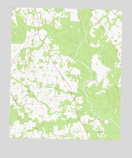
Finleyson East, GA USGS Topographic Map
Click on map above to begin viewing in our Map Viewer.

This topographic map contains these locations and features:
Feature Name Type Latitude Longitude GNIS ID View Map
Big CreekStreamN32.2127°W83.4235°354713View Map
Blue SpringsSpringN32.1688°W83.4788°311558View Map
Blue Springs ChurchChurchN32.1704°W83.4799°354789View Map
Bluff CreekStreamN32.1546°W83.4085°311568View Map
Bluff Creek CemeteryCemeteryN32.1421°W83.4616°311571View Map
Bohanon CemeteryCemeteryN32.2152°W83.3835°311624View Map
Cedar CreekStreamN32.2313°W83.4988°312462View Map
Cooks ChapelChurchN32.1388°W83.4157°355278View Map
Cotton BluffCliffN32.1877°W83.4068°347578View Map
Dawson LakeReservoirN32.1753°W83.4524°336196View Map
Dawson Lake DamDamN32.1752°W83.4499°336195View Map
Goose NeckPopulated PlaceN32.2485°W83.4521°331839View Map
Hartford DivisionCivilN32.2429°W83.3969°1936307View Map
Limestone CreekStreamN32.2354°W83.4177°316882View Map
Mosquito CreekStreamN32.1393°W83.3766°354249View Map
Pappy Jack SpringSpringN32.1352°W83.4671°320190View Map
Piney Grove ChurchChurchN32.2479°W83.4527°320709View Map
Pulaski CountyCivilN32.2323°W83.4760°347593View Map
Reedy CreekStreamN32.1399°W83.4393°321463View Map
Richland ChurchChurchN32.1254°W83.4602°321575View Map
Sandridge ChurchChurchN32.1735°W83.4491°322451View Map
Sapp CemeteryCemeteryN32.2499°W83.3874°322514View Map
Slade CemeteryCemeteryN32.2063°W83.4907°323065View Map
Standley CreekStreamN32.1729°W83.4166°323505View Map
Tenmile CreekStreamN32.1371°W83.4638°323995View Map
Treisch LakeLakeN32.1491°W83.4038°324284View Map
Union CemeteryCemeteryN32.2415°W83.4032°324492View Map
WallacePopulated PlaceN32.1971°W83.4971°326578View Map
Wolf CreekStreamN32.1432°W83.4777°325490View Map

Note: Coordinates in the location and feature list above are referenced to NAD83 datum.


Copyright (C) 2008-2025 Ryan Niemi / Sunset Dynamics ... All Rights Reserved