TopoQuest Logo
Do you find TopoQuest useful?
Help keep TopoQuest running and adding new maps/features by donating!
Bitcoin:  19c7KJd3qBynnjoSw5npx9KScwjBe4ifkT
Litecoin:  LXs6TkuXGGXo1vDsWCkWVdjQX94eUKd6ui
Home View Maps Find Maps Find Places Resources & Links


Abbeville North, Georgia Topographic Map

USGS Map Title: Abbeville North, GA
USGS Map MRC: 32083A3
DRG (GeoTIFF) Download: o32083a3.tif


Neighboring USGS Topographic Map Quads:


  Finleyson East, GA  
32083B4
 

  West of Eastman, GA  
32083B3
 

  Eastman, GA  
32083B2
 

  Pineview East, GA  
32083A4
 

  Abbeville North, GA  
32083A3
 

  Lake Cypress, GA  
32083A2
 

  Rochelle, GA  
31083H4
 

  Abbeville South, GA  
31083H3
 

  Rhine, GA  
31083H2


Map MRC Location:

N33°
W84°
N33°
W83°
H8 H7 H6 H5 H4 H3 H2 H1
G8 G7 G6 G5 G4 G3 G2 G1
F8 F7 F6 F5 F4 F3 F2 F1
E8 E7 E6 E5 E4 E3 E2 E1
D8 D7 D6 D5 D4 D3 D2 D1
C8 C7 C6 C5 C4 C3 C2 C1
B8 B7 B6 B5 B4 B3 B2 B1
A8 A7 A6 A5 A4 A3 A2 A1
N32°
W84°
N32°
W83°

Abbeville North, GA USGS 1:24K Topographic Map Preview:
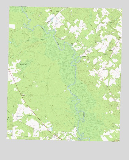
Abbeville North, GA USGS Topographic Map
Click on map above to begin viewing in our Map Viewer.

This topographic map contains these locations and features:
Feature Name Type Latitude Longitude GNIS ID View Map
Big BranchStreamN32.0824°W83.2971°311336View Map
Bowen CemeteryCemeteryN32.0966°W83.2518°311672View Map
Burnham BaySwampN32.0705°W83.3568°312053View Map
Cannonville CemeteryCemeteryN32.0229°W83.3690°345460View Map
Cannonville ChurchChurchN32.0227°W83.3682°354983View Map
Cedar CreekStreamN32.0952°W83.3321°312455View Map
County Line ChurchChurchN32.1210°W83.3188°313030View Map
Crooked CreekStreamN32.0055°W83.2785°313139View Map
Daniels MillpondReservoirN32.0952°W83.3184°313296View Map
Englewood ChurchChurchN32.0688°W83.2688°313949View Map
Folsom CreekStreamN32.0549°W83.3371°355862View Map
Free Gift ChurchChurchN32.1116°W83.2604°314361View Map
Gum CreekStreamN32.0624°W83.3540°314968View Map
Harrell PondReservoirN32.1135°W83.3271°341097View Map
Harrell Pond DamDamN32.1102°W83.3265°341096View Map
Little BranchStreamN32.0785°W83.2940°316960View Map
Manley Estate DamDamN32.0402°W83.2899°339563View Map
Manley Estate LakeReservoirN32.0402°W83.2899°339564View Map
Mitchell CemeteryCemeteryN32.0060°W83.3193°318338View Map
Mitchell Volunteer Fire DepartmentBuildingN32.0980°W83.2512°2604325View Map
New Daniels ChurchChurchN32.0860°W83.2596°319303View Map
Old Daniels ChurchChurchN32.0849°W83.2882°319966View Map
Phelps BluffCliffN32.0799°W83.2935°320426View Map
Poor Robin SpringSpringN32.0127°W83.2990°321009View Map
Rocky SpringSpringN32.0896°W83.3049°321862View Map
Sagegrass CreekStreamN32.0268°W83.3021°322041View Map
Springfield ChurchChurchN32.0421°W83.3590°323462View Map
Town CreekStreamN32.0021°W83.2968°324253View Map
UnionPopulated PlaceN32.0980°W83.2504°333299View Map
Wilcox County Public Boat RampLocaleN32.0007°W83.2957°1705322View Map

Note: Coordinates in the location and feature list above are referenced to NAD83 datum.


Copyright (C) 2008-2025 Ryan Niemi / Sunset Dynamics ... All Rights Reserved