TopoQuest Logo
Do you find TopoQuest useful?
Help keep TopoQuest running and adding new maps/features by donating!
Bitcoin:  19c7KJd3qBynnjoSw5npx9KScwjBe4ifkT
Litecoin:  LXs6TkuXGGXo1vDsWCkWVdjQX94eUKd6ui
Home View Maps Find Maps Find Places Resources & Links


Hawkinsville, Georgia Topographic Map

USGS Map Title: Hawkinsville, GA
USGS Map MRC: 32083C4
DRG (GeoTIFF) Download: o32083c4.tif


Neighboring USGS Topographic Map Quads:


  Hayneville, GA  
32083D5
 

  Westlake, GA  
32083D4
 

  Cochran, GA  
32083D3
 

  Klondike, GA  
32083C5
 

  Hawkinsville, GA  
32083C4
 

  Empire, GA  
32083C3
 

  Finleyson West, GA  
32083B5
 

  Finleyson East, GA  
32083B4
 

  West of Eastman, GA  
32083B3


Map MRC Location:

N33°
W84°
N33°
W83°
H8 H7 H6 H5 H4 H3 H2 H1
G8 G7 G6 G5 G4 G3 G2 G1
F8 F7 F6 F5 F4 F3 F2 F1
E8 E7 E6 E5 E4 E3 E2 E1
D8 D7 D6 D5 D4 D3 D2 D1
C8 C7 C6 C5 C4 C3 C2 C1
B8 B7 B6 B5 B4 B3 B2 B1
A8 A7 A6 A5 A4 A3 A2 A1
N32°
W84°
N32°
W83°

Hawkinsville, GA USGS 1:24K Topographic Map Preview:
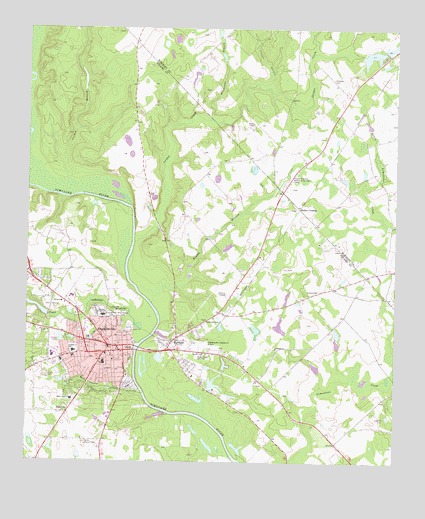
Hawkinsville, GA USGS Topographic Map
Click on map above to begin viewing in our Map Viewer.

This topographic map contains these locations and features:
Feature Name Type Latitude Longitude GNIS ID View Map
Adriel Primitive Baptist ChurchChurchN32.2829°W83.4788°347574View Map
Anderson Gift ChurchChurchN32.3140°W83.4932°334719View Map
Baker AcademySchoolN32.2682°W83.4843°310730View Map
Bembry LakeReservoirN32.2777°W83.4017°341122View Map
Bembry Lake DamDamN32.2768°W83.4016°341121View Map
Bozeman Junior High SchoolSchoolN32.2924°W83.4738°311696View Map
Carden BranchStreamN32.3315°W83.4863°312333View Map
Central High School (historical)SchoolN32.2813°W83.4324°334720View Map
Christ Temple (historical)ChurchN32.2729°W83.4699°347576View Map
Christian Hope Missionary Baptist ChurchChurchN32.2885°W83.4730°347577View Map
City of HawkinsvilleCivilN32.2966°W83.4830°2404665View Map
Collins BranchStreamN32.3582°W83.4179°312849View Map
Collins School (historical)SchoolN32.3746°W83.4268°342373View Map
Corinth ChurchChurchN32.2829°W83.4149°355311View Map
Double BranchStreamN32.3010°W83.4541°313558View Map
First Baptist ChurchChurchN32.2810°W83.4730°347580View Map
First Methodist ChurchChurchN32.2793°W83.4705°347581View Map
Free Providence ChurchChurchN32.3357°W83.4057°334614View Map
Harris DamDamN32.3685°W83.3782°340230View Map
Harris LakeReservoirN32.3694°W83.3775°340231View Map
HartfordPopulated PlaceN32.2857°W83.4491°356213View Map
Hartford Baptist ChurchChurchN32.2835°W83.4557°347583View Map
HawkinsvillePopulated PlaceN32.2838°W83.4721°331934View Map
Hawkinsville City HallBuildingN32.2821°W83.4682°347584View Map
Hawkinsville Fire DepartmentBuildingN32.2957°W83.4881°2603877View Map
Hawkinsville High SchoolSchoolN32.2807°W83.4910°347585View Map
Hawkinsville Police DepartmentBuildingN32.2845°W83.4678°2733919View Map
Hawkinsville Post OfficePost OfficeN32.2835°W83.4702°347586View Map
Hawkinsville State ParkParkN32.2707°W83.4627°347587View Map
Hawkinsville-Pulaski County AirportAirportN32.2837°W83.4429°326817View Map
Henderson BranchStreamN32.3499°W83.4377°315318View Map
Jordan CreekStreamN32.3135°W83.4635°316270View Map
Lizzie Bloomer ChurchChurchN32.3588°W83.4632°334721View Map
Lumpkin Street SchoolSchoolN32.2904°W83.4696°347588View Map
M E Roden LibraryBuildingN32.2832°W83.4721°347589View Map
Mile CreekStreamN32.2699°W83.4604°318151View Map
Mobley CrossingPopulated PlaceN32.3232°W83.4077°326401View Map
Mount Marriah ChurchChurchN32.2607°W83.4021°347590View Map
North Royce LakeReservoirN32.2874°W83.3945°341120View Map
North Royce Lake DamDamN32.2868°W83.3949°341119View Map
Orange Hill CemeteryCemeteryN32.2913°W83.4707°320090View Map
Pine Bloom CemeteryCemeteryN32.2929°W83.4668°320535View Map
Powers CemeteryCemeteryN32.2993°W83.4057°321121View Map
Prichards BluffCliffN32.3249°W83.4713°347592View Map
Pulaski County CourthouseBuildingN32.2829°W83.4691°347594View Map
Pulaski County FairgroundsParkN32.2721°W83.4649°347787View Map
Pulaski County JailBuildingN32.3006°W83.4685°347595View Map
Pulaski County Middle SchoolSchoolN32.2785°W83.4735°347596View Map
Pulaski County SchoolSchoolN32.2818°W83.4841°321218View Map
Pulaski County Sheriff's DepartmentBuildingN32.3004°W83.4681°2733827View Map
Pulaski Lookout TowerTowerN32.2554°W83.4802°344321View Map
Pulaski State PrisonBuildingN32.3118°W83.4561°2735751View Map
Pulaski-Bleckley Memorial GardensCemeteryN32.3335°W83.4102°351637View Map
Riverside Baptist ChurchChurchN32.2793°W83.4649°347598View Map
Roger H Lawson Memorial BridgeBridgeN32.2821°W83.4630°347599View Map
Saint Lukes Episcopal ChurchChurchN32.2816°W83.4699°347600View Map
Saint Philip Episcopal ChurchChurchN32.2891°W83.4730°347601View Map
Saint Thomas African Methodist Episcopal ChurchChurchN32.2863°W83.4710°347602View Map
Simpson CemeteryCemeteryN32.3604°W83.3966°323018View Map
Smith Chapel (historical)ChurchN32.3352°W83.4077°334618View Map
Smith DamDamN32.3668°W83.3849°336268View Map
Smith LakeReservoirN32.3682°W83.3826°336269View Map
South Royce LakeReservoirN32.2848°W83.3947°336198View Map
South Royce Lake DamDamN32.2835°W83.3949°336197View Map
Suzies LakeReservoirN32.2722°W83.4362°336200View Map
Suzies Lake DamDamN32.2718°W83.4382°336199View Map
Taylor Regional HospitalHospitalN32.2979°W83.4850°347597View Map
Taylors BluffCliffN32.3263°W83.4646°347603View Map
TippettsPopulated PlaceN32.2643°W83.4863°333237View Map
Tippetts Pine Level ChurchChurchN32.2566°W83.4810°334722View Map
Town CreekStreamN32.2924°W83.4627°324254View Map
Town Creek Country ClubLocaleN32.2949°W83.4916°347604View Map
Town Creek Country Club LakeReservoirN32.2941°W83.4956°336190View Map
Town Creek Country Club Lake DamDamN32.2918°W83.4932°336189View Map
WCEH-AM (Hawkinsville)TowerN32.2807°W83.4435°352462View Map
WCEH-FM (Hawkinsville)TowerN32.2807°W83.4418°352705View Map

Note: Coordinates in the location and feature list above are referenced to NAD83 datum.


Copyright (C) 2008-2025 Ryan Niemi / Sunset Dynamics ... All Rights Reserved