TopoQuest Logo
Do you find TopoQuest useful?
Help keep TopoQuest running and adding new maps/features by donating!
Bitcoin:  19c7KJd3qBynnjoSw5npx9KScwjBe4ifkT
Litecoin:  LXs6TkuXGGXo1vDsWCkWVdjQX94eUKd6ui
Home View Maps Find Maps Find Places Resources & Links


Fordsville, Kentucky Topographic Map

USGS Map Title: Fordsville, KY
USGS Map MRC: 37086F6
DRG (GeoTIFF) Download: o37086f6.tif


Neighboring USGS Topographic Map Quads:


  Pellville, KY  
37086G7
 

  Cloverport, KY  
37086G6
 

  Mattingly, KY  
37086G5
 

  Whitesville, KY  
37086F7
 

  Fordsville, KY  
37086F6
 

  Glen Dean, KY  
37086F5
 

  Dundee, KY  
37086E7
 

  Olaton, KY  
37086E6
 

  Falls of Rough, KY  
37086E5


Map MRC Location:

N38°
W87°
N38°
W86°
H8 H7 H6 H5 H4 H3 H2 H1
G8 G7 G6 G5 G4 G3 G2 G1
F8 F7 F6 F5 F4 F3 F2 F1
E8 E7 E6 E5 E4 E3 E2 E1
D8 D7 D6 D5 D4 D3 D2 D1
C8 C7 C6 C5 C4 C3 C2 C1
B8 B7 B6 B5 B4 B3 B2 B1
A8 A7 A6 A5 A4 A3 A2 A1
N37°
W87°
N37°
W86°

Fordsville, KY USGS 1:24K Topographic Map Preview:
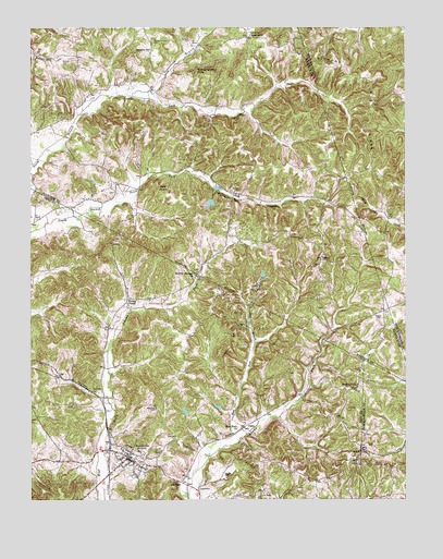
Fordsville, KY USGS Topographic Map
Click on map above to begin viewing in our Map Viewer.

This topographic map contains these locations and features:
Feature Name Type Latitude Longitude GNIS ID View Map
AskinPopulated PlaceN37.6384°W86.6400°486107View Map
Bald KnobSummitN37.7067°W86.7055°486275View Map
Beatty CemeteryCemeteryN37.6739°W86.6341°486597View Map
Boling Chapel CemeteryCemeteryN37.7464°W86.7091°487642View Map
CabotPopulated PlaceN37.6887°W86.6533°507634View Map
City of FordsvilleCivilN37.6357°W86.7171°2403629View Map
Dry BranchStreamN37.6666°W86.6754°491148View Map
East Fork Adams ForkStreamN37.6406°W86.6808°491434View Map
East Fork ChurchChurchN37.6439°W86.6808°491446View Map
EastonPopulated PlaceN37.7062°W86.6817°491519View Map
EllmitchPopulated PlaceN37.6295°W86.6997°507931View Map
FordsvillePopulated PlaceN37.6362°W86.7175°492316View Map
Fordsville Fire DepartmentBuildingN37.6377°W86.7203°2637057View Map
Fox BranchStreamN37.7280°W86.6786°2743745View Map
Haynes CemeteryCemeteryN37.6320°W86.6861°493920View Map
Hickory Lick RidgeRidgeN37.7312°W86.6364°494140View Map
Hopewell ChurchChurchN37.6553°W86.6405°494531View Map
Line BranchStreamN37.6756°W86.7161°496580View Map
Newton Springs Baptist ChurchChurchN37.6850°W86.6952°499456View Map
Richards Branch South ForkStreamN37.7066°W86.7183°2743747View Map
SandersPopulated PlaceN37.7436°W86.7099°2743749View Map
Sanders CemeteryCemeteryN37.7467°W86.6969°502950View Map
Sanders SchoolSchoolN37.7437°W86.7100°502952View Map
Sugarcamp BranchStreamN37.7320°W86.7164°504691View Map
Turkey Scratch KnobSummitN37.7395°W86.6900°505635View Map
Victoria BranchStreamN37.7334°W86.6695°2743757View Map
Victoria CrossroadsPopulated PlaceN37.7478°W86.6778°509288View Map
Wedding CemeteryCemeteryN37.6492°W86.7080°506348View Map
Wesley ChapelChurchN37.6767°W86.7172°506395View Map

Note: Coordinates in the location and feature list above are referenced to NAD83 datum.


Copyright (C) 2008-2024 Ryan Niemi / Sunset Dynamics ... All Rights Reserved