TopoQuest Logo
Do you find TopoQuest useful?
Help keep TopoQuest running and adding new maps/features by donating!
Bitcoin:  19c7KJd3qBynnjoSw5npx9KScwjBe4ifkT
Litecoin:  LXs6TkuXGGXo1vDsWCkWVdjQX94eUKd6ui
Home View Maps Find Maps Find Places Resources & Links


Glen Dean, Kentucky Topographic Map

USGS Map Title: Glen Dean, KY
USGS Map MRC: 37086F5
DRG (GeoTIFF) Download: o37086f5.tif


Neighboring USGS Topographic Map Quads:


  Cloverport, KY  
37086G6
 

  Mattingly, KY  
37086G5
 

  Hardinsburg, KY  
37086G4
 

  Fordsville, KY  
37086F6
 

  Glen Dean, KY  
37086F5
 

  Kingswood, KY  
37086F4
 

  Olaton, KY  
37086E6
 

  Falls of Rough, KY  
37086E5
 

  McDaniels, KY  
37086E4


Map MRC Location:

N38°
W87°
N38°
W86°
H8 H7 H6 H5 H4 H3 H2 H1
G8 G7 G6 G5 G4 G3 G2 G1
F8 F7 F6 F5 F4 F3 F2 F1
E8 E7 E6 E5 E4 E3 E2 E1
D8 D7 D6 D5 D4 D3 D2 D1
C8 C7 C6 C5 C4 C3 C2 C1
B8 B7 B6 B5 B4 B3 B2 B1
A8 A7 A6 A5 A4 A3 A2 A1
N37°
W87°
N37°
W86°

Glen Dean, KY USGS 1:24K Topographic Map Preview:
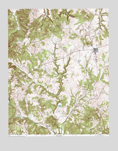
Glen Dean, KY USGS Topographic Map
Click on map above to begin viewing in our Map Viewer.

This topographic map contains these locations and features:
Feature Name Type Latitude Longitude GNIS ID View Map
Black Jack KnobSummitN37.6342°W86.5675°487368View Map
Black Lick Baptist ChurchChurchN37.6651°W86.5880°487374View Map
Black Lick CreekStreamN37.6626°W86.5653°487377View Map
Cretcheloe HillSummitN37.6406°W86.5272°490338View Map
Daniels CreekStreamN37.6406°W86.5528°490575View Map
DempsterPopulated PlaceN37.6253°W86.5597°507845View Map
Dry ForkStreamN37.6842°W86.5619°491200View Map
Egypt KnobSummitN37.6912°W86.6178°491592View Map
Glen DeanPopulated PlaceN37.6534°W86.5411°492886View Map
Glen Dean-Vanzant DivisionCivilN37.6496°W86.5405°1936888View Map
Knob Lick HillSummitN37.7442°W86.5305°495845View Map
McQuadyPopulated PlaceN37.7084°W86.5189°497945View Map
McQuady Fire DepartmentBuildingN37.7086°W86.5159°2636709View Map
Owens CemeteryCemeteryN37.6256°W86.5347°500066View Map
Powell HillSummitN37.6456°W86.5130°501246View Map
RockvalePopulated PlaceN37.6326°W86.5766°508960View Map
Saint Marys of the Woods SchoolSchoolN37.7117°W86.5205°502695View Map
Tar ForkPopulated PlaceN37.7206°W86.6016°509186View Map
Tar Fork ChurchChurchN37.7462°W86.5966°504954View Map
VanzantPopulated PlaceN37.6431°W86.6125°509275View Map

Note: Coordinates in the location and feature list above are referenced to NAD83 datum.


Copyright (C) 2008-2025 Ryan Niemi / Sunset Dynamics ... All Rights Reserved