TopoQuest Logo
Do you find TopoQuest useful?
Help keep TopoQuest running and adding new maps/features by donating!
Bitcoin:  19c7KJd3qBynnjoSw5npx9KScwjBe4ifkT
Litecoin:  LXs6TkuXGGXo1vDsWCkWVdjQX94eUKd6ui
Home View Maps Find Maps Find Places Resources & Links


Fort Adams, Mississippi Topographic Map

USGS Map Title: Fort Adams, MS
USGS Map MRC: 31091A5
DRG (GeoTIFF) Download: o31091a5.tif


Neighboring USGS Topographic Map Quads:


  Lower Sunk Lake, LA  
31091B6
 

  Lake Mary, MS  
31091B5
 

  Lessley, MS  
31091B4
 

  Turnbull Island, LA  
31091A6
 

  Fort Adams, MS  
31091A5
 

  Pinckneyville, MS  
31091A4
 

  Innis, LA  
30091H6
 

  Angola, LA  
30091H5
 

  Weyanoke, LA  
30091H4


Map MRC Location:

N32°
W92°
N32°
W91°
H8 H7 H6 H5 H4 H3 H2 H1
G8 G7 G6 G5 G4 G3 G2 G1
F8 F7 F6 F5 F4 F3 F2 F1
E8 E7 E6 E5 E4 E3 E2 E1
D8 D7 D6 D5 D4 D3 D2 D1
C8 C7 C6 C5 C4 C3 C2 C1
B8 B7 B6 B5 B4 B3 B2 B1
A8 A7 A6 A5 A4 A3 A2 A1
N31°
W92°
N31°
W91°

Fort Adams, MS USGS 1:24K Topographic Map Preview:
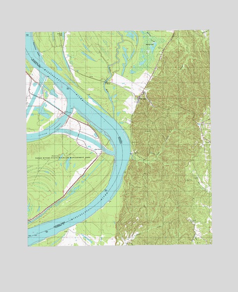
Fort Adams, MS USGS Topographic Map
Click on map above to begin viewing in our Map Viewer.

This topographic map contains these locations and features:
Feature Name Type Latitude Longitude GNIS ID View Map
Arcole Plantation (historical)LocaleN31.0224°W91.5126°686145View Map
Belmont LakeLakeN31.1145°W91.5391°666811View Map
Belmont Lake Oil FieldOilfieldN31.1149°W91.5354°691043View Map
Blockhouse HillSummitN31.0802°W91.5479°686150View Map
Buffalo RiverStreamN31.0735°W91.5657°692757View Map
Clark CreekStreamN31.0538°W91.5551°668512View Map
Clarksville CemeteryCemeteryN31.0602°W91.5540°668526View Map
Cochie Oil FieldOilfieldN31.0874°W91.6235°544624View Map
Coochie (historical)Populated PlaceN31.0955°W91.6223°544623View Map
Fort AdamsPopulated PlaceN31.0866°W91.5482°670108View Map
Fort Adams BarBarN31.0730°W91.5710°712197View Map
Fort Adams LandingLocaleN31.0638°W91.5568°686154View Map
Fort Adams Oil FieldOilfieldN31.0613°W91.5535°691024View Map
Fort Adams ReachChannelN31.0168°W91.5918°686155View Map
Fort Adams Reach RevetmentLeveeN31.0121°W91.5940°686156View Map
Glendale PlantationLocaleN31.0502°W91.5821°544640View Map
Hunter Hall Plantation (historical)LocaleN31.0168°W91.5132°686159View Map
Knox CemeteryCemeteryN31.0754°W91.5879°549534View Map
Knox Church (historical)ChurchN31.0752°W91.5876°549535View Map
Knox LandingLocaleN31.0791°W91.5887°544644View Map
Knox Plantation (historical)LocaleN31.0788°W91.5960°549536View Map
Knox School (historical)SchoolN31.0752°W91.5876°549537View Map
Linwood CemeteryCemeteryN31.0129°W91.5137°672519View Map
Linwood Plantation (historical)LocaleN31.0113°W91.5112°686161View Map
Lum LandingLocaleN31.0188°W91.5979°544650View Map
Lum Point PlantationLocaleN31.0377°W91.5971°544651View Map
Mess Ridge CemeteryCemeteryN31.0368°W91.5171°673503View Map
Mount Olive Church (historical)ChurchN31.0032°W91.6015°686166View Map
Mount Olive School (historical)SchoolN31.0035°W91.6015°686167View Map
Mount Ricca School (historical)SchoolN31.0327°W91.5454°686169View Map
North Fort Adams Oil FieldOilfieldN31.1030°W91.5362°691027View Map
Old River Control StructureLocaleN31.0782°W91.5996°558808View Map
Old River Ctl Auxillary Structure HeliportAirportN31.0602°W91.6037°1632839View Map
Palmetto PointCapeN31.1130°W91.6182°675418View Map
Pickneyville Oil FieldOilfieldN31.0391°W91.5112°691030View Map
Point BreezeCapeN31.0627°W91.5682°549603View Map
Point BreezePopulated PlaceN31.0549°W91.5737°541165View Map
Point Breeze Church (historical)ChurchN31.0627°W91.5687°549542View Map
Point Breeze PlantationLocaleN31.0618°W91.5918°544662View Map
Point Breeze RevetmentLeveeN31.0705°W91.5782°549543View Map
PondLocaleN31.0707°W91.5062°676192View Map
Pond Oil FieldOilfieldN31.0707°W91.5023°691032View Map
Prairie LakeLakeN31.0523°W91.6016°555721View Map
Riverside CemeteryCemeteryN31.0599°W91.5540°676679View Map
Rock HillSummitN31.0363°W91.5551°686153View Map
Saint Joseph CemeteryCemeteryN31.0829°W91.5482°686173View Map
Saint Joseph ChurchChurchN31.0841°W91.5485°686174View Map
South Bank RevetmentLeveeN31.0630°W91.6168°549549View Map
Stamps LandingLocaleN31.0891°W91.5851°686179View Map
Stamps Oil FieldOilfieldN31.1168°W91.6004°691034View Map
Stamps Plantation (historical)LocaleN31.1043°W91.5946°686180View Map
Tarbert Plantation (historical)LocaleN31.0085°W91.5973°686182View Map
Tarberts LandingLocaleN31.0127°W91.5923°686181View Map
Three Rivers State Wildlife Management AreaParkN31.0491°W91.6001°1966041View Map
White Vine PlantationLocaleN31.0852°W91.6140°544701View Map
Zion Hill Church (historical)ChurchN31.0916°W91.5443°686186View Map

Note: Coordinates in the location and feature list above are referenced to NAD83 datum.


Copyright (C) 2008-2025 Ryan Niemi / Sunset Dynamics ... All Rights Reserved