TopoQuest Logo
Do you find TopoQuest useful?
Help keep TopoQuest running and adding new maps/features by donating!
Bitcoin:  19c7KJd3qBynnjoSw5npx9KScwjBe4ifkT
Litecoin:  LXs6TkuXGGXo1vDsWCkWVdjQX94eUKd6ui
Home View Maps Find Maps Find Places Resources & Links


Arvonia, Virginia Topographic Map

USGS Map Title: Arvonia, VA
USGS Map MRC: 37078F3
DRG (GeoTIFF) Download: o37078f3.tif


Neighboring USGS Topographic Map Quads:


  Scottsville, VA  
37078G4
 

  Palmyra, VA  
37078G3
 

  Columbia, VA  
37078G2
 

  Diana Mills, VA  
37078F4
 

  Arvonia, VA  
37078F3
 

  Lakeside Village, VA  
37078F2
 

  Dillwyn, VA  
37078E4
 

  Gold Hill, VA  
37078E3
 

  Whiteville, VA  
37078E2


Map MRC Location:

N38°
W79°
N38°
W78°
H8 H7 H6 H5 H4 H3 H2 H1
G8 G7 G6 G5 G4 G3 G2 G1
F8 F7 F6 F5 F4 F3 F2 F1
E8 E7 E6 E5 E4 E3 E2 E1
D8 D7 D6 D5 D4 D3 D2 D1
C8 C7 C6 C5 C4 C3 C2 C1
B8 B7 B6 B5 B4 B3 B2 B1
A8 A7 A6 A5 A4 A3 A2 A1
N37°
W79°
N37°
W78°

Arvonia, VA USGS 1:24K Topographic Map Preview:
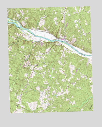
Arvonia, VA USGS Topographic Map
Click on map above to begin viewing in our Map Viewer.

This topographic map contains these locations and features:
Feature Name Type Latitude Longitude GNIS ID View Map
Anderson DamDamN37.6451°W78.3064°1489293View Map
Arvon ChurchChurchN37.6921°W78.3492°1462570View Map
Arvon Presbyterian ChurchChurchN37.6846°W78.3431°1462538View Map
ArvoniaPopulated PlaceN37.6835°W78.3414°1462571View Map
Arvonia Methodist ChurchChurchN37.6811°W78.3410°2560362View Map
Arvonia Post OfficePost OfficeN37.6810°W78.3377°2562182View Map
Arvonia QuarryMineN37.6975°W78.3492°2633258View Map
Arvonia Volunteer Fire DepartmentBuildingN37.6810°W78.3428°2086357View Map
Bear Garden CreekStreamN37.7085°W78.2942°1462890View Map
Bettie CemeteryCemeteryN37.7037°W78.3553°1463256View Map
Big IslandIslandN37.7349°W78.3700°1463365View Map
Bowler CemeteryCemeteryN37.7390°W78.2906°1494053View Map
Bremo BluffPopulated PlaceN37.7124°W78.2975°1492625View Map
Bremo Bluff Post OfficePost OfficeN37.7123°W78.2969°2766344View Map
Bremo CreekStreamN37.7254°W78.3453°1463788View Map
Bremo MansionBuildingN37.7254°W78.3297°1463789View Map
Bremo Power StationBuildingN37.7090°W78.2878°1494054View Map
BridgeportPopulated PlaceN37.7099°W78.3339°1477140View Map
Buckingham County Volunteer Rescue Squad Station 17BuildingN37.6810°W78.3428°2562202View Map
Calvary Christian SchoolSchoolN37.7030°W78.3094°2499253View Map
Campbell CornerPopulated PlaceN37.6596°W78.2847°1492701View Map
Chestnut Grove ChurchChurchN37.6901°W78.3706°1464817View Map
Chestnut Grove School (historical)SchoolN37.6949°W78.3622°1501514View Map
Cleveland IslandIslandN37.7229°W78.3453°1464979View Map
Cocke CreekStreamN37.7163°W78.3306°1465037View Map
Cole CreekStreamN37.6907°W78.2519°1465076View Map
Cottonpatch BranchStreamN37.6499°W78.3264°1465278View Map
District 1CivilN37.6612°W78.3251°2390679View Map
F. U. M. A. Airport (historical)AirportN37.7446°W78.2703°1480225View Map
GilliamsvillePopulated PlaceN37.6676°W78.2600°1477350View Map
Gold Hill Elementary SchoolSchoolN37.6343°W78.3637°1464504View Map
Grace CemeteryCemeteryN37.7165°W78.2972°1494065View Map
Grace Memorial Episcopal ChurchChurchN37.7168°W78.2972°1494066View Map
Highway Mission ChurchChurchN37.6588°W78.3492°1468041View Map
Holman CreekStreamN37.7090°W78.2900°1468169View Map
Hunts CreekStreamN37.7104°W78.3375°1468409View Map
John H Cocke Memorial BridgeBridgeN37.7118°W78.3019°1491176View Map
Lake TahoeReservoirN37.6844°W78.3218°1475435View Map
LeSueurPopulated PlaceN37.6829°W78.3542°1493185View Map
Liberty ChurchChurchN37.6893°W78.2917°1469366View Map
Liberty School (historical)SchoolN37.6690°W78.2897°1501553View Map
Lower Bremo MansionBuildingN37.7240°W78.3153°1469908View Map
McIver DamDamN37.7285°W78.2881°1489782View Map
McIver LakeReservoirN37.7287°W78.2860°1489783View Map
Mount Zion ChurchChurchN37.6593°W78.2792°1471138View Map
New Ash DamDamN37.7101°W78.2897°1489791View Map
New Ash PondReservoirN37.7101°W78.2897°1489792View Map
New CantonPopulated PlaceN37.7051°W78.2994°1493341View Map
New Canton Post OfficePost OfficeN37.7056°W78.3002°2560882View Map
O'Brien CemeteryCemeteryN37.7479°W78.2558°1494076View Map
Oak Grove ChurchChurchN37.6476°W78.3194°1471727View Map
Oak Hill CemeteryCemeteryN37.7071°W78.2533°1471750View Map
Obrien DamDamN37.7151°W78.2797°1489787View Map
Obrien PondReservoirN37.7151°W78.2797°1489788View Map
PenlanPopulated PlaceN37.6638°W78.3672°1493413View Map
Proffitt CemeteryCemeteryN37.7437°W78.3744°1494080View Map
Richmond - Arvonia QuarryMineN37.6911°W78.3461°2633257View Map
Seay ChapelChurchN37.7449°W78.3611°1474132View Map
ShoresLocaleN37.7346°W78.3597°1474550View Map
Slate RiverStreamN37.7140°W78.3253°1474674View Map
Solite Corporation DamDamN37.7101°W78.3231°1489304View Map
StrathousePopulated PlaceN37.7238°W78.3319°1493663View Map
Sutherland DamDamN37.6751°W78.2864°1489288View Map
Sutherland PondReservoirN37.6751°W78.2864°1489289View Map
Trinity Presbyterian ChurchChurchN37.7053°W78.3039°2560462View Map
Trinity Presbyterian Church CemeteryCemeteryN37.7053°W78.3042°2562022View Map
Turner DamDamN37.6318°W78.3581°1489294View Map
Wesleyan ChurchChurchN37.6465°W78.3578°1476468View Map
West BottomPopulated PlaceN37.7171°W78.2608°1493772View Map
West Bottom Baptist ChurchChurchN37.7176°W78.2606°1494088View Map
Zion Grove ChurchChurchN37.6979°W78.3144°1474411View Map

Note: Coordinates in the location and feature list above are referenced to NAD83 datum.


Copyright (C) 2008-2024 Ryan Niemi / Sunset Dynamics ... All Rights Reserved