TopoQuest Logo
Do you find TopoQuest useful?
Help keep TopoQuest running and adding new maps/features by donating!
Bitcoin:  19c7KJd3qBynnjoSw5npx9KScwjBe4ifkT
Litecoin:  LXs6TkuXGGXo1vDsWCkWVdjQX94eUKd6ui
Home View Maps Find Maps Find Places Resources & Links


Diana Mills, Virginia Topographic Map

USGS Map Title: Diana Mills, VA
USGS Map MRC: 37078F4
DRG (GeoTIFF) Download: o37078f4.tif


Neighboring USGS Topographic Map Quads:


  Esmont, VA  
37078G5
 

  Scottsville, VA  
37078G4
 

  Palmyra, VA  
37078G3
 

  Glenmore, VA  
37078F5
 

  Diana Mills, VA  
37078F4
 

  Arvonia, VA  
37078F3
 

  Buckingham, VA  
37078E5
 

  Dillwyn, VA  
37078E4
 

  Gold Hill, VA  
37078E3


Map MRC Location:

N38°
W79°
N38°
W78°
H8 H7 H6 H5 H4 H3 H2 H1
G8 G7 G6 G5 G4 G3 G2 G1
F8 F7 F6 F5 F4 F3 F2 F1
E8 E7 E6 E5 E4 E3 E2 E1
D8 D7 D6 D5 D4 D3 D2 D1
C8 C7 C6 C5 C4 C3 C2 C1
B8 B7 B6 B5 B4 B3 B2 B1
A8 A7 A6 A5 A4 A3 A2 A1
N37°
W79°
N37°
W78°

Diana Mills, VA USGS 1:24K Topographic Map Preview:
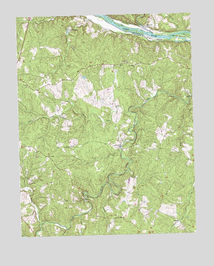
Diana Mills, VA USGS Topographic Map
Click on map above to begin viewing in our Map Viewer.

This topographic map contains these locations and features:
Feature Name Type Latitude Longitude GNIS ID View Map
Crooked CreekStreamN37.6496°W78.4344°1465463View Map
Diana MillsLocaleN37.6751°W78.4272°1465758View Map
Diana Mills Post Office (historical)Post OfficeN37.6896°W78.4450°1501519View Map
Diana Mills School (historical)SchoolN37.6732°W78.4014°1501520View Map
District 6CivilN37.6746°W78.4946°2390688View Map
District 6, Slate River (historical)CivilN37.6821°W78.4895°1927501View Map
Dry CreekStreamN37.6740°W78.4269°1465985View Map
Green CreekStreamN37.6613°W78.4217°1467465View Map
Gregory IslandIslandN37.7357°W78.4014°1467535View Map
Hale CemeteryCemeteryN37.6624°W78.4938°1501540View Map
HardwarePopulated PlaceN37.7429°W78.4056°1477395View Map
Hardware RiverStreamN37.7390°W78.4028°1467736View Map
Holman School (historical)SchoolN37.6843°W78.4292°1501544View Map
Joshua CreekStreamN37.6365°W78.4586°1468883View Map
Little George CreekStreamN37.7401°W78.4203°1469552View Map
Martin DamDamN37.6568°W78.4197°1489297View Map
Mount Tabor ChurchChurchN37.7210°W78.4261°1471079View Map
Mount Tabor School (historical)SchoolN37.7215°W78.4311°1501564View Map
Muddy CreekStreamN37.6326°W78.4856°1471228View Map
Paynes MillPopulated PlaceN37.7421°W78.4614°1493404View Map
Randolph School (historical)SchoolN37.7140°W78.3789°1501584View Map
Ridgeway ChurchChurchN37.7110°W78.4928°1473211View Map
Rockfish CreekStreamN37.7393°W78.3844°1473405View Map
Rocky CreekStreamN37.6982°W78.3789°1473450View Map
Seven IslandsIslandN37.7374°W78.3839°1474174View Map
Sharon ChurchChurchN37.6729°W78.4886°1474444View Map
Sharps CreekStreamN37.6940°W78.4183°1474454View Map
Slate HillPopulated PlaceN37.6321°W78.3869°1493607View Map
Spreading Oak ChurchChurchN37.6751°W78.4628°1474969View Map
Stouts CreekStreamN37.6454°W78.4542°1475227View Map
Sunny SidePopulated PlaceN37.6349°W78.4275°1477793View Map
TaggartPopulated PlaceN37.7229°W78.4214°1477804View Map
Turpin CreekStreamN37.6293°W78.4675°1475992View Map
Union Branch ChurchChurchN37.7207°W78.4153°1476026View Map
Union Branch School (historical)SchoolN37.7221°W78.4106°1501611View Map
Well WaterLocaleN37.6707°W78.4803°1476441View Map

Note: Coordinates in the location and feature list above are referenced to NAD83 datum.


Copyright (C) 2008-2025 Ryan Niemi / Sunset Dynamics ... All Rights Reserved