TopoQuest Logo
Do you find TopoQuest useful?
Help keep TopoQuest running and adding new maps/features by donating!
Bitcoin:  19c7KJd3qBynnjoSw5npx9KScwjBe4ifkT
Litecoin:  LXs6TkuXGGXo1vDsWCkWVdjQX94eUKd6ui
Home View Maps Find Maps Find Places Resources & Links


Fortuna, Missouri Topographic Map

USGS Map Title: Fortuna, MO
USGS Map MRC: 38092E7
DRG (GeoTIFF) Download: o38092e7.tif


Neighboring USGS Topographic Map Quads:


  Otterville East, MO  
38092F8
 

  Tipton, MO  
38092F7
 

  Clarksburg, MO  
38092F6
 

  Florence, MO  
38092E8
 

  Fortuna, MO  
38092E7
 

  Latham, MO  
38092E6
 

  Stover, MO  
38092D8
 

  Versailles, MO  
38092D7
 

  Barnett, MO  
38092D6


Map MRC Location:

N39°
W93°
N39°
W92°
H8 H7 H6 H5 H4 H3 H2 H1
G8 G7 G6 G5 G4 G3 G2 G1
F8 F7 F6 F5 F4 F3 F2 F1
E8 E7 E6 E5 E4 E3 E2 E1
D8 D7 D6 D5 D4 D3 D2 D1
C8 C7 C6 C5 C4 C3 C2 C1
B8 B7 B6 B5 B4 B3 B2 B1
A8 A7 A6 A5 A4 A3 A2 A1
N38°
W93°
N38°
W92°

Fortuna, MO USGS 1:24K Topographic Map Preview:
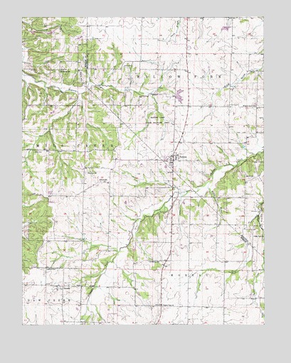
Fortuna, MO USGS Topographic Map
Click on map above to begin viewing in our Map Viewer.

This topographic map contains these locations and features:
Feature Name Type Latitude Longitude GNIS ID View Map
AikinsvillePopulated PlaceN38.5581°W92.8363°740617View Map
Aikinsville CemeteryCemeteryN38.5614°W92.8430°713174View Map
Allison CemeteryCemeteryN38.5700°W92.8691°713238View Map
Alvin (historical)LocaleN38.5111°W92.7577°744782View Map
Becker School (historical)SchoolN38.5939°W92.8057°743615View Map
Centennial SchoolSchoolN38.6034°W92.8558°729716View Map
Crews Lake DamDamN38.5934°W92.7969°763910View Map
FortunaPopulated PlaceN38.5667°W92.7980°718113View Map
Fortuna Fire Protection District Fortuna StationBuildingN38.5702°W92.7959°2620333View Map
Fortuna Post OfficePost OfficeN38.5689°W92.7964°2782867View Map
GlenstedPopulated PlaceN38.5156°W92.8555°718519View Map
Glensted CemeteryCemeteryN38.5155°W92.8536°2702555View Map
Glensted SchoolSchoolN38.5228°W92.8580°718520View Map
Glensted United Methodist ChurchChurchN38.5154°W92.8545°2702556View Map
Hickory Grove School (historical)SchoolN38.5886°W92.7541°719473View Map
Knipp Lake DamDamN38.6217°W92.7685°763911View Map
Liberty CemeteryCemeteryN38.6045°W92.8235°720961View Map
Newkirk CemeteryCemeteryN38.5595°W92.7555°723335View Map
Prairie View ChurchChurchN38.5078°W92.8030°724892View Map
Reno HillSummitN38.6006°W92.8463°725218View Map
Saint Martins SchoolSchoolN38.5256°W92.8102°729810View Map
Short ForkStreamN38.6231°W92.7510°755626View Map
Stone CemeteryCemeteryN38.6039°W92.8560°727130View Map
Township of Willow ForkCivilN38.6220°W92.7814°767036View Map
West View School (historical)SchoolN38.5359°W92.7555°728639View Map
Willow BranchStreamN38.5575°W92.7785°728921View Map

Note: Coordinates in the location and feature list above are referenced to NAD83 datum.


Copyright (C) 2008-2025 Ryan Niemi / Sunset Dynamics ... All Rights Reserved