TopoQuest Logo
Do you find TopoQuest useful?
Help keep TopoQuest running and adding new maps/features by donating!
Bitcoin:  19c7KJd3qBynnjoSw5npx9KScwjBe4ifkT
Litecoin:  LXs6TkuXGGXo1vDsWCkWVdjQX94eUKd6ui
Home View Maps Find Maps Find Places Resources & Links


Latham, Missouri Topographic Map

USGS Map Title: Latham, MO
USGS Map MRC: 38092E6
DRG (GeoTIFF) Download: o38092e6.tif


Neighboring USGS Topographic Map Quads:


  Tipton, MO  
38092F7
 

  Clarksburg, MO  
38092F6
 

  California North, MO  
38092F5
 

  Fortuna, MO  
38092E7
 

  Latham, MO  
38092E6
 

  California South, MO  
38092E5
 

  Versailles, MO  
38092D7
 

  Barnett, MO  
38092D6
 

  Olean, MO  
38092D5


Map MRC Location:

N39°
W93°
N39°
W92°
H8 H7 H6 H5 H4 H3 H2 H1
G8 G7 G6 G5 G4 G3 G2 G1
F8 F7 F6 F5 F4 F3 F2 F1
E8 E7 E6 E5 E4 E3 E2 E1
D8 D7 D6 D5 D4 D3 D2 D1
C8 C7 C6 C5 C4 C3 C2 C1
B8 B7 B6 B5 B4 B3 B2 B1
A8 A7 A6 A5 A4 A3 A2 A1
N38°
W93°
N38°
W92°

Latham, MO USGS 1:24K Topographic Map Preview:
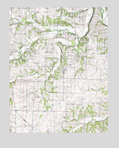
Latham, MO USGS Topographic Map
Click on map above to begin viewing in our Map Viewer.

This topographic map contains these locations and features:
Feature Name Type Latitude Longitude GNIS ID View Map
Bethel ChurchChurchN38.5222°W92.7424°714058View Map
Elliott Lake DamDamN38.5084°W92.6319°763791View Map
Fortuna Fire Protection District LathamBuildingN38.5601°W92.6817°2620507View Map
Green Grove ChurchChurchN38.5784°W92.7180°718790View Map
Green Grove School (historical)SchoolN38.5694°W92.7149°718793View Map
Hazel Dell School (historical)SchoolN38.5356°W92.7174°719283View Map
Highland CemeteryCemeteryN38.5400°W92.7005°719561View Map
Independence School (historical)SchoolN38.6225°W92.6702°743628View Map
Kelley BranchStreamN38.6109°W92.7360°720503View Map
LathamPopulated PlaceN38.5609°W92.6824°755554View Map
Latham CemeteryCemeteryN38.5645°W92.6682°720825View Map
Latham Elementary SchoolSchoolN38.5592°W92.6801°2571123View Map
Latham Post OfficePost OfficeN38.5607°W92.6813°2782759View Map
Lick CreekStreamN38.5600°W92.6994°729330View Map
Lone Oak School (historical)SchoolN38.5667°W92.6441°743631View Map
Moreau CemeteryCemeteryN38.6242°W92.7338°722597View Map
Oak Dale School (historical)SchoolN38.5920°W92.7090°723557View Map
Pilot BranchStreamN38.5875°W92.6638°729366View Map
Pilot Grove ChurchChurchN38.5756°W92.6585°724347View Map
Pilot School (historical)SchoolN38.5961°W92.6394°724355View Map
Pleasant Hill School (historical)SchoolN38.5334°W92.6591°724548View Map
Pleasant View School (historical)SchoolN38.6206°W92.7077°743637View Map
Porter Lake DamDamN38.5017°W92.6635°763914View Map
R Elliott LakeReservoirN38.5084°W92.6319°763792View Map
Smith CreekStreamN38.5942°W92.6641°726611View Map
Straight ForkStreamN38.6022°W92.6944°727170View Map
Township of Pilot GroveCivilN38.5494°W92.6487°767034View Map
Turkey Trot CreekStreamN38.5445°W92.7110°727882View Map
Willow ForkStreamN38.6022°W92.6944°729413View Map
Zimmerman Lake DamDamN38.5150°W92.6785°762253View Map

Note: Coordinates in the location and feature list above are referenced to NAD83 datum.


Copyright (C) 2008-2025 Ryan Niemi / Sunset Dynamics ... All Rights Reserved