TopoQuest Logo
Do you find TopoQuest useful?
Help keep TopoQuest running and adding new maps/features by donating!
Bitcoin:  19c7KJd3qBynnjoSw5npx9KScwjBe4ifkT
Litecoin:  LXs6TkuXGGXo1vDsWCkWVdjQX94eUKd6ui
Home View Maps Find Maps Find Places Resources & Links


Foules, Louisiana Topographic Map

USGS Map Title: Foules, LA
USGS Map MRC: 31091G5
DRG (GeoTIFF) Download: o31091g5.tif


Neighboring USGS Topographic Map Quads:


  Wisner, LA  
31091H6
 

  Oakley, LA  
31091H5
 

  Gretna Green, LA  
31091H4
 

  Sicily Island, LA  
31091G6
 

  Foules, LA  
31091G5
 

  Waterproof, LA  
31091G4
 

  Dunbarton, LA  
31091F6
 

  Ferriday North, LA  
31091F5
 

  Spokane, LA  
31091F4


Map MRC Location:

N32°
W92°
N32°
W91°
H8 H7 H6 H5 H4 H3 H2 H1
G8 G7 G6 G5 G4 G3 G2 G1
F8 F7 F6 F5 F4 F3 F2 F1
E8 E7 E6 E5 E4 E3 E2 E1
D8 D7 D6 D5 D4 D3 D2 D1
C8 C7 C6 C5 C4 C3 C2 C1
B8 B7 B6 B5 B4 B3 B2 B1
A8 A7 A6 A5 A4 A3 A2 A1
N31°
W92°
N31°
W91°

Foules, LA USGS 1:24K Topographic Map Preview:
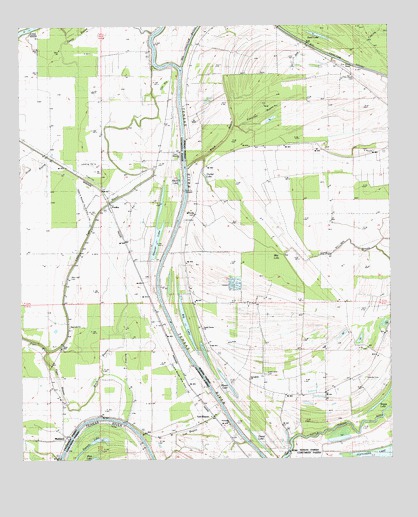
Foules, LA USGS Topographic Map
Click on map above to begin viewing in our Map Viewer.

This topographic map contains these locations and features:
Feature Name Type Latitude Longitude GNIS ID View Map
Alphenia ChurchChurchN31.8271°W91.5646°532144View Map
Alphenia LandingPopulated PlaceN31.8196°W91.5707°542923View Map
Anchor LandingPopulated PlaceN31.8499°W91.5698°542927View Map
Big Choctaw BayouStreamN31.8635°W91.5698°533061View Map
Big LakeLakeN31.7897°W91.5693°553649View Map
Black BayouGutN31.7827°W91.5923°533154View Map
Black BayouGutN31.8429°W91.5562°533155View Map
Black LakeLakeN31.8312°W91.5710°553689View Map
Blue LakeLakeN31.7557°W91.6010°553724View Map
Copeland LandingPopulated PlaceN31.8352°W91.5710°543104View Map
Crescent LandingPopulated PlaceN31.8599°W91.5698°543116View Map
Daniel LakeLakeN31.7542°W91.5442°554186View Map
Denmark LandingPopulated PlaceN31.8002°W91.5776°543140View Map
Devils BayouStreamN31.8732°W91.5798°534516View Map
Elder Shade CemeteryCemeteryN31.8599°W91.5121°534788View Map
Eltringham LandingPopulated PlaceN31.8079°W91.5762°543179View Map
FoulesPopulated PlaceN31.8224°W91.5951°543217View Map
French LakeLakeN31.7554°W91.6012°535103View Map
Frenches BayouGutN31.8518°W91.5382°535105View Map
Gin SloughGutN31.8560°W91.5771°554536View Map
GreenvillePopulated PlaceN31.7929°W91.5793°543258View Map
Greenville CemeteryCemeteryN31.8029°W91.5815°546017View Map
Hedgeland LandingPopulated PlaceN31.8699°W91.5810°543286View Map
Hoover LakeLakeN31.8165°W91.5784°554747View Map
Hunter LakeLakeN31.8319°W91.5624°554804View Map
Hunter LandingPopulated PlaceN31.7532°W91.5832°543321View Map
Kirks LandingPopulated PlaceN31.8646°W91.5737°543356View Map
Lee BayouGutN31.7588°W91.5693°536387View Map
Lee BayouPopulated PlaceN31.7632°W91.5604°543388View Map
Little Tiger BayouStreamN31.7818°W91.6160°536620View Map
Loam Land CemeteryCemeteryN31.7754°W91.5421°536644View Map
Loam Land SchoolSchoolN31.7724°W91.5479°536645View Map
Lower Tensas ChurchChurchN31.7882°W91.5632°556220View Map
MaitlandPopulated PlaceN31.7571°W91.6098°541625View Map
Maitland ChurchChurchN31.7557°W91.6107°536858View Map
Maitland LandingPopulated PlaceN31.7582°W91.6065°543436View Map
Martins LandingPopulated PlaceN31.8343°W91.5690°543449View Map
May LakeLakeN31.8482°W91.5246°555254View Map
Mayhew LandingPopulated PlaceN31.7610°W91.5896°543454View Map
Mile LakeLakeN31.8096°W91.5412°555315View Map
Mossy LakeLakeN31.7726°W91.5559°555381View Map
New Light CemeteryCemeteryN31.8029°W91.6084°537595View Map
New Light ChurchChurchN31.7885°W91.6090°537599View Map
New Zion CemeteryCemeteryN31.8382°W91.5709°537640View Map
New Zion ChurchChurchN31.8382°W91.5710°537649View Map
Oak Dale LandingPopulated PlaceN31.8288°W91.5682°543543View Map
OK LandingPopulated PlaceN31.7696°W91.5607°543542View Map
Olympic LandingPopulated PlaceN31.7579°W91.5507°543555View Map
Oneonta PlantationLocaleN31.8210°W91.5585°1631108View Map
Powells CemeteryCemeteryN31.7738°W91.5087°1629998View Map
Reed LakeLakeN31.8724°W91.5245°555788View Map
School House BayouGutN31.7563°W91.5598°539213View Map
Springfield ChurchChurchN31.7738°W91.5479°539603View Map
Sunnyside ChurchChurchN31.7599°W91.5551°539734View Map
Tensas Parish Fire District 1 Station 10BuildingN31.7693°W91.5225°2673023View Map
U and I LandingPopulated PlaceN31.7696°W91.5612°543743View Map
WildwoodPopulated PlaceN31.7860°W91.5765°556421View Map
Willow LakeSwampN31.8541°W91.5198°540464View Map
Young LandingPopulated PlaceN31.7691°W91.5593°543800View Map

Note: Coordinates in the location and feature list above are referenced to NAD83 datum.


Copyright (C) 2008-2025 Ryan Niemi / Sunset Dynamics ... All Rights Reserved