TopoQuest Logo
Do you find TopoQuest useful?
Help keep TopoQuest running and adding new maps/features by donating!
Bitcoin:  19c7KJd3qBynnjoSw5npx9KScwjBe4ifkT
Litecoin:  LXs6TkuXGGXo1vDsWCkWVdjQX94eUKd6ui
Home View Maps Find Maps Find Places Resources & Links


Sicily Island, Louisiana Topographic Map

USGS Map Title: Sicily Island, LA
USGS Map MRC: 31091G6
DRG (GeoTIFF) Download: o31091g6.tif


Neighboring USGS Topographic Map Quads:


  Extension, LA  
31091H7
 

  Wisner, LA  
31091H6
 

  Oakley, LA  
31091H5
 

  Harrisonburg, LA  
31091G7
 

  Sicily Island, LA  
31091G6
 

  Foules, LA  
31091G5
 

  Jonesville North, LA  
31091F7
 

  Dunbarton, LA  
31091F6
 

  Ferriday North, LA  
31091F5


Map MRC Location:

N32°
W92°
N32°
W91°
H8 H7 H6 H5 H4 H3 H2 H1
G8 G7 G6 G5 G4 G3 G2 G1
F8 F7 F6 F5 F4 F3 F2 F1
E8 E7 E6 E5 E4 E3 E2 E1
D8 D7 D6 D5 D4 D3 D2 D1
C8 C7 C6 C5 C4 C3 C2 C1
B8 B7 B6 B5 B4 B3 B2 B1
A8 A7 A6 A5 A4 A3 A2 A1
N31°
W92°
N31°
W91°

Sicily Island, LA USGS 1:24K Topographic Map Preview:
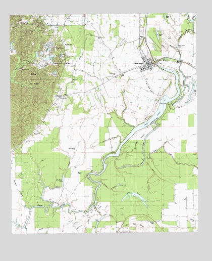
Sicily Island, LA USGS Topographic Map
Click on map above to begin viewing in our Map Viewer.

This topographic map contains these locations and features:
Feature Name Type Latitude Longitude GNIS ID View Map
Bayou FalconStreamN31.8446°W91.6498°532588View Map
Bayou Louis Oil FieldOilfieldN31.7591°W91.6965°541615View Map
Billys BayouGutN31.8335°W91.6340°533126View Map
Billys Bayou LakeLakeN31.8557°W91.6382°553666View Map
Black BayouStreamN31.7660°W91.7229°533160View Map
Black Bayou LakeLakeN31.7991°W91.7060°553674View Map
Brooks LakeLakeN31.8625°W91.6508°553781View Map
Buck LakeLakeN31.7847°W91.7028°553821View Map
Cash LakeLakeN31.7563°W91.6918°553915View Map
Catahoula Fire Protection District 6BuildingN31.8259°W91.7147°2673068View Map
Coon LakeLakeN31.8607°W91.6451°554077View Map
Duck CreekGutN31.8043°W91.6598°534633View Map
Duck Creek IslandIslandN31.7974°W91.6682°534635View Map
Ferry BayouGutN31.8210°W91.6396°534942View Map
Foules Church of GodChurchN31.7566°W91.6287°558353View Map
George LakeLakeN31.7774°W91.6785°554522View Map
Goose BayouGutN31.8035°W91.6843°535281View Map
Hawthorn BayouStreamN31.7641°W91.7376°535570View Map
Highland Park CemeteryCemeteryN31.8404°W91.6779°554710View Map
Hilde BayouStreamN31.7927°W91.6607°554708View Map
Hooter BayouGutN31.8257°W91.6751°535775View Map
Johnson BayouGutN31.7829°W91.6779°536077View Map
King BayouLakeN31.7697°W91.6626°536197View Map
LelandPopulated PlaceN31.8232°W91.7215°543394View Map
Leland Lookout TowerTowerN31.8702°W91.7407°546029View Map
Little Black LakeLakeN31.7808°W91.7154°536499View Map
Little Cash BayouStreamN31.7654°W91.6954°536507View Map
Lovelace LakeLakeN31.8121°W91.6591°555175View Map
Martin Junior High SchoolSchoolN31.8391°W91.6786°555841View Map
Mason CemeteryCemeteryN31.8282°W91.7162°541618View Map
New Hope ChurchChurchN31.8238°W91.7210°541617View Map
New Salem CemeteryCemeteryN31.8074°W91.7346°541616View Map
Norris CemeteryCemeteryN31.8557°W91.7137°541623View Map
Norris SpringsPopulated PlaceN31.8577°W91.7140°541624View Map
Old Pine Hill CemeteryCemeteryN31.8513°W91.7123°555658View Map
Old Salem CemeteryCemeteryN31.8477°W91.7146°541620View Map
Parish Governing Authority District 1CivilN31.7988°W91.6601°1929730View Map
Parish Governing Authority District 2CivilN31.7935°W91.7439°1929885View Map
Peck CemeteryCemeteryN31.8521°W91.7135°541622View Map
Peck Landing StripAirportN31.8332°W91.6571°546046View Map
Peniston CemeteryCemeteryN31.8513°W91.7135°541621View Map
Pentecostal ChurchChurchN31.8285°W91.7168°541619View Map
Pilgrim CemeteryCemeteryN31.8604°W91.6612°538137View Map
Pilgrim ChurchChurchN31.8610°W91.6601°538140View Map
Pine Hill Baptist ChurchChurchN31.8504°W91.7132°558286View Map
Pine Hill ChurchChurchN31.8460°W91.7129°556041View Map
Riffee LakeLakeN31.8346°W91.6301°555802View Map
Saint Paul Baptist ChurchChurchN31.8393°W91.6762°558312View Map
Sandy BayouGutN31.8649°W91.6318°539146View Map
Sheppards LakeLakeN31.8382°W91.6337°556019View Map
Short BayouStreamN31.7904°W91.6610°539351View Map
Sicily IslandPopulated PlaceN31.8466°W91.6562°556039View Map
Sicily Island CemeteryCemeteryN31.8463°W91.7118°556040View Map
Sicily Island Elementary SchoolSchoolN31.8435°W91.6561°546058View Map
Sicily Island High SchoolSchoolN31.8435°W91.6553°546059View Map
Sicily Island Oil and Gas FieldOilfieldN31.7682°W91.7182°556632View Map
Sicily Island Police StationBuildingN31.8462°W91.6595°2755238View Map
Sicily Island Post OfficePost OfficeN31.8472°W91.6590°1630431View Map
Sicily Island Volunteer Fire DepartmentBuildingN31.8462°W91.6595°2673075View Map
Tiger BayouStreamN31.7988°W91.6490°539921View Map
Village of Sicily IslandCivilN31.8494°W91.6598°2407545View Map
Ward OneCivilN31.8396°W91.6271°544972View Map
Ward TwoCivilN31.8382°W91.6960°544973View Map
Well LakeLakeN31.8299°W91.6289°556381View Map
Willow LakeLakeN31.7555°W91.6548°556436View Map

Note: Coordinates in the location and feature list above are referenced to NAD83 datum.


Copyright (C) 2008-2024 Ryan Niemi / Sunset Dynamics ... All Rights Reserved