TopoQuest Logo
Do you find TopoQuest useful?
Help keep TopoQuest running and adding new maps/features by donating!
Bitcoin:  19c7KJd3qBynnjoSw5npx9KScwjBe4ifkT
Litecoin:  LXs6TkuXGGXo1vDsWCkWVdjQX94eUKd6ui
Home View Maps Find Maps Find Places Resources & Links


Wisner, Louisiana Topographic Map

USGS Map Title: Wisner, LA
USGS Map MRC: 31091H6
DRG (GeoTIFF) Download: o31091h6.tif


Neighboring USGS Topographic Map Quads:


  Fort Necessity, LA  
32091A7
 

  Gilbert, LA  
32091A6
 

  Como, LA  
32091A5
 

  Extension, LA  
31091H7
 

  Wisner, LA  
31091H6
 

  Oakley, LA  
31091H5
 

  Harrisonburg, LA  
31091G7
 

  Sicily Island, LA  
31091G6
 

  Foules, LA  
31091G5


Map MRC Location:

N32°
W92°
N32°
W91°
H8 H7 H6 H5 H4 H3 H2 H1
G8 G7 G6 G5 G4 G3 G2 G1
F8 F7 F6 F5 F4 F3 F2 F1
E8 E7 E6 E5 E4 E3 E2 E1
D8 D7 D6 D5 D4 D3 D2 D1
C8 C7 C6 C5 C4 C3 C2 C1
B8 B7 B6 B5 B4 B3 B2 B1
A8 A7 A6 A5 A4 A3 A2 A1
N31°
W92°
N31°
W91°

Wisner, LA USGS 1:24K Topographic Map Preview:
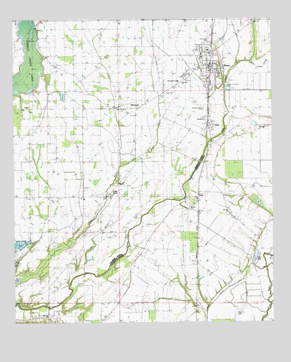
Wisner, LA USGS Topographic Map
Click on map above to begin viewing in our Map Viewer.

This topographic map contains these locations and features:
Feature Name Type Latitude Longitude GNIS ID View Map
Assembly of God Church (historical)ChurchN31.9999°W91.6718°541628View Map
Black BayouStreamN31.9393°W91.6993°533162View Map
Boggy BayouGutN31.9027°W91.6285°533289View Map
Central CemeteryCemeteryN31.9627°W91.6993°533854View Map
Central ChurchChurchN31.9627°W91.6993°533856View Map
Ditto LakeLakeN31.9020°W91.6339°554244View Map
ElamPopulated PlaceN31.9549°W91.6568°543168View Map
Green LakeLakeN31.8768°W91.6435°554615View Map
Holly GrovePopulated PlaceN31.9279°W91.7035°558784View Map
Hope Estate CemeteryCemeteryN31.9924°W91.6548°541627View Map
Hope Well ChurchChurchN31.8777°W91.7343°556631View Map
Hope Will CemeteryCemeteryN31.8771°W91.7343°546023View Map
Humble CemeteryCemeteryN31.9127°W91.7140°535856View Map
Loften BayouStreamN31.8952°W91.7171°536656View Map
MetropolisPopulated PlaceN31.9635°W91.6912°543466View Map
Mount Olive ChurchChurchN31.9221°W91.6657°537360View Map
Natchez Fort (historical)LocaleN31.8977°W91.6410°551563View Map
New Alpha and Omega ChurchChurchN31.9740°W91.6698°541630View Map
New Light ChurchChurchN31.9732°W91.6726°537600View Map
New Zion CemeteryCemeteryN31.9193°W91.6471°537641View Map
New Zion ChurchChurchN31.9207°W91.6471°537650View Map
Norris Hill ChurchChurchN31.9557°W91.6290°537708View Map
North Sicily Island Gas FieldOilfieldN31.8754°W91.6946°546041View Map
Parish Governing Authority District 7CivilN31.9769°W91.6871°1930187View Map
PeckPopulated PlaceN31.9252°W91.6612°543570View Map
Saint Paul Church Number 2ChurchN31.9963°W91.6398°539030View Map
Saint Peter's ChurchChurchN31.9082°W91.7437°539052View Map
Sims LakeLakeN31.9963°W91.7410°556052View Map
Smith BayouGutN31.8849°W91.6276°539426View Map
Town of WisnerCivilN31.9804°W91.6551°2406907View Map
Turkey Creek LakeReservoirN31.9745°W91.7469°541682View Map
Ward OneCivilN31.9585°W91.6893°545026View Map
Willis LakeLakeN31.9765°W91.7440°556429View Map
WisnerPopulated PlaceN31.9810°W91.6557°543792View Map
Wisner Elementary School (historical)SchoolN31.9856°W91.6601°544109View Map
Wisner High School (historical)SchoolN31.9842°W91.6582°544110View Map
Wisner Oil FieldOilfieldN31.9627°W91.7435°541631View Map
Wisner Police DepartmentBuildingN31.9807°W91.6552°2755354View Map
Wisner Post OfficePost OfficeN31.9806°W91.6563°2759267View Map
Wisner Volunteer Fire DepartmentBuildingN31.9810°W91.6568°2673109View Map
Yarbrough Brothers AirstripAirportN31.9621°W91.6582°544112View Map

Note: Coordinates in the location and feature list above are referenced to NAD83 datum.


Copyright (C) 2008-2025 Ryan Niemi / Sunset Dynamics ... All Rights Reserved