TopoQuest Logo
Do you find TopoQuest useful?
Help keep TopoQuest running and adding new maps/features by donating!
Bitcoin:  19c7KJd3qBynnjoSw5npx9KScwjBe4ifkT
Litecoin:  LXs6TkuXGGXo1vDsWCkWVdjQX94eUKd6ui
Home View Maps Find Maps Find Places Resources & Links


Zama, Mississippi Topographic Map

USGS Map Title: Zama, MS
USGS Map MRC: 32089H4
DRG (GeoTIFF) Download: o32089h4.tif


Neighboring USGS Topographic Map Quads:


  Kosciusko, MS  
33089A5
 

  Ethel South, MS  
33089A4
 

  Ethel SE, MS  
33089A3
 

  Singleton, MS  
32089H5
 

  Zama, MS  
32089H4
 

  Four Corners, MS  
32089H3
 

  Conway, MS  
32089G5
 

  Renfroe, MS  
32089G4
 

  Edinburg, MS  
32089G3


Map MRC Location:

N33°
W90°
N33°
W89°
H8 H7 H6 H5 H4 H3 H2 H1
G8 G7 G6 G5 G4 G3 G2 G1
F8 F7 F6 F5 F4 F3 F2 F1
E8 E7 E6 E5 E4 E3 E2 E1
D8 D7 D6 D5 D4 D3 D2 D1
C8 C7 C6 C5 C4 C3 C2 C1
B8 B7 B6 B5 B4 B3 B2 B1
A8 A7 A6 A5 A4 A3 A2 A1
N32°
W90°
N32°
W89°

Zama, MS USGS 1:24K Topographic Map Preview:
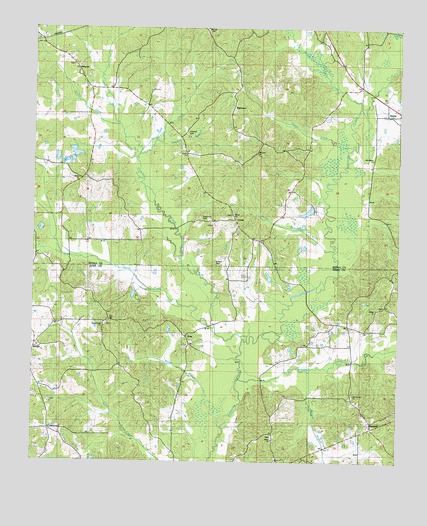
Zama, MS USGS Topographic Map
Click on map above to begin viewing in our Map Viewer.

This topographic map contains these locations and features:
Feature Name Type Latitude Longitude GNIS ID View Map
Antioch CemeteryCemeteryN32.9696°W89.4473°666289View Map
Archie CreekStreamN32.9774°W89.3887°666349View Map
Bethel CemeteryCemeteryN32.9196°W89.3823°707064View Map
Bethel ChurchChurchN32.9199°W89.3828°666924View Map
Bethel School (historical)SchoolN32.9193°W89.3834°707065View Map
Beulah (historical)Populated PlaceN32.9557°W89.4848°710835View Map
Beulah Baptist ChurchChurchN32.9568°W89.4842°691130View Map
Beulah School (historical)SchoolN32.9571°W89.4856°710836View Map
Bibalucta CreekStreamN32.8979°W89.4301°667066View Map
Canna CreekStreamN32.9662°W89.3901°668048View Map
CenterPopulated PlaceN32.9454°W89.4309°690910View Map
Center Baptist ChurchChurchN32.9457°W89.4309°710856View Map
Center CemeteryCemeteryN32.9462°W89.4315°710857View Map
Center ChurchChurchN32.9640°W89.4476°691136View Map
Center School (historical)SchoolN32.9454°W89.4306°710860View Map
Chestnut CreekStreamN32.9629°W89.4642°668375View Map
CrossroadPopulated PlaceN32.8840°W89.4945°691791View Map
Fuller CreekStreamN32.9724°W89.4709°670266View Map
GrayPopulated PlaceN32.9112°W89.4470°691903View Map
Gregory Lake DamDamN32.9451°W89.4017°681753View Map
Harper BranchStreamN32.9021°W89.4062°670950View Map
Jamison BranchStreamN32.9674°W89.4565°671811View Map
Jim Hudgins Pond DamDamN32.9151°W89.4117°681737View Map
Kenty CreekStreamN32.9101°W89.4262°672110View Map
MarydellPopulated PlaceN32.8854°W89.3837°673217View Map
Marydell Volunteer Fire DepartmentBuildingN32.8752°W89.4174°2665791View Map
Mount Cana ChurchChurchN32.9643°W89.4234°691153View Map
Mount Harmon ChurchChurchN32.8946°W89.3906°691154View Map
New Salem ChurchChurchN32.9626°W89.3840°691104View Map
Pailey CreekStreamN32.9140°W89.4378°675384View Map
Parker BranchStreamN32.8851°W89.4348°675454View Map
PattersonPopulated PlaceN32.9776°W89.4320°692132View Map
Patterson CemeteryCemeteryN32.9457°W89.4426°675496View Map
Patterson ChurchChurchN32.9774°W89.4312°710967View Map
Patterson School (historical)SchoolN32.9771°W89.4312°710968View Map
Peeler BranchStreamN32.9371°W89.3965°675572View Map
Peeler ChurchChurchN32.9460°W89.4312°691103View Map
Pilgrims Rest School (historical)SchoolN32.9990°W89.3773°710976View Map
Rocky Point CemeteryCemeteryN32.9143°W89.4762°707150View Map
Rocky Point ChurchChurchN32.9143°W89.4765°676802View Map
Rocky Point School (historical)SchoolN32.9143°W89.4765°707151View Map
Salem CemeteryCemeteryN32.8818°W89.4176°707155View Map
Salem ChurchChurchN32.8812°W89.4176°677280View Map
Sandridge Lake DamDamN32.9635°W89.4867°681762View Map
Shield CemeteryCemeteryN32.9326°W89.4378°677661View Map
SmyrnaPopulated PlaceN32.9887°W89.4854°692238View Map
Smyrna CemeteryCemeteryN32.9893°W89.4870°691056View Map
Smyrna High School (historical)SchoolN32.9885°W89.4865°711008View Map
Smyrna Presbyterian ChurchChurchN32.9890°W89.4865°711010View Map
ZamaPopulated PlaceN32.9751°W89.3801°691172View Map

Note: Coordinates in the location and feature list above are referenced to NAD83 datum.


Copyright (C) 2008-2025 Ryan Niemi / Sunset Dynamics ... All Rights Reserved