TopoQuest Logo
Do you find TopoQuest useful?
Help keep TopoQuest running and adding new maps/features by donating!
Bitcoin:  19c7KJd3qBynnjoSw5npx9KScwjBe4ifkT
Litecoin:  LXs6TkuXGGXo1vDsWCkWVdjQX94eUKd6ui
Home View Maps Find Maps Find Places Resources & Links


Four Points, Georgia Topographic Map

USGS Map Title: Four Points, GA
USGS Map MRC: 32081F8
DRG (GeoTIFF) Download: o32081f8.tif


Neighboring USGS Topographic Map Quads:


  Birdsville, GA  
32082G1
 

  Millen, GA  
32081G8
 

  Bay Branch, GA  
32081G7
 

  Garfield, GA  
32082F1
 

  Four Points, GA  
32081F8
 

  Rocky Ford, GA  
32081F7
 

  Twin City SE, GA  
32082E1
 

  Portal, GA  
32081E8
 

  Hopeulikit, GA  
32081E7


Map MRC Location:

N33°
W82°
N33°
W81°
H8 H7 H6 H5 H4 H3 H2 H1
G8 G7 G6 G5 G4 G3 G2 G1
F8 F7 F6 F5 F4 F3 F2 F1
E8 E7 E6 E5 E4 E3 E2 E1
D8 D7 D6 D5 D4 D3 D2 D1
C8 C7 C6 C5 C4 C3 C2 C1
B8 B7 B6 B5 B4 B3 B2 B1
A8 A7 A6 A5 A4 A3 A2 A1
N32°
W82°
N32°
W81°

Four Points, GA USGS 1:24K Topographic Map Preview:
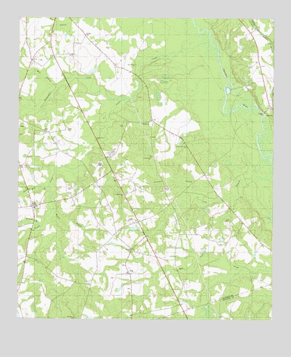
Four Points, GA USGS Topographic Map
Click on map above to begin viewing in our Map Viewer.

This topographic map contains these locations and features:
Feature Name Type Latitude Longitude GNIS ID View Map
Aycock CemeteryCemeteryN32.6802°W81.9271°310689View Map
Bethlehem ChurchChurchN32.6257°W81.9709°311235View Map
Clifton CemeteryCemeteryN32.7035°W81.9757°312749View Map
Elam ChurchChurchN32.6713°W81.9921°313884View Map
Four PointsPopulated PlaceN32.6718°W81.9932°326293View Map
Gays Hill ChurchChurchN32.6541°W81.9440°314548View Map
Gordon Grove ChurchChurchN32.6966°W81.9173°314715View Map
Gordons School (historical)SchoolN32.7279°W81.9884°342981View Map
Hooker BranchStreamN32.6707°W81.9826°315625View Map
Lane CemeteryCemeteryN32.7032°W81.9871°316616View Map
Lanier CemeteryCemeteryN32.6660°W81.8979°316639View Map
Long Branch ChurchChurchN32.6768°W81.9479°317340View Map
Long Branch School (historical)SchoolN32.6743°W81.9251°342995View Map
Milburne LakeReservoirN32.6628°W81.9427°341655View Map
Milburne Lake DamDamN32.6618°W81.9415°341654View Map
Mill BranchStreamN32.7207°W81.9804°318183View Map
Mount Carmel Church (historical)ChurchN32.6635°W81.8871°343000View Map
Newton LakeReservoirN32.7280°W81.9638°340299View Map
Newton Lake DamDamN32.7285°W81.9648°340298View Map
Paynes ChapelChurchN32.6660°W81.9454°320300View Map
Paynes Chapel CemeteryCemeteryN32.6660°W81.9459°343003View Map
Richardson CreekStreamN32.7168°W81.9468°321570View Map
Rooty Branch School (historical)SchoolN32.6346°W81.9796°343005View Map
Saint Matthews ChurchChurchN32.6921°W81.9351°322223View Map
Sand Hill BranchStreamN32.6816°W81.9843°322416View Map
ScarboroPopulated PlaceN32.7132°W81.8754°356522View Map
Scarboro BranchStreamN32.7046°W81.8790°322618View Map
Sculls CreekStreamN32.7402°W81.9062°356527View Map
Sculls Creek ChurchChurchN32.7307°W81.9432°322672View Map
Southwell BranchStreamN32.6743°W81.9118°323311View Map
Wildcat BranchStreamN32.6641°W81.9896°325269View Map
Williams CemeteryCemeteryN32.6790°W81.9754°325332View Map
Williams Grove ChurchChurchN32.7002°W81.9612°325357View Map

Note: Coordinates in the location and feature list above are referenced to NAD83 datum.


Copyright (C) 2008-2025 Ryan Niemi / Sunset Dynamics ... All Rights Reserved